
This Circular stipulates technical regulations for establishing national topographic maps at scales of 1:10,000 and 1:25,000, including mathematical basis, map accuracy, map content, and map symbols. The Circular takes effect from November 30, 2020, and replaces certain previous decisions in the same field.
Đối tượng áp dụng
Ministries, ministerial-level agencies, government agencies, provincial people's committees under the central government, and organizations and individuals related to the establishment of national topographic maps at scales of 1:10,000 and 1:25,000.
Các điểm cốt lõi
- Regulations on mathematical basis and map accuracy for national topographic maps.
- Detailed content of data groups on the map such as geography, hydrology, vegetation, irrigation...
- Map symbols are specified in Appendix 2.
- This Circular takes effect from November 30, 2020, and replaces certain previous decisions in the same field.
- Require relevant agencies, organizations, and individuals to implement this Circular.
🌐 Tác động xã hội từ văn bản này
- Ensure the quality and accuracy of national topographic maps.
- Support land management, socio-economic development planning.
- Provide basic information for scientific research, education, tourism...
❓ Câu hỏi thường gặp
Which decision does this Circular replace?
This Circular replaces Decision No. 1126/ĐĐBĐ dated November 19, 1994, issued by the Director General of the Land Administration General Department regarding the symbols of national topographic maps at scales of 1:10,000 and 1:25,000.
When does this Circular take effect?
This Circular takes effect from November 30, 2020.
What are the main contents of this Circular?
Main contents include regulations on the mathematical basis and map accuracy for national topographic maps, detailed content of data groups on the map such as geography, hydrology, vegetation, irrigation...
Who does this Circular apply to?
This Circular applies to ministries, ministerial-level agencies, government agencies, provincial people's committees under the central government, and organizations and individuals related to the establishment of national topographic maps at scales of 1:10,000 and 1:25,000.
Toàn văn
|
MINISTRY OF NATURAL RESOURCES AND ENVIRONMENT SOURCE AND ENVIRONMENT Number: 12/2020/TT-MT |
SOCIALIST REPUBLIC OF VIET NAM Independence - Freedom - Happiness Hanoi, September 30, 2020 |
CIRCULAR
Technical regulations on the content and symbols of national topographic maps at scales of 1:10,000 and 1:25,000
national topographic map at scales of 1:10,000 and 1:25,000
Pursuant to the Law on Surveying and Mapping dated June 14, 2018;
Pursuant to Decree No. 27/2019/ND-CP dated March 13, 2019 of the Government detailing some articles of the Law on Surveying and Mapping;
Pursuant to Decree No. 36/2017/ND-CP dated April 4, 2017 of the Government stipulating the functions, tasks, powers, and organizational structure of the Ministry of Natural Resources and Environment;
The Minister of Natural Resources and Environment promulgates this Circular on technical regulations on the structure model and content of the national geographic base database at scales of 1:10,000 and 1:25,000.
The Minister of Natural Resources and Environment promulgates this Circular on technical regulations regarding the content and symbols of national topographic maps at scales of 1:10,000 and 1:25,000.
PART I
GENERAL PROVISIONS
Article 1. Scope of Regulation
This Circular stipulates technical regulations on the content and symbols of national topographic maps at scales of 1:10,000 and 1:25,000.
Article 2. Applicability
This Circular applies to agencies, organizations, and individuals related to the establishment, storage, management, and provision of national topographic maps at scales of 1:10,000 and 1:25,000.
Article 3. Explanation of Terms
In this Circular, the following terms shall be understood as follows:
1. National topographic maps at scales of 1:10,000 and 1:25,000 are maps representing the characteristics of terrain, geographic features, borders, administrative boundaries, and place names on land, islands, and archipelagos constructed according to national technical standards and norms at scales of 1:10,000 and 1:25,000 within the national coordinate system and national height system for uniform use throughout the country.
2. Proportional symbols are symbols whose size is proportional to the actual size of the geographic object.
3. Semi-proportional symbols are symbols whose one-dimensional size is proportional to the actual size of the geographic object, while the other dimension represents a convention.
4. Non-proportional symbols are geometric shapes representing the geographic object with a conventional size that does not follow the actual size of the geographic object.
5. National coordinate points are national survey points with spatial coordinates established according to national technical standards and norms, and technical regulations.
6. National height points are national survey points with elevation values established according to national technical standards and norms, and technical regulations.
7. National coordinate and height points are national survey points with spatial coordinates and elevation values established according to national technical standards and norms, and technical regulations.
8. National gravity points are national survey points with values of gravitational acceleration established according to national technical standards and norms, and technical regulations.
9. GeoTIFF is a georeferenced image format.
Article 4. Mathematical Basis
1. National topographic maps at scales of 1:10,000 and 1:25,000 are established in the national reference system and coordinate system VN-2000, and the national height system.
2. National topographic maps at a scale of 1:10,000 are established in the transverse cylindrical equal-area projection with a central meridian of 3° and a scale factor of 0.9999. National topographic maps at a scale of 1:25,000 are established in the transverse cylindrical equal-area projection with a central meridian of 6° and a scale factor of 0.9996.
3. The zone number and the axis meridian of each zone are as follows in Table 1 below:
Table 1
| Zone 60 | Zone 30 | ||
|
Zone Number |
Axis Meridian | Zone Number | Axis Meridian |
| 48 |
1050 | 481 | 1020 |
| 482 | 1050 | ||
| 49 | 1110 | 491 | 1080 |
| 492 | 1110 | ||
| 50 | 1170 | 501 | 1140 |
| 502 | 1170 | ||
4. Division into sections and designation of section identifiers for national topographic maps at scales of 1:10,000 and 1:25,000 shall be carried out in accordance with Circular No. 973/2001/TT-TCDT dated June 20, 2001 of the General Department of Land Administration (now the Ministry of Natural Resources and Environment) "Guidelines for Applying the National Reference System and Coordinate System VN-2000" as follows:
a) Division into sections and designation of section identifiers for national topographic maps at a scale of 1:25,000
Each national topographic map at a scale of 1:50,000 is divided into four national topographic maps at a scale of 1:25,000, each having a size of 7'30"x7'30", identified by four Latin letters a, b, c, d in order from left to right and from top to bottom.
The identifier of a section of a national topographic map at a scale of 1:25,000 consists of the identifier of the section of the national topographic map at a scale of 1:50,000 containing that section, a hyphen, and then the identifier of the section of the national topographic map at a scale of 1:25,000 within the section of the national topographic map at a scale of 1:50,000.
For example, a section of a national topographic map at a scale of 1:25,000 has the identifier F-48-68-D-.
b) Division into sections and designation of section identifiers for national topographic maps at a scale of 1:10,000
Each section of a national topographic map at a scale of 1:25,000 is divided into four sections of national topographic maps at a scale of 1:10,000, each having a size of 3'45"x3'45", identified by numbers 1, 2, 3, 4 in order from left to right and from top to bottom.
The identifier of a section of a national topographic map at a scale of 1:10,000 consists of the identifier of the section of the national topographic map at a scale of 1:25,000 containing that section, a hyphen, and then the identifier of the section of the national topographic map at a scale of 1:10,000 within the section of the national topographic map at a scale of 1:25,000.
For example, a section of a national topographic map at a scale of 1:10,000 has the identifier F-48-68-D-d-4.
Article 5. Accuracy of Maps
1. The mean error regarding the plane of geographic objects represented on national topographic maps at the scale of establishment shall not exceed the following values:
a) 0.5 mm on the map for plain areas, hills, and low mountains;
b) 0.7 mm on the map for high mountains and hidden areas.
2. The mean error regarding the height of geographic objects represented on national topographic maps shall not exceed the values specified in Table 2 below:
Table 2
|
Basic contour interval (m) |
Permitted mean error for height (m) | |
| 1:10.000 | 1:25.000 | |
|
1 |
0.25 | |
| 2.5 | 0,8 | 0,8 |
| 5 | 1,7 | 1,7 |
| 10 | 5 | 5 |
| 20 | 10 | |
For hidden areas and those with particularly difficult terrain, the above errors may be increased by 1.5 times.
3. The limit error regarding the plane and height of geographic objects shall not exceed 2.5 times the mean error, and the number of cases with errors greater than 2.0 times the mean error shall not exceed 5% of the total number of cases checked. In all cases, the errors must not be systematic.
Article 6. Product Format
National topographic maps at scales of 1:10,000 and 1:25,000 include digital national topographic maps and printed national topographic maps on paper. Digital national topographic maps are in GeoTIFF and GeoPDF formats accompanied by metadata files.
Chapter II
CONTENT AND SYMBOLS
Article 7. Content of National Topographic Maps at Scales of 1:10,000 and 1:25,000
1. National topographic maps at scales of 1:10,000 and 1:25,000 are established from the national geographic database, including the following data layers:
a) Mathematical base layer group;
b) Border and administrative boundary data layer;
c) Population data layer;
d) Terrain data layer;
đ) Transportation data layer;
e) Vegetation cover data layer;
g) Hydrographic data layer.
2. The content of national topographic maps at scales of 1:10,000 and 1:25,000 is expressed through corresponding symbols according to the National Topographic Map Symbols at Scales of 1:10,000 and 1:25,000 stipulated in Article 16 of this Circular.
3. The accuracy of representing the elements of the map's content must comply with the provisions of Article 5 of this Circular.
Article 8. General Provisions on Expressing Map Content
1. The content of national topographic maps at scales of 1:10,000 and 1:25,000 is expressed as follows:
a) By proportional symbols when geographic objects in linear form have widths of 5.0 m or more at a scale of 1:10,000 and 12.5 m or more at a scale of 1:25,000; for geographic objects in area form, they are generally expressed by proportional symbols detailed according to each group of map data;
b) By half-proportional symbols when geographic objects in linear form have widths less than 5.0 m at a scale of 1:10,000 and less than 12.5 m at a scale of 1:25,000;
c) By non-proportional symbols for geographic objects that cannot be drawn proportionally or when additional symbolic representations need to be placed between proportional symbols to enhance the clarity of the map;
d) By explanatory notes when geographic objects do not have common symbols or to explain the characteristics of geographic objects. Geographic objects without representative symbols must be annotated according to the provisions of Appendix 3 issued together with this Circular.
2. Elements of content must be presented parallel to the southern frame of the map:
a) Non-proportional symbols except for non-proportional house symbols and symbols representing related geographic objects;
b) Names of populated places, administrative units;
c) Annotations of point heights, object heights, and characteristic explanations;
d) Names of objects and explanatory annotations;
đ) Representative symbols for vegetation distribution and soil types.
3. Other symbols and annotations are arranged according to the direction of the object, with the top of letters and numbers facing upwards. Height annotations, contour lines, and leading digits must face the higher elevation and upward. Annotations not arranged according to the direction of the object can be arranged parallel to the southern frame of the map.
4. The position of symbol centers is defined as follows:
a) Symbols with basic geometric shapes: the center of the symbol is the center of these basic shapes;
b) Symbolic representations with a base line: the center of the symbol is the midpoint of the base line;
c) Symbols with perpendicular feet or round dots, circles at the foot: the center of the symbol is the vertex of the right angle at the foot or the center of the round dot at the foot;
d) Hollow-footed symbols: the center of the symbol is midway between the two feet;
đ) Linear symbols: the center of the symbol is the middle axis of the symbol.
5. When using symbols to accurately represent the location of geographic objects, the center of the symbol must coincide with the center of the object.
6. When multiple geographic objects are close to each other, it is required to accurately express the geographic objects with higher priority and those with higher positional significance first. Geographic objects with lower priority are expressed intermittently or yield to others. The priority levels of geographic objects when expressed on national topographic maps at scales of 1:10,000 and 1:25,000 are specifically as follows:
a) For independent geographic objects, the priority order of expression is as follows: national survey points; geographic objects with higher positional significance and more durable materials;
b) For linear geographic objects, the priority order is as follows: railways, roads (from expressways, national highways to provincial roads, district roads, other traffic roads), water boundaries, land use boundaries, vegetation boundaries;
c) In special cases, symbols may be shifted by up to 0.2 mm on the map but must ensure compliance with the priority levels of geographic objects.
7. When symbols intersect, the symbol with higher spatial position or priority level is fully expressed, while the symbol below is broken to avoid crossing the symbol above.
8. For non-proportional symbols with their centers within the map fragment, parts extending beyond the inner frame should not exceed 1/4 of the symbol and should be drawn outside the frame to complete the representation. If the center is on the inner frame line, it must be shown on both adjacent map fragments, with the frame line stopping 0.2 mm away from the symbol.
9. Principles for expressing the names of geographic objects on maps
a) Express names according to existing place names in the geographic database;
b) When the name has not been established or has changed compared to the geographical name database, it must be investigated and collected according to legal documents of competent authorities and verified on-site. In the metadata file, these geographical names are recorded as unstandardized geographical names.
c) For densely populated areas, the font size may be reduced to two-thirds of the specified size in the symbol.
d) When displaying the names of geographical objects, priority should be given to larger, significant, famous, or directional objects. If the map's tolerance does not allow for the full display of the names of geographical objects as stipulated in Articles 10, 11, 12, 13, 14, and 15 of this Circular, or if fully displaying them would affect other map contents and readability, abbreviated common nouns may be used. Abbreviations of common nouns are only used for geographical objects without common symbols. These abbreviations follow the provisions set out in Appendix 3 issued with this Circular.
đ) Geographical objects with wide distribution should display their names within the distribution range of the object and can be repeated at appropriate intervals and aesthetically pleasing distances.
e) For linear geographical objects, names should be repeated at intervals from 10.0 to 15.0 cm.
g) For geographical objects spanning multiple map sheets, their names should be displayed on all sheets when the map's content tolerance allows.
Article 9. Provisions on the Content of Mathematical Base Classes
1. The mathematical base classes on the map include contents related to the map projection grid, sheet designation, scale, coordinate points, and elevation points within the sheet, and contents presented outside the sheet frame, specifically as follows:
a) The map projection grid is shown on the map using a rectangular coordinate grid and geographic coordinates. A rectangular coordinate grid with a density of 1.0 km x 1.0 km and the adjacent zone's rectangular coordinate grid if the map sheet is at the edge of the projection zone; Geographic coordinate grid is shown with a density of 1' x 1' at the midpoint between inner and outer frames according to the model in Appendices 4 and 5 issued with this Circular. The length of odd minutes is blackened, even minutes are not.
b) Each national topographic map sheet at scales of 1:10,000 and 1:25,000 must have the sheet name and sheet designation fully. Sheet designations comply with the provisions of Clause 4, Article 4 of this Circular. The name of the sheet is taken from the largest populated area within the sheet. If there is no populated area, the name of the largest or highest land feature within the sheet is chosen.
c) The map scale is shown below the southern frame according to the specified font size, accompanied by the corresponding scale bar.
d) The inner frame of the map sheet limits the standard size of the sheet as provided for in Clause 4, Article 4 of this Circular. When creating the map, if the mainland (or Vietnamese territory) occupies less than one-quarter of the sheet area, it is allowed to join the sheet to the adjacent sheet if that part is contiguous with it. The adjacent sheet is permitted to expand its frame (called breaking the frame). The expanded frame boundary must take the nearest even meridian or parallel up to 05 as the limit for the sheet.
đ) Inner frame annotations include administrative unit names next to the frame, adjacent sheet designations, and geographic coordinates at the four corners of the frame, expressed to the second. Additionally, the distance in kilometers from the discontinuous railway or road at the map frame to the nearest station or center of the nearest populated point or prominent landmark must be annotated.
e) Contents presented outside the frame include: sheet name, sheet designation, country name at the corner of the frame, province name at the corner of the frame, district name at the corner of the frame, splice table, symbol explanation, map scale, mean sea level height difference, scale bar, slope scale, southern frame annotation; for national topographic maps at a scale of 1:25,000, there is also a magnetic declination diagram. The content of the southern frame annotation in the Southeast corner outside the frame includes: project sponsor, establishment method, year of establishment, establishment unit, coordinate reference system information, height system, central meridian; for printed maps, additional information about the printing organization and the year of map printing is included.
2. Symbols and detailed technical requirements for the content of the mathematical base classes of the National Topographic Map at a scale of 1:10,000 and the National Topographic Map at a scale of 1:25,000 are stipulated respectively in Section II of Appendices 2, 4, and 5 issued with this Circular.
Article 10. Provisions on the content of the group layer data of national borders and administrative boundaries
1. The group layer data of national borders and administrative boundaries shall reflect the national border lines, the system of national boundary markers; distinctive features of the national border; and the administrative boundary lines at various levels and administrative boundary markers.
2. National border lines and national boundary markers must be fully, accurately, and consistently reflected according to the standard national border map. In cases where there is no standard national border map, the national border lines and national boundary markers shall be transferred and drawn according to the provisions set forth in Article 12 of Circular No. 17/2018/TT-BTNMT dated October 31, 2018, issued by the Minister of Natural Resources and Environment, concerning technical regulations for establishing and updating the standard national border map and reflecting the national border lines and national sovereignty on surveying products and maps, and map publications. The national border line must be continuously reflected without interruption.
3. Administrative boundary lines at various levels must be fully reflected according to the administrative boundary map at the same scale or the closest scale to the map. Administrative boundary lines must be continuously reflected without interruption until they intersect with the administrative boundary lines of the same level.
4. Selection of representation of administrative boundary markers at various levels: Priority should be given to the representation of provincial-level and district-level markers; only select the representation of commune-level markers that have three sides and special significance. Do not annotate the marker numbers of administrative boundary markers.
5. The representation of national border lines and administrative boundary lines at various levels shall follow the following principles:
a) In cases where administrative boundary lines at various levels coincide with the object lines represented at half scale, or according to scale but the width of the object lines on the map is less than 1 mm, they may be shifted and represented offset on both sides of the object lines, each segment being from 3 to 4 tick marks. The distance from the administrative boundary lines at various levels to the object lines on the map is 0.2 mm. Apply this similarly in cases where national border lines coincide with the object lines represented at half scale or according to scale when the width of the object lines on the map is less than 2.0 mm;
b) In cases where national border lines coincide with the object lines represented according to scale on the map with a width of 2.0 mm or more, and administrative boundary lines at various levels coincide with the object lines represented according to scale on the map with a width of 1.0 mm or more, national border lines on land and administrative boundary lines at various levels shall be represented inside the object lines;
c) At the end or beginning of a segment of the national border line or administrative boundary lines at various levels, the symbols must be fully represented without excess or missing strokes. Three-way and four-way intersections of national border lines and administrative boundary lines at various levels must clearly show the intersection of the symbols.
6. Representation of the names of administrative units shall follow the following principles:
a) Within the scope of the map sheet: The name of the commune-level administrative unit shall be arranged in the central area of the commune's administrative scope. In cases where the commune's scope is divided across multiple map sheets, the name shall be shown on the sheet with the widest scope or the highest population concentration. The name shall include all common nouns and specific nouns, without abbreviations.
The name of the district-level administrative unit shall be shown below the name of the district capital. If the name of the residential area coincides with the name of the district, then the name of the district shall not be shown.
The name of the provincial-level administrative unit shall be shown below the name of the provincial capital. If the name of the residential area coincides with the name of the province, then the name of the province shall not be shown.
b) Outside the frame of the map sheet: The names of administrative units at various levels shall be shown outside the map frame, on both ends of the corresponding administrative boundary. The name shall include all common nouns and specific nouns, without abbreviations.
7. The objects of the content of the group layer data of national borders and administrative boundaries shall be represented by corresponding symbols as specified in Section I of Appendix 2 attached to this Circular.
Article 11. Provisions on the content of the population data layer group
1. The population data layer group reflects residential areas and related facilities, including urban residential areas, rural residential areas, industrial zones, special-purpose functional zones, public works, economic bases, cultural and social facilities.
2. Houses are represented on maps using corresponding symbols for three types of building blocks: buildings, and simple houses. Distinguish between houses and building blocks according to the number of floors and groups of floors with seven floors or less and eight floors or more using corresponding symbols.
3. Principles for representing houses and building blocks.
a) For a scale of 1:10,000, houses with an area smaller than 70.0 square meters and houses with a width smaller than 7 meters shall be indicated by non-proportional house symbols. For a scale of 1:25,000, houses with an area smaller than 500.0 square meters and houses with a width smaller than 20 meters shall be indicated by non-proportional house symbols.
b) Prioritize the representation of road edge symbols, symbols indicating the boundaries of construction projects, and special-purpose functional zones when these objects coincide with house outline symbols.
4. People's Committees at all levels are represented by symbols placed at the location of their office buildings.
5. Represent water towers, reservoirs with directional characteristics, national meteorological and hydrological stations, environmental monitoring stations, water resource monitoring stations, transmission or antenna towers on the ground with a height of 30.0 meters or more, and all radio and television broadcasting antennas belonging to radio and television stations.
6. The power transmission system includes high and medium voltage transmission lines with voltages of 22 KV or higher and substations. Power transmission lines must indicate voltage ratings, start and end at poles or substations, and be represented as a system.
7. For geographic objects represented on maps at scales without specific prescribed symbols, explanatory notes must be used to represent them according to the priority order principle. Boundaries of construction projects and special-purpose functional zones are represented on maps using fence, wall, land use boundary, and restricted area boundary symbols with lengths of 10.0 millimeters or more on the map.
8. Land use boundaries and restricted area boundaries are represented based on materials from competent authorities.
9. Representation of names of population objects.
Depending on the economic and cultural development status of each area where the map is created and the capacity of the map to accommodate content objects at different scales, choose to represent the names of the following population objects appropriately, reflecting the characteristics of the area. Fully represent the names of population objects when the map's capacity allows.
a) Residential areas;
b) Special-purpose functional zones including: industrial zones, export processing zones, economic zones, high-tech zones, tourist zones, research and training zones, sports and recreation zones;
c) Public facilities: healthcare facilities, educational facilities...
d) Corporate headquarters, large factories, enterprises;
đ) Supermarkets, shopping centers with an area of 30.0 square millimeters or more on the map; independent marketplaces...
e) Religious and belief facilities;
g) Cultural facilities: libraries, theaters, museums, stadiums from district level upwards, communal cultural houses from commune level upwards, entertainment zones;
h) National meteorological and hydrological stations, environmental monitoring stations, water resource monitoring stations;
i) Substations, radio and television stations.
10. The name of residential areas must clearly indicate the location of the object, and the name of the population within an administrative unit must be arranged within the administrative boundary of that unit. In cases where residential areas are scattered, repeat the population name reasonably; represent the names of residential areas below village, hamlet, and village levels. Do not represent neighborhood association names in urban areas.
11. For geographic objects with wide shapes spread across multiple map sheets such as farms, ranches, historical relic zones, export processing zones, industrial zones, golf courses, waste disposal sites, and construction projects, names should be repeated at appropriate densities.
12. Content objects of the population data layer group are represented using corresponding symbols as specified in Section III of Appendix 2 issued together with this Circular.
Article 12. Provisions on the Content of Topographic Data Layers
1. The topographic data layers describe the shape and characteristics of the Earth's surface, including: elevation points, contour lines, and special forms of terrain.
2. Contour lines are depicted on national topographic maps at scales of 1:10,000 and 1:25,000, comprising: basic contour lines, half-interval contour lines, subsidiary contour lines, and sketch contour lines.
3. The uniform interval for basic contour lines is specified according to the slope of the terrain, as detailed in Table 3 below.
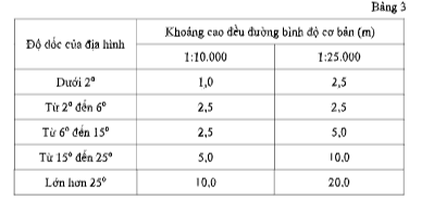
4. Within a map sheet, only one uniform interval for basic contour lines should be used, which is most suitable for the average slope or the main slope of the area. In cases where the slopes within the map sheet vary significantly, two uniform intervals for basic contour lines may be used, but this must be clearly stipulated in the Technical Design - Estimate.
5. Principal contour lines are basic contour lines shown with a heavier line weight for easier observation. When the basic uniform interval is 1.0 meters, 5.0 meters, or 10.0 meters, every fourth basic contour line is represented as a principal contour line (with elevations that are multiples of 5.0 meters, 25.0 meters, or 50.0 meters). When the basic uniform interval is 2.5 meters, every third basic contour line is represented as a principal contour line (with elevations that are multiples of 10.0 meters).
6. Half-interval contour lines are contour lines with elevations halfway between the basic contour lines. When the basic contour lines fail to adequately represent the characteristics of the terrain such as horseback saddles, low hills, stepped slopes, valleys, etc., and the distance between adjacent basic contour lines exceeds 2.0 cm on the map, half-interval contour lines or subsidiary contour lines must be added.
7. Subsidiary contour lines are contour lines with elevations between the basic contour lines and half-interval contour lines, used to depict special cases of sloping terrain that half-interval contour lines cannot clearly represent.
8. Sketch contour lines are contour lines with elevations equivalent to those of basic contour lines, used to indicate areas with unstable terrain heights such as sand dunes, mounds, etc., or where data reliability is insufficient.
9. Record the values of elevations for principal contour lines and subsidiary contour lines.
10. Slope indication lines are displayed only in places where it is difficult to determine the direction of the slope, such as mountain peaks, depressions, mountain ridges and ravines near the edges of the map sheet. Slope indication lines start perpendicular to the contour line indicating the slope and extend towards the lower ground, with their endpoints not intersecting any contour lines (to avoid confusion about the slope direction).
11. Elevation annotation points are shown on the map with an average density of 10 to 15 points per 1.0 dm². In flat areas with few contour lines, the density increases to 20 to 25 points per 1.0 dm².
For areas with many important objects requiring priority representation, such as densely populated regions and areas with numerous socio-economic objects, the density of elevation annotation points can be reduced, but not less than 8 points per 1.0 dm² in hilly areas and 10 points per 1.0 dm² in flat areas.
12. Elevation annotation points are selected for prominent locations such as road intersections, bends in river and canal banks, base points of orientation, mountain peaks, horseback saddles, basin bottoms, cave mouths, pit openings, etc. Elevation annotations are recorded in black whole numbers with a precision of 0.1 meters.
Special forms of terrain include erosion gullies, vertical slopes, landslides, landslip slopes, sliding slopes, rock faces, rocky mountains, stone walls, isolated rocks, gravel streams, volcanic craters, cave entrances, castellated terrain, mounds, various pits, terraced terrain, sand beaches, swamps, and are indicated according to the prescribed symbols.
14. Names of mountain ranges, mountain peaks, hills, passes, slopes, caves, and volcanic craters are annotated.
15. The contents of the topographic data layer categories are represented by corresponding symbols as set out in Section IV of Appendix 2 issued together with this Circular.
Article 13. Provisions on the Content of Traffic Data Layers
1. Traffic data layers reflect the traffic network and related works, including the road system, railway system, waterway system, bridges, traffic tunnels, ports, stations, and other traffic works.
2. The presentation of the traffic system must ensure the connectivity of the traffic network system, reasonable correlation with traffic works, and related technical infrastructure objects.
3. The road traffic system is presented according to management levels and technical grades, including expressways, national roads, provincial roads, district roads, commune roads, urban roads, and other types of roads.
4. Traffic routes with connectivity and lengths of 10.0 mm or more on the map for sparsely populated mountainous areas, and 20.0 mm for densely populated areas shall be depicted. Non-connected routes shall only be shown if they have lengths of 20.0 mm or more for sparsely populated mountainous areas, and 30.0 mm or more for densely populated areas. Routes related to national borders and administrative boundaries must be fully depicted.
5. All types of traffic bridges, floating bridges, suspension bridges, multi-level bridges, rotating bridges, and traffic tunnels must be fully represented.
6. Ferry routes, underground sections, and ferry lines must connect to the routes on both sides at ferry terminals and boat landing sites. Crossing points over rivers and streams in sparsely populated areas must be fully depicted.
7. Fully depict all traffic works: ports, stations, mooring basins, bus stops, parking lots, prioritizing those serving as hubs or connecting lines.
8. At locations where multiple intersecting traffic routes do not align at the same level (road intersections with overpasses, underpasses, etc.), objects must be depicted from a top-down vertical projection. In cases where objects completely overlap geometrically, the uppermost object must be fully depicted on the map, while lower objects must stop at the point of obstruction.
9. Fully depict all railway lines. Fully depict all signposts, tide stations, and coastal areas.
10. Embankments and cuttings of roads and railways with lengths of 30.0 mm or more on the map and heights or depths of 2.0 meters or more must be depicted along with annotations. Depict the toe of the embankment and cutting when the distance from the crest of the embankment or cutting on the map reaches 5.0 mm or more.
11. All types of bridges and ferries must be fully depicted with annotations. For vehicular bridges that can be crossed, their length, width, and load capacity must be depicted. Railway bridges do not require technical specifications to be annotated.
12. When the distance between the crest of the embankment and the traffic route on the map, scaled according to the ratio, is less than 0.2 mm, the crest of the embankment on the map may be shifted up to 0.2 mm to ensure distinguishability from the route symbol but must maintain correlation with adjacent objects.
13. Names of traffic objects shall be depicted as follows:
a) Roads at the district level and above;
b) Urban roads: names of streets and alleys with widths of 1.5 mm or more on the map;
c) Ferry terminals, long-distance ferry terminals, ferry stations, ship terminals;
d) Bridges, tunnels, ports, stations, mooring basins;
đ) Bus terminals, parking lots.
14. The contents of traffic data layers are depicted using corresponding symbols as specified in Section V of Appendix 2 issued together with this Circular.
Article 14. Provisions on the Content of Vegetation Cover Data Layers
1. The vegetation cover data layers reflect various types of natural plants and crops classified according to: the degree of development of the canopy, type of plant, group of plants, living environment of the plant (salt-tolerant, acid-saline...), distribution pattern (forest, sparse forest, tree belt, isolated trees...).
2. Areas of vegetation with an area of more than 15.0 mm² on the map shall be represented. For forest areas: When the area on the map is 1.0 cm² or larger, the symbol for the type of tree shall be shown; when the area on the map is 2.0 cm² or larger, the height of the trees shall be noted; when the area on the map is 4.0 cm² or larger, the name of the type of tree shall be noted.
3. In areas where multiple types of vegetation intermingle, priority shall be given to representing the dominant type of vegetation, but it must occupy at least 30% of the area. In cases where no type of vegetation meets this criterion, the mixed vegetation shall be represented according to the specified regulations.
4. Narrow strips of forests or tree belts with a width on the map under 1.5 mm and a length on the map of 10.0 mm or longer shall be represented; individual trees and clusters of individual trees that have significant directional significance in the area shall also be represented.
5. Boundaries of vegetation areas must be represented as closed boundaries. In cases where geographical linear features serve as vegetation boundaries, these features shall replace the corresponding sections of the vegetation boundary.
6. The specific names of all nature conservation areas and named forests shall be represented.
7. The contents of the vegetation cover data layers shall be represented using the corresponding symbols set forth in Section VI of Appendix 2 issued together with this Circular.
Article 15. Provisions on the Content of Hydrographic Data Layers
1. The hydrographic data layers reflect the system of rivers, streams, canals, ditches, seas, lakes, ponds, swamps, water sources, water edge lines, and other hydrographic objects.
2. Seas, natural rivers, lakes influenced continuously by rivers or tides (without human regulation) and large lakes must be depicted with their water edge lines and water edge lines according to the symbols.
3. When depicting rivers and streams, characteristics such as perennial flow, seasonal flow, difficult-to-determine sections, direction of flow, and tidal influence on the direction of flow must be shown.
4. Rivers, streams, canals, and ditches with a length on the map of 10.0 mm or longer must be depicted and must ensure the connectivity of the hydrographic network system consistent with the topography. Important rivers, streams, canals, and ditches related to borders and administrative boundaries must be fully depicted.
5. Ponds and lakes with an area on the map of 2.0 mm² or larger must be fully depicted according to scale. For ponds and lakes smaller than 2.0 mm² but located in water-scarce regions, they may be enlarged to 2.0 mm² to depict according to scale.
6. Waterfalls, rapids, riverbanks, floodplains, and shorelines must be fully depicted using the corresponding symbols.
7. Depict by scale for sandbars, banks, and sand in rivers and lakes with an area on the map of 1.0 mm² or larger. For sandbars, banks, and sand in rivers and lakes related to national border demarcation and administrative boundaries with an area on the map smaller than 1.0 mm², they must still be fully depicted.
8. Sandbars (floating, submerged) along rivers, lakes, and seas with an area on the map of 15.0 mm² or larger must be fully depicted. Islands in bays must be fully depicted using the corresponding symbols, without combining islands.
9. Hydrographic geographic objects including levees, dams, dikes, irrigation sluices, gates through dikes, water conveyance channels, and dike watchtowers must be depicted using the corresponding symbols.
10. Names of hydrographic objects shall be depicted as follows:
a) Rivers, streams, canals, and ditches with a length on the map of 10.0 cm or longer;
b) Ponds and lakes with an area on the map of 20.0 mm² or larger;
c) Floating, submerged, and half-floating-half-submerged sandbars along the coast with an area on the map of 20.0 mm² or larger;
d) Riverbank sandbars and sandbars within rivers with an area on the map of 20.0 mm² or larger;
đ) Levees, dikes, dams, and sluices on main rivers, canals, and ditches or those of significant importance;
e) Waterfalls and rapids;
g) Significant mineral water springs and hot springs.
11. Rivers, streams, canals, and ditches related to borders and administrative boundaries must be fully depicted with their names.
12. The contents of the hydrographic data layers shall be represented using the corresponding symbols set forth in Section VII of Appendix 2 issued together with this Circular.
Article 16. Symbols for national topographic maps at scales of 1:10,000 and 1:25,000
The symbols for national topographic maps at scales of 1:10,000 and 1:25,000 are detailed in Appendix 2 attached hereto. These symbols are designed and used according to the following principles:
1. The size of the symbols and annotations is calculated based on the size on the printed map at the correct scale of the map. The unit of measurement for symbol size is millimeters (mm). The unit of measurement for annotation font size is point (pt).
2. The size and line thickness of the symbols are noted next to the symbol. If the line does not indicate the line thickness, the assumed line thickness is 0.1 mm. For half-scale symbols, only the specified size for the non-proportional part is noted, while the rest is drawn at the map scale.
3. Uniformly distributed symbols, if no size is specified, should be drawn similarly to the model. When the area represented is less than 1.0 cm², the spacing between symbols may be reduced but not more than 70% of the spacing specified in the symbol model, ensuring clear distinction among component symbols and preventing them from resembling other types of symbols. The frame of uniformly distributed symbols is symbolic and not shown on the map, representing corresponding boundary features such as walls, fences, vegetation boundaries, and other linear geographic objects related to the area.
4. The symbols for national topographic maps at scales of 1:10,000 and 1:25,000 are designed in CMYK colors where C (Cyan) is light blue, K (Key) is black, M (Magenta) is dark pink, and Y (Yellow) is yellow. The colors of the symbols and color components are detailed in Appendix 1 attached hereto.
Chapter III IMPLEMENTATION PROVISIONS
Article 17. Effective Date
1. This Circular takes effect from November 30, 2020.
2. Decision No. 1126/ĐĐBĐ dated November 19, 1994 of the Director General of the National Land Administration issuing Symbols for Topographic Maps at Scales of 1:10,000 and 1:25,000 ceases to be effective from the date this Circular takes effect.
3. The contents stipulated in Clause 1.4, Section 1 General Provisions; Section 2 Mathematical Basis and Accuracy of Topographic Maps; and Section 3 Map Content in Decision No. 15/2005/QĐ-BTNMT dated December 13, 2005 of the Minister of Natural Resources and Environment regarding technical regulations for establishing topographic maps at scales of 1:10,000, 1:25,000, and 1:50,000 using digital image technology applicable to the establishment of topographic maps at scales of 1:10,000 and 1:25,000 cease to be effective from the date this Circular takes effect.
Article 18. Responsibility for Implementation
1. Ministries, ministerial-level agencies, government agencies, provincial people's committees, centrally governed cities, and relevant organizations and individuals are responsible for implementing this Circular.
2. During implementation, if there are difficulties, the agency, organization, or individual shall promptly report to the Ministry of Natural Resources and Environment for review and decision.
SIGNATURE OF THE MINISTER
DEPUTY MINISTER
(Signed)
Nguyen Thi Phuong Hoa
Văn bản gốc (PDF)
Bản đồ quan hệ
Bấm vào một văn bản để mở. Viền đỏ = quan hệ làm thay đổi hiệu lực.
Bản dịch
Văn bản này có sẵn ở các ngôn ngữ sau: