
This Circular details the procedures for creating land inventory maps and current land use maps, including mathematical bases, map scales, contents displayed on the maps, methods of compiling inventory data, and other technical requirements. It applies to all administrative levels from commune to national.
적용 범위
Administrative units from commune to national level in the creation of land inventory maps and current land use maps.
핵심 사항
- Provisions on the mathematical basis of the map
- Map scale for each administrative level
- Contents displayed on the map
- Methods of compiling inventory data
- Technical requirements for map creation
🌐 이 문서의 사회적 영향
- Enhance land management efficiency
- Provide detailed and updated information on land use conditions
- Support in making policy decisions related to land
❓ 자주 묻는 질문
How is the land inventory map created?
The land inventory map is created based on statistical data from commune-level administrative units, then compiled up to district, provincial, and national levels.
What is the scale of the current land use map?
The scale of the current land use map is specifically defined for each administrative level from 1/5000 to 1/250000 depending on requirements and terrain characteristics.
What contents are displayed on the current land use map?
The current land use map includes layers such as borders, administrative boundaries, water systems, transportation, socio-economic objects, and mathematical basis.
전문
CIRCULAR
Regulations on land statistics, inventory, and creation of current land use maps
and prepare a map of the current land use
_______________________
The Government issues this Decree on management and development of industrial clusters.
Pursuant to the Law on Statistics dated November 23, 2015;
Pursuant to the Law on Surveying and Mapping dated June 14, 2018;
Pursuant to the Law on Biodiversity dated November 13, 2008;
Pursuant to Decree No. 43/2014/NĐ-CP dated May 15, 2014 of the Government detailing implementation of certain provisions of the Land Law;
Pursuant to Decree No. 35/2015/NĐ-CP dated April 13, 2015 of the Government on management and use of rice fields;
Pursuant to the Decree No. 94/2016/NĐ-CP dated July 1, 2016 of the Government detailing and guiding the implementation of certain provisions of the Law on Statistics;
Pursuant to Decree No. 01/2017/NĐ-CP dated January 6, 2017 of the Government amending and supplementing certain decrees detailing the implementation of the Land Law;
On the basis of Decision No. 36/2017/NĐ-CP dated April 4, 2017, of the Government stipulating the functions, tasks, powers, and organizational structure of the Ministry of Natural Resources and Environment;
At the proposal of the Director General of the National Land Administration Department and the Head of the Legal Department,
The Minister of Natural Resources and Environment promulgates this Circular on land statistics, inventory, and creation of current land use maps.
PART I
GENERAL PROVISIONS
Article 1. Scope of Regulation
This Circular stipulates the time frame for implementation, indicators, forms, contents, methods, procedures, inspection, submission, storage of results of national land statistics, inventory, and creation of current land use maps; provincial and centrally-administered city levels; district, town, and provincial city levels; commune, ward, and town levels.
Article 2. Applicability
1. Ministry of Defense, Ministry of Public Security; state administrative agencies, specialized agencies on natural resources and environment at all levels; land administration officials at commune, ward, and town levels (hereinafter referred to collectively as commune-level land administration officials).
2. Land users, entities and individuals managing land on behalf of the State, and other organizations and individuals related to the implementation of land statistics, inventory, and creation of current land use maps.
Article 3. Purpose of land statistics and inventory
1. To assess the current situation of land management and use and propose measures to strengthen land management and improve land use efficiency.
2. To serve as a basis for planning and adjusting land use plans.
3. To provide a foundation for proposing adjustments to land policies and laws.
4. To supply data for compiling statistical yearbooks at various levels and to meet information needs for economic and social activities, national defense, security, scientific research, education and training, and other requirements of the State and society.
Article 4. Principles of Implementation of Land Statistics and Inventory
1. Types of land, types of land users, land managers, and other indicators must be consistent with the actual status at the time of statistics and inventory, except as provided in Clause 2 and Clause 4 of this Article.
2. In cases where there is a decision to allocate land, lease land, or permit changes in land use purposes but the land has not been used according to the decision at the time of statistics and inventory, it shall be inventoried according to the type of land and type of land user specified in the decision; simultaneously, it must also be inventoried according to the current use status in separate tables (Tables 05/TKDD and 05a/TKDD) for monitoring and management in accordance with land law regulations; except in cases where there is a decision to allocate or lease land but the land has not yet been physically handed over, it can still be inventoried according to the current use status.
3. In cases where the current land use purpose differs from that recorded in the land records, the inventory shall be conducted based on the current use status, while also conducting an inventory according to the purpose recorded in the land records and summarizing these cases in separate tables (Tables 06/TKDD and 06a/TKDD) for inspection, audit, and handling in accordance with legal provisions.
4. In cases of changing crop structures on rice fields as prescribed in Article 4 of Decree No. 35/2015/NĐ-CP dated April 13, 2015 of the Government on management and use of rice fields and Clause 11 of Article 2 of Decree No. 01/2017/NĐ-CP dated January 6, 2017 of the Government amending and supplementing certain decrees detailing the implementation of the Land Law, the inventory shall still be conducted according to the category of rice field land; simultaneously, the area of rice fields that have changed crop structures shall be inventoried in separate tables (Table 02a/TKDD).
5. In cases where land is being used for multiple purposes, in addition to inventorying according to the main land use purpose, additional inventorying shall also be conducted according to combined land use purposes in separate tables (Table 07/TKDD). The main land use purpose is determined in accordance with Article 11 of the Land Law and Article 3 of Decree No. 43/2014/NĐ-CP dated May 15, 2014 of the Government detailing certain provisions of the Land Law, which has been amended and supplemented in Clause 1 of Article 2 of Decree No. 01/2017/NĐ-CP dated January 6, 2017 of the Government amending and supplementing certain decrees detailing the implementation of the Land Law.
6. Periodic land inventory data is compiled from the results of surveys, delineation, and creation of land inventory maps for the entire area within the administrative boundaries of the inventory unit.
Annual land statistics data is compiled from land inventory maps that have been adjusted for cases of changes that have completed administrative procedures regarding land within the year of statistics in accordance with regulations.
7. The area of delineated land on commune-level land inventory maps is calculated in square meters (m2); the area data on land statistics and inventory tables is expressed in hectares (ha); figures are rounded to two decimal places (0.01 ha) for commune level, to one decimal place (0.1 ha) for district level, and to whole numbers (01 ha) for provincial and national levels.
Article 5. Time and Duration for Land Statistics
1. The time for annual land statistics is calculated up to December 31 of each year (except in the year of land inventory).
2. The duration for implementation and submission deadlines for annual land statistics reports are stipulated as follows:
a) People's Committee of communes, wards, towns (hereinafter referred to as People's Committee at commune level) shall implement from November 15 of each year (during the implementation period, they must continue to compile all cases of land changes until December 31); complete and submit the report results to the People's Committee of districts, cities under provinces (hereinafter referred to as People's Committee at district level) before January 16 of the following year;
b) People's Committee at district level shall complete and submit the report results to the People's Committee of provinces, centrally governed cities (hereinafter referred to as People's Committee at provincial level) before February 1 of the following year;
c) People's Committee at provincial level shall complete and submit the report results to the Ministry of Natural Resources and Environment before February 16 of the following year;
d) The Ministry of Natural Resources and Environment shall complete and report the results to the Prime Minister before March 16 of the following year;
đ) In case the implementation periods specified in points b and c of this clause coincide with the Tet holiday, the submission of the report results will be postponed by the number of days of the Tet holiday according to regulations.
Article 6. Time and Duration for Land Inventory and Preparation of Current Land Use Maps
1. The time for land inventory and preparation of current land use maps every five years is calculated up to December 31 of the year ending in 4 and 9.
2. The duration for implementation and submission deadlines for five-year land inventory and preparation of current land use maps are stipulated as follows:
a) People's Committee at commune level shall implement from August 1 of the inventory year (during the implementation period, they must continue to compile all cases of land changes until December 31); complete and submit the report results to the People's Committee at district level before January 16 of the following year;
b) People's Committee at district level shall complete and submit the report results to the People's Committee at provincial level before March 1 of the following year;
c) People's Committee at provincial level shall complete and submit the report results to the Ministry of Natural Resources and Environment before April 16 of the following year;
d) The Ministry of Natural Resources and Environment shall complete and report the results to the Prime Minister before June 16 of the following year;
đ) In case the implementation periods specified in points b and c of this clause coincide with the Tet holiday, the submission of the report results will be postponed by the number of days of the Tet holiday according to regulations.
3. The time and duration for special land inventory implementation shall be carried out according to the decision of the Prime Minister or the Minister of Natural Resources and Environment.
Article 7. Responsibilities for Implementation, Approval Authority, and Announcement of Results of Land Statistics, Land Inventory, and Preparation of Current Land Use Maps
1. Responsibilities for implementation, approval authority, and announcement of results of regular land statistics, land inventory, and preparation of current land use maps are as follows:
a) Commune-level land statistics, land inventory, and preparation of current land use maps are organized by the People's Committee at commune level; the commune-level land administration officer is responsible for assisting the People's Committee at commune level in implementation and signing confirmation on the land statistics, land inventory forms, and current land use maps of the commune; the Chairman of the People's Committee at commune level shall approve the land statistics, land inventory forms, current land use maps, and report results of land statistics and inventory of the commune to be sent to the People's Committee at district level;
b) District-level land statistics, land inventory, and preparation of current land use maps are organized by the Department of Natural Resources and Environment assisting the People's Committee at district level; the Director of the Department of Natural Resources and Environment signs confirmation on the land statistics, land inventory forms, and current land use maps of the district; the Chairman of the People's Committee at district level shall approve Form 01/TKDD - Regular Statistics and Inventory of Land Area, current land use maps, and report results of land statistics and inventory of the district to be sent to the People's Committee at provincial level;
c) Provincial-level land statistics, land inventory, and preparation of current land use maps are organized by the Department of Natural Resources and Environment assisting the People's Committee at provincial level; the Director of the Department of Natural Resources and Environment signs confirmation on the land statistics, land inventory forms, and current land use maps of the province; the Chairman of the People's Committee at provincial level shall approve Form 01/TKDD - Regular Statistics and Inventory of Land Area, current land use maps, and report results of land statistics and inventory of the province to be sent to the Ministry of Natural Resources and Environment;
d) The Land Registration Office and its Branches (hereinafter collectively referred to as the Land Registration Office) shall be responsible for taking the lead and coordinating with the Department of Natural Resources and Environment to review and compile land parcels that have completed administrative procedures during the land statistics and inventory period and send them to the People's Committee at commune level for land statistics and inventory (excluding commune-level units that have established land databases and are synchronized at all levels); at the same time, assist the Department of Natural Resources and Environment in conducting provincial-level land statistics and inventory;
đ) National-level land statistics, land inventory, and preparation of current land use maps are conducted by the General Department of Land Management assisting the Minister of Natural Resources and Environment; the Director of the General Department of Land Management signs confirmation on the national land statistics, land inventory forms, and current land use maps; the Minister of Natural Resources and Environment shall approve the report results of national land statistics and inventory to be submitted to the Prime Minister, who will issue a decision to announce the results of national land statistics and inventory;
e) Based on the actual situation regarding the application of technology and the professional capacity of cadres at various levels of localities, the Department of Natural Resources and Environment shall coordinate with the People's Committees of districts to establish a mechanism for cooperation and support between the Land Registration Office and the Department of Natural Resources and Environment and the People's Committee at commune level in implementing tasks related to land statistics, land inventory, and preparation of current land use maps to be approved by the People's Committee at provincial level.
The Department of Natural Resources and Environment shall direct specialized units responsible for land management, marine and island management, and environmental management under its jurisdiction to cooperate in conducting statistics and inventory of coastal land with surface water currently in use, natural conservation areas and biodiversity zones, and wetlands at the local level.
2. Responsibilities for implementation, approval authority, and publication of results of thematic land inventories are as follows:
a) The General Department of Land Management shall take the lead in organizing the implementation and compiling reports for approval by the Minister of Natural Resources and Environment and publication of the national thematic land inventory results, or submitting the report to the Minister of Natural Resources and Environment for approval by the Prime Minister and publication of the national thematic land inventory results. The Prime Minister shall approve and publish the results of the national thematic land inventory when such inventory is conducted pursuant to a decision of the Prime Minister.
b) Provincial People's Committees shall coordinate in organizing, directing, and implementing thematic land inventories at the local level according to plans and guidelines provided by the Ministry of Natural Resources and Environment.
3. Provincial People's Committees shall base on the actual situation of their locality to stipulate the engagement of consulting units to conduct statistics and inventories of land, prepare current land use maps in accordance with this Circular, ensuring quality and time requirements for implementation at the local level. The General Department of Land Management may engage consulting units to perform specific tasks within its responsibilities related to land inventories and preparation of current land use maps as prescribed.
Chapter II
STATISTICAL INVENTORY OF LAND AND PREPARATION OF CURRENT LAND USE MAPS ON A REGULAR BASIS
Section 1
SYSTEM OF INDICATORS, STATISTICAL FORMS, AND INVENTORIES OF LAND ON A REGULAR BASIS
Article 8. Indicators for statistical inventory of land on a regular basis regarding types of land
Types of land for statistical inventory are classified according to land use purposes and are divided from general to detailed levels as prescribed as follows:
1. Agricultural land group, including:
a) Agricultural production land comprising annual crop land and perennial crop land.
Annual crop land includes various types: Paddy field land (including dedicated paddy fields, remaining paddy fields, and upland paddy fields); other annual crop land (including flatland for other annual crops and upland for other annual crops).
b) Forestry land comprising productive forest land, protective forest land, and special-use forest land; which include natural forest land, planted forest land, and land currently being used for forest protection and development.
c) Aquaculture land;
d) Salt production land;
đ) Other agricultural land.
2. Non-agricultural land group, including:
a) Residential land comprising rural residential land and urban residential land;
b) Land for office building construction;
c) National defense land;
d) Security land;
đ) Land for public works construction comprising land for construction of organizational offices; cultural facilities; social service facilities; medical facilities; educational and training facilities; sports and physical education facilities; scientific and technological facilities; diplomatic facilities; and other public works construction land;
e) Non-agricultural production and business land comprising industrial zone land; industrial cluster land; export processing zone land; commercial and service land; non-agricultural production facility land; land for mineral activities; construction material and pottery production land;
g) Land for public purposes comprising transportation land; irrigation land; historical and cultural relic land; scenic spot land; community activity land; public entertainment land; energy project land; postal and telecommunications project land; market land; waste disposal land; and other public project land;
h) Religious facility land;
i) Belief facility land;
k) Cemetery land, burial ground land, funeral house land, crematorium land;
l) River, stream, canal, creek, and spring land;
m) Special-purpose water body land;
n) Other non-agricultural land.
3. Unused land group comprising flat unused land; hill and mountain unused land; rock mountains without trees.
4. Coastal land with surface water comprising aquaculture coastal water land; mangrove coastal water land; and coastal water land used for other purposes.
5. Interpretation and guidance for the statistical inventory of each type of land shall be carried out in accordance with Appendix No. 01 attached to this Circular.
Article 9. Statistical and inventory indicators for periodic land statistics on types of land users and types of entities managed by the State
1. Statistical and inventory indicators for land regarding types of land users include:
a) Households and individuals within the country;
b) Domestic organizations, including:
- Economic organizations (including enterprises and cooperatives);
- State agencies comprising state agencies (including People's Committees at commune level); political organizations, political-social organizations; defense and security units;
- Public service organizations established by competent state agencies, political organizations, or political-social organizations with functions to perform public service activities as prescribed by law;
- Other organizations including social organizations, social-professional organizations, and other organizations (excluding state agencies, public service organizations, and economic organizations);
c) Foreign organizations and individuals, including:
- Foreign-invested enterprises comprising wholly foreign-owned enterprises, joint ventures, Vietnamese enterprises where foreign investors hold shares, mergers, or acquisitions according to laws on investment;
- Foreign organizations with diplomatic functions comprising diplomatic missions, consular offices, other foreign representative offices with diplomatic functions recognized by the Government of Vietnam; representative offices of United Nations organizations, intergovernmental organizations, or representative offices of intergovernmental organizations;
- Foreign individuals owning houses in Vietnam according to laws on housing;
d) Overseas Vietnamese residents comprising cases where overseas Vietnamese residents own houses attached to residential land rights; overseas Vietnamese-owned enterprises; additionally, statistical and inventory records are made for joint ventures between overseas Vietnamese residents and domestic economic organizations or Vietnamese enterprises where foreign investors contribute capital through land use rights of domestic organizations or individuals to implement investment projects in Vietnam;
đ) Community and religious establishments, including:
- Community comprising Vietnamese communities living in the same village, hamlet, ward, commune, tribe, village, group, or similar settlement with common customs and traditions, or Vietnamese communities sharing the same lineage granted land by the State or recognized land use rights, inheritance, or gifts of land use rights for preserving national identity, such as land for communal houses, temples, shrines, hermitages, ancestral halls, family shrines;
- Religious establishments comprising temples, churches, chapels, sanctuaries, meditation halls, monasteries, specialized training institutions of religions, headquarters of religious organizations, and other religious facilities permitted by the State to operate.
2. Statistical and inventory indicators for land regarding types of entities managed by the State include:
a) People's Committees at commune level entrusted by the State to manage land comprising: unallocated land, unleased land; land for constructing public works directly managed by People's Committees at commune level (rural roads, irrigation works within communes; squares, monuments, memorials in communes and towns); rivers and streams within communes; dedicated water surfaces without users; agricultural land reclaimed by the State from households and individuals in rural areas under Clause 1, Article 64, and Points a, b, c, and d, Clause 1, Article 65 of the Land Law;
b) Land development funds entrusted by the State to manage land reclaimed by the State according to land laws;
c) Communities and other organizations entrusted by the State to manage land, including:
- Communities entrusted by the State to manage forest land for protecting and developing forests according to forestry laws;
- Organizations entrusted by the State to manage land with public works comprising roads (in urban areas and inter-commune roads), bridges, culverts, sidewalks, water supply systems, drainage systems, dedicated water surfaces in urban areas; hydropower systems, dykes, dams, inter-commune rivers and streams; squares, monuments, memorials managed by county and provincial levels; uninhabited islands; organizations entrusted by the State to manage land to implement investment projects under build-transfer (BT) form.
3. The explanation and guidance for statistical and inventory records for each type of land user and entity managed by the State shall be implemented according to Appendix No. 01 attached to this Circular.
Article 10. Statistical indicators for periodic land inventory by region
1. Rural residential land: Inventory all types of land within areas primarily designated for constructing houses, public facilities serving daily life and activities of residents; garden and pond land attached to houses and other types of land within the boundaries of rural residential areas in commune administrative territories, excluding new urban areas as specified in Clause 5 of this Article.
The boundaries of rural residential areas are determined according to land use plans or rural residential area construction plans approved by competent authorities; in cases where rural residential areas have not been approved with planning, the boundaries are determined based on the boundaries of the outermost residential plots in villages, hamlets, wards, villages, clusters, settlements, and similar populated points.
For cases where residents live along canals, ditches, roads, or scattered residents in areas without planning or outside the approved rural residential area planning boundaries, only the area of residential plots with houses and attached gardens and ponds will be inventoried; if the boundaries of residential land and attached gardens and ponds cannot be determined, only the recognized residential land area will be inventoried; in cases where the residential plot has not been issued a land use right certificate, the temporary residential land area will be determined by the new residential land allocation limit set by the provincial People's Committee.
2. High-tech industrial zone land: Inventory all types of land within high-tech industrial zones established by the Prime Minister's decision for purposes of producing high-tech products, researching and applying high technology, and training high-tech human resources. The Prime Minister for use in serving high-tech production and business purposes, high-tech research and application, and high-tech human resource training.
3. Economic zone land: Inventory all types of land within economic zones and border economic zones established by the Prime Minister's decision, which have been allocated by state agencies with authority to the management boards of economic zones for managing and allocating land, leasing land for purposes of building duty-free zones, bonded warehouses, export processing zones, industrial parks, entertainment zones, tourist zones, urban zones, residential zones, administrative zones, and other functional zones suitable for each economic zone. The Prime Minister, who has been assigned land by competent state authorities to the Management Board of the economic zone for management and reassignment, leasing the land for use in constructing duty-free zones, bonded warehouses, export processing zones, industrial parks, entertainment areas, tourist areas, urban areas, residential areas, administrative areas, and other functional zones appropriate to the characteristics of each economic zone.
4. High-tech agricultural zone land: Inventory areas and projects using land for agricultural production applying new and advanced technologies, including: industrialization (mechanization), automation of production processes; application of information technology and biotechnology in breeding, production, preservation, and processing of agricultural products to achieve high economic efficiency per unit area and sustainable development based on organic farming.
5. Urban land: Statistics and inventory all types of land within the administrative boundaries of wards and towns; new urban areas that have actually formed within the development planning scope of districts, townships, and cities under provinces, as approved by competent authorities.
6. Natural conservation area land: Inventory land within natural conservation areas (including national parks, nature reserves, species and habitat conservation areas, scenic protection areas) established by the Prime Minister's or Provincial People's Committee Chair's decisions. The Prime Minister, the Chairman of the People's Committee of the province.
7. Biodiversity conservation facility land: Inventory land within facilities caring for, breeding, rescuing, and propagating wild species, crops, livestock, microorganisms, and endemic fungi of value; preserving and storing genetic sources and genetic samples for biodiversity conservation and development purposes.
8. Wetland land: Inventory land within marshes, peatlands, and other regularly flooded lands or seasonal wetlands; including coastal areas with depths not exceeding six meters at low tide being used for agricultural, non-agricultural, and natural conservation purposes.
Article 11. Total land area index for administrative units in periodic land statistics and inventory
1. The total land area index for administrative units is determined to include the entire area of all types of land within the territorial boundaries of each administrative unit as defined by law.
2. For administrative units adjacent to the sea, the area of such administrative units includes the area of all types of land on the mainland and islands at sea (if any), calculated up to the lowest average low-water mark over many years; if the lowest average low-water mark over many years cannot be determined, it shall be based on the lowest low-water mark at the time of inventory. Coastal water areas outside the lowest average low-water mark over many years that are being used for various purposes shall be separately inventoried and not included in the total area of the administrative unit.
3. For areas with disputes or inconsistencies regarding administrative boundaries, the following principles shall be followed for inventory and statistics:
a) In cases where there is no dispute over administrative boundaries but there is inconsistency between the actual administrative boundary lines managed on-site and those shown on approved administrative boundary maps, the total land area of the administrative unit shall be inventoried and statistically recorded according to the actual administrative boundary lines currently managed.
b) In cases where there is a dispute over administrative boundaries, the following shall be implemented:
- The locality temporarily managing the disputed area shall be responsible for organizing the inventory and statistics of land in the disputed area; in cases where both parties recognize themselves as managing the disputed area, they shall agree for one party to carry out the inventory and statistics or for both parties to jointly conduct the inventory and statistics of the disputed area.
- The area of the disputed administrative boundary shall not be included in the total land area of the administrative units involved in the dispute but shall be compiled separately by type of land and type of land user, and clearly stated in the report on the results of the land inventory and statistics of the locality. This disputed area's area shall be included in the total area of the higher-level administrative unit.
Article 12. System of statistical and inventory forms for periodic land
1. The system of statistical and inventory forms for periodic land includes:
a) Form 01/TKDD - Periodic Statistics and Inventory of Land Area: Applied in periodic land statistics and inventory to compile data comprehensively for agricultural land, non-agricultural land, unused land, and coastal water areas being used for various purposes.
b) Form 02/TKDD - Periodic Statistics and Inventory of Agricultural Land Area: Applied in periodic land statistics and inventory to compile data for detailed types of agricultural land; in cases where land is used for multiple purposes, this form only compiles according to the main purpose of land use.
Form 02a/TKDD - Periodic Inventory of Rice Cultivation Land Area Converted According to Regulations: Applied in periodic land inventory to compile data for rice cultivation land that has been converted according to regulations stipulated in Article 4 of Decree No. 35/2015/NĐ-CP and Clause 11 of Article 2 of Decree No. 01/2017/NĐ-CP.
c) Form 03/TKDD - Periodic Statistics and Inventory of Non-Agricultural Land Area: Applied in periodic land statistics and inventory to compile data for detailed types of non-agricultural land; in cases where land is used for multiple purposes, this form only compiles according to the main purpose of land use.
d) Form 04/TKDD - Periodic Statistics and Inventory of Land Area Classified by Administrative Units: Applied in periodic land statistics and inventory to compile data on land area classified by lower-level administrative units directly under the level conducting the statistics and inventory (including district, provincial, regional, and national levels).
đ) Form 05/TKDD - Periodic Statistics and Inventory of Land Already Allocated, Leased, or Changed Purpose But Not Yet Implemented: Applied in periodic land statistics and inventory to compile data for cases where decisions have been made and land has been allocated, leased, or permission granted to change land use purpose, but at the time of statistics and inventory, the land has not yet been used according to the decision. The purpose of land use in this form is compiled into two categories: land according to the purpose allocated, leased, or permitted to change land use purpose by the State, and land according to the current usage status.
Form 05a/TKDD - Compilation of Cases Allocated, Leased, or Changed Purpose But Not Yet Implemented: Applied in periodic land statistics and inventory to list cases where land has been allocated, leased, or changed purpose but not yet implemented.
e) Form 06/TKDD - Periodic Inventory of Land Changed Purpose Differing from Land Registry Records: Applied in periodic land inventory to compile data for cases where the current land use purpose has changed compared to existing land rights documents and managed land registry records, including cases where administrative procedures related to land have been completed but the land registry records have not yet been updated. The purpose of land use in this form is compiled into two categories: land according to the land registry records and land according to the current usage status.
Form 06a/TKDD - List of Cases Where Land Use Purpose Has Changed Differing from Land Registry Records: Applied in periodic land inventory to list cases where the current land use purpose has changed compared to existing land rights documents and managed land registry records, including cases where administrative procedures related to land have been completed but the land registry records have not yet been updated.
g) Form 07/TKĐĐ - Periodic Inventory of Land Area Used for Multiple Purposes: Applied in periodic land inventory to summarize for parcels of land primarily used for main purposes (including rice fields, perennial crop land, forestry land, residential land, defense land, security land, water conservancy land, energy project land, river, stream, canal, creek, spring and specialized water surface) that are also used for other purposes (agriculture production, forestry, aquaculture, or non-agricultural production and business);
h) Form 08/TKĐĐ - Periodic Inventory of Land Area in Nature Reserves and Biodiversity Conservation Areas: Applied in periodic land inventory to summarize according to types of land and land users in nature reserves and biodiversity conservation facilities;
i) Form 09/TKĐĐ - Periodic Inventory of Wetland Land Area: Applied in periodic land inventory to summarize according to types of land and land users with regular or seasonal flooding;
k) Form 10/TKĐĐ - Periodic Inventory of Land Area in Comprehensive Zones: Applied in periodic land inventory to summarize land area according to types of land within comprehensive zones;
l) Form 11/TKĐĐ - Statistics and Periodic Inventory of Urban Land Area: Used at district, provincial, and national levels to compile statistics and periodic land inventory data for urban land as stipulated in Clause 5, Article 10 of this Circular;
m) Form 12/TKĐĐ - Analysis of Reasons for Increase or Decrease in Land Area: Applied to analyze reasons for increase or decrease in land area according to land use purposes during the statistical and inventory period;
n) Form 13/TKĐĐ - Structure of Land Area According to Land Use Purpose and Land Users: Applied in periodic statistics and inventory of land to calculate the structure of land area according to land use purpose and land users and managers of Form 01/TKĐĐ;
o) Form 14/TKĐĐ - Changes in Land Area According to Land Use Purpose: Applied in periodic statistics and inventory of land to calculate the increase or decrease in land area due to changes in land use purpose based on data from Form 12/TKĐĐ. For statistical data, compare with data from the previous statistical period and the most recent inventory period; for inventory data, compare with data from the two most recent inventory periods;
p) Form 15/TKĐĐ - Comparison of Current Land Use Status and Land Use Plan: Applied in periodic statistics and inventory of land to compare current land use status with the land use plan for the statistical and inventory year and compare the land area converted for use during the statistical and inventory period with the planned land area conversion approved in the land use plan;
q) Form 16/TKĐĐ - Statistics and Periodic Inventory of Defense and Security Land Area: Applied in periodic statistics and inventory of land to summarize types of land currently used in defense and security areas;
2. Content, code symbols of indicators, and formats of land statistics and inventory forms shall be implemented in accordance with Appendix No. 02 attached to this Circular;
3. Forms 01/TKĐĐ, 02/TKĐĐ, and 03/TKĐĐ prescribed in Clause 1 of this Article, in addition to being used to conduct statistics and inventory of the entire area within administrative boundaries, are also used to conduct statistics, inventory, and report separately on the area of land in administrative boundary dispute zones as stipulated in Point b, Clause 3, Article 11 of this Circular;
Section 2
IMPLEMENTATION CONTENT OF LAND STATISTICS AND PERIODIC INVENTORY AND ESTABLISHMENT OF CURRENT LAND USE STATUS MAPS
Article 13. Contents of Periodic Land Statistics Implementation
1. Collecting files, documents, maps, and data related to land changes during the statistical period; data from land inventory or land statistics conducted in the previous year.
2. Reviewing, updating, and adjusting land changes on the land inventory map.
3. Processing and consolidating data into land statistics tables at various levels as prescribed.
4. Analyzing, evaluating the current land use status, land changes, and proposing solutions to enhance management and improve land use efficiency.
5. Preparing land statistics reports.
6. Approving, printing copies, and issuing land statistics results.
Article 14. Contents of Periodic Land Inventory Implementation and Current Land Use Status Map Preparation
1. Collecting files, documents, maps, and data related to land changes during the inventory period; results of the previous land inventory and annual statistics results during the inventory period; preparing maps for inventory surveys.
2. Surveying, delineating, or adjusting land parcels according to inventory criteria to create land inventory maps; calculating the area of each parcel and compiling the List of Land Parcels for Statistics and Inventory as stipulated in Appendix No. 03.1 attached hereto.
3. Processing and consolidating data to compile land inventory tables as prescribed for each administrative level; preparing explanatory reports on current land use status.
4. Creating current land use status maps at various levels; preparing explanatory reports on current land use status maps.
5. Analyzing and evaluating the current land use status, land change situation during the inventory period; proposing solutions to enhance management and improve land use efficiency.
6. Preparing land inventory result reports and creating current land use status maps.
7. Approving, printing copies, and issuing land inventory results and current land use status maps.
Article 15. Reports on Results of Periodic Land Statistics and Inventories
1. The contents of the Report on Land Statistics Results include:
a) Implementation organization situation, data sources, and materials used for land statistics consolidation at the commune level and evaluation of the reliability of collected materials and data;
b) Evaluation of the current land use status; assessment of the land use change situation and analysis of reasons for land use changes between the statistical year and the previous year's statistics and inventory data; assessment of the implementation of the annual land use plan; situations of land allocation, land leasing, permission for land use purpose conversion but not yet implemented; disputes and resolution of administrative boundary disputes during the statistical period (if any);
c) Proposing measures to strengthen land management.
2. The contents of the Report on Land Inventory Results include:
a) Implementation organization situation; survey methods, data collection for land inventory, origin of data collected at the commune level and evaluation of the reliability of collected data and consolidated data; other information related to data; sources of materials and methods for creating current land use status maps;
b) Analysis and evaluation of the current land use status according to inventory criteria; assessment of the land use change situation and analysis of reasons for land use changes between the inventory year and the two most recent inventory periods; assessment of the implementation of land use purpose conversion planning and plans during the land inventory period; situations of land allocation, land leasing, permission for land use purpose conversion but not yet implemented; situations and reasons for land use purpose conversion different from the land administration records; situations of rice field structure conversion; wetland situations; disputes and resolution of administrative boundary disputes during the inventory period (if any);
c) Proposing measures to strengthen land management and use.
Section 3
METHODS AND PROCEDURES FOR PERIODIC LAND STATISTICS IMPLEMENTATION, LAND INVENTORY IMPLEMENTATION, AND CURRENT LAND USE STATUS MAP PREPARATION
Article 16. Method for Implementing Periodic Land Statistics
1. The land statistics at the commune level shall be carried out based on reviewing and comparing the summary table of cases of land changes that have completed administrative procedures related to land within the year of statistics (provided by the Land Registration Office and transferred according to Model 03.2 attached to this Circular) with the actual land use to update and amend the land inventory map and compile land statistics data.
2. The compilation of land statistics data at various levels, economic-social regions, and nationwide shall be conducted using electronic computers with statistical and inventory software provided by the Ministry of Natural Resources and Environment.
3. For communes that do not yet have conditions to update and amend the digital land inventory map, the People's Committee at the commune level shall review and compare the summary table of cases of land changes that have completed administrative procedures related to land within the year of statistics (provided by the Land Registration Office and transferred) with the actual land use; confirm the current status of land use for each plot of land into the summary table of cases of land changes and send it back to the Department of Natural Resources and Environment to carry out the updating and amending of the digital land inventory map and compile land statistics data using the land inventory software.
4. The updating and amending of delineation on the land inventory map regarding boundaries, types of land, types of land users, and land managers shall be done through the method of transferring drawings, updating, and amending from the files of completed administrative procedures related to land, ensuring the requirements stipulated in Clauses 2, 5, and 6 of Article 17 of this Circular.
Article 17. Method for Implementing Periodic Land Inventory
1. The land inventory at the commune level shall be carried out based on surveying, delineating, and amending plots of land according to the types of land, types of land users, and land managers specified in Articles 8, 9, and 10 of this Circular onto the map designated for the survey and inventory as stipulated in Clause 3 of this Article. The results of the delineation and amendment shall be compiled into a land inventory map at the commune level for compiling land inventory data and creating a current land use status map.
2. The land inventory map at the commune level shall be defined as follows:
a) Mathematical basis of the land inventory map: established in the national coordinate system VN-2000, using a transverse cylindrical equal-angle projection with a scale adjustment factor ko = 0.9999 for the meridian axis of each province and centrally-administered city as specified in Appendix 04 attached to this Circular;
b) Content of the land inventory map includes the following groups of objects:
- Boundaries and symbols of delineated plots according to inventory criteria;
- National borders and administrative boundary lines at various levels;
- Hydrographic features and related objects including sea, lake, pond, reservoir, excavated pool, river, stream, canal, creek, and other hydrological objects;
- Transportation and related objects including railway works, all types of roads at various levels (including intra-field roads, roads within residential areas, and footpaths in mountainous and midland communes) and transportation works along those roads;
- Economic and social elements showing names of place names, offices of authorities at various levels; names of infrastructure works and other objects;
- Topographic elements (points of elevation, annotations of elevation) and other contents of the map used for survey and inventory (if applicable, excluding plot boundaries);
- Notes and explanations;
- Map frame, orthogonal coordinate grid;
c) Delineations on the land inventory map must meet the following requirements:
- The boundaries of delineated plots must be closed and transferred from the map used in the survey and inventory with the highest accuracy, without summarizing or generalizing;
- Labels of delineated plots must include the plot number; area of the delineated plot; land type code; land user type code or land manager type code in the following format:

- In cases where a delineated plot is used for multiple purposes throughout its entire area, the main land type code should be shown first, followed by secondary land type codes in parentheses: Main land type code (Secondary land type code 1; secondary land type code 2;...); if the secondary land type only occupies part of the plot area, then the area of the secondary land type should also be indicated: Main land type code (Secondary land type code 1: area of secondary land type 1; Secondary land type code 2: area of secondary land type 2;...);
- If a delineated plot has multiple uses and the area used for each purpose can be determined (such as a residential area with both residential and agricultural land), then the codes of each land type and their respective areas should be indicated in parentheses: Land type code 1 (area of land type 1); Land type code 2 (area of land type 2);...;
- If a delineated plot has multiple land user types or land manager types throughout its entire area, the code of the most numerous type should be indicated; if the area of each type can be determined (such as a delineated agricultural plot with both household and communal land), then the codes of each type and their respective areas should be listed sequentially: Object type code 1 (area of object type 1); Object type code 2 (area of object type 2);...;
- For delineated plots in areas transitioning from paddy fields to other types of land, the code of the post-transition land type as specified in Table 02a/TKDD should be added to an appropriate position within the delineated plot. If the transition occurs on only part of the plot area, the transition area should also be indicated: Post-transition land type code: transition area. If the transition is from paddy fields to multiple types of land, the transition areas should be indicated separately: Post-transition land type code 1: transition area 1; Post-transition land type code 2: transition area 2;...;
- For land plots within areas that need to be surveyed according to Tables 08/TKDD, 09/TKDD, and 10/TKDD, the code of the general area should be added to the appropriate position within the land plot. In cases where only part of the land plot falls within such a general area, it should be shown as follows: General Area Code: Area within the general area. If a land plot belongs to multiple general areas, the code for each general area should be shown separately.
- The label for the land plot can be created in the form of a cell or text. The code symbol for land type, land user category, and land management subject shall be as prescribed in Appendix No. 04 issued together with this Circular.
-The serial number of the land plot shall be indicated using Arabic numerals from 01 to the end within the entire commune, numbered from left to right, top to bottom, in a zigzag pattern. For elements occupying land that do not form a closed land plot but are delineated along administrative boundaries and are numbered like land plots.
d) Water systems, transportation objects, and other related objects shall show the boundary of land occupied by each object and the object label as stipulated in point c of this Clause.
3. Types of maps and data used for land survey and inventory at the commune level are specified as follows:
a) Using land survey maps established previously and updated annually. For the 2019 land survey, the map results of the 2014 land survey shall be used, updated annually if there are changes.
b) Where there is a land database built after the previous land survey map was established, the land database shall be used for the survey and inventory.
c) Where there is no land database but there is a cadastral map established after the previous land survey map was established, the new cadastral map shall be used for the survey and inventory.
d) Where the previous land survey map was not based on a cadastral map and does not have sources of information as stipulated in points b and c of this Clause, the following sources of information shall be used (if available): newly established orthophotos not older than two years before the survey date, adjusted to the mathematical basis of the required land survey map; spatial land data; national geographic database; newly established topographic maps with a scale larger than or equal to the previous land survey map's scale to update the previous land survey map.
4. Processing and consolidating various sources of maps and data to serve the survey, delineation, and establishment of land survey maps:
a) Where the sources of maps and data as stipulated in point d of Clause 3 of this Article are used, they shall be reviewed, updated, and supplemented with changed contents from these sources into the previous land survey map to serve the survey and inventory.
When using orthophotos, the delineation of land plot boundaries and related land-occupying objects with clear images according to the requirements of the land survey map shall be conducted, and the updates and corrections shall be made to the previous land survey map; in case of discrepancies between the image and the land survey map, corrections shall be made according to satellite images or aerial photographs, retaining the raster background image for the survey and delineation.
b) Reviewing and updating the delineation of land plots and related objects with changes from land allocation, lease, recovery, change of land use purpose, and land registration records (as summarized by the Land Registration Office), forestry survey records of the agriculture sector, and rice land databases established during the previous survey period.
c) Where the sources of maps and data as stipulated in points b and c of Clause 3 of this Article are used, the land parcels shall be compiled into land plots according to the provisions of Clause 1 of this Article for the survey and inventory. Where the locality has cadastral maps at different scales, they shall be compiled to match the scale of the required land survey map.
d) Reviewing the boundaries and administrative boundaries on the map used for the survey and inventory to align them with the latest approved and published boundary maps and administrative boundary maps.
Where there is inconsistency between the actual managed administrative boundary and the administrative boundary records, the actual managed administrative boundary shall be reflected on the map used for the survey and inventory. Where there is a dispute over the administrative boundary, the disputed administrative boundary according to the opinions of the parties involved shall be reflected on the map used for the survey and inventory.
The representation of administrative boundaries at various levels on the map used for the land survey and inventory must meet the requirements for automation in calculating and reporting the area of various types of land, allowing verification of statistical data consistency from the commune to provincial, regional, and national levels. Where administrative boundaries overlap, the highest-level administrative boundary shall be prioritized.
5. The investigation, delineation, and adjustment of boundaries of land plots and other land-occupying objects on-site shall be carried out as follows:
a) Comparing the boundaries, land types, land user categories, and land management subjects of land plots and related land-occupying objects through correlation between the map and the field to identify cases requiring additional delineation and map adjustments to reflect current conditions.
Where it is necessary to delineate, adjust boundaries, or divide land plots, the method of intersection or perpendicular coordinates from clearly marked points on-site already shown on the map shall be applied; the determination of the length of the intersecting edge or perpendicular edge may be measured with a tape measure or other equivalent precision measuring tools.
b) The boundaries of land occupied by water systems and transportation objects shall be delineated and adjusted according to the following requirements:
- The boundaries of water conservancy and transportation works are delineated according to the toe line of the slope (for embankment works) or the crest line of the slope (for excavation works);
- The boundaries of natural hydrological objects (lakes, rivers, streams, canals, brooks) are delineated according to the top edge of the sliding face of the hydrological object; in cases where hydrological objects have retaining walls, the boundary of the hydrological object is delineated according to the outer toe of the retaining wall;
c) The coastline is delineated according to the lowest edge of the sea water level over many years; in cases where the lowest edge of the sea water level over many years cannot be determined at the time of inventory, it is delineated according to the lowest edge of the sea water level at the time of inventory;
6. The preparation of land inventory maps at the commune level shall be carried out as follows:
a) Land inventory maps are prepared in digital form based on the results of field surveying and delineation as prescribed in Clause 5 of this Article;
b) In cases where the map used for inventory does not have an original digital version, the content elements of the used map are scanned and digitized, integrated, and processed to prepare a digital land inventory map;
c) In cases where the boundaries of delineated land parcels are determined by intersection methods or orthogonal coordinates on-site, they are transferred to the digital map using one of the following methods: scanning and digitizing the content elements delineated outside the site or calculating the coordinates of the vertices of the delineated land parcels and transferring them to the map by entering the coordinates of the points or constructing shapes using intersection methods or orthogonal coordinates;
d) Information on land inventory maps is organized into layers, wherein the boundaries of delineated land parcels within the same set of criteria are defined in the same layer of information. The classification of information layers for land inventory maps is implemented according to the regulations on the classification of current land use maps in Appendix No. 04 attached hereto;
đ) The accuracy of digitization, transfer, and delineation of content elements of land inventory maps shall be carried out as follows:
- Digitized maps must ensure that the size errors of the inner frame edges of the map after alignment do not exceed 0.2 mm and the diagonal does not exceed 0.3 mm according to the scale of the map;
- The mutual error of transferring delineated land parcels shall not exceed ±0.5 mm according to the scale of the current land use map;
- The error of transferring the positions of current land use content elements shall not exceed ±0.3 mm according to the scale of the current land use map;
e) The preparation of land inventory maps in digital form shall be carried out as follows:
- The *.dgn format file of the land inventory map of the Microstation software, accompanied by the source symbol file and map history file; the file must be in an open format, allowing for editing and updating information when necessary and having the ability to convert formats; Vietnamese character fonts, Unicode code tables; independent symbol libraries pre-created in the "HT" library for corresponding scale series named ht1-5.cell, ht10-25.cell, ht50-100.cell, ht250-1tr.cell, etc.; symbol libraries for linear patterns according to scale series named ht1-5.rsc, ht10-25.rsc, ht50-100.rsc, ht250-1tr.rsc, etc.; color palette named ht.tbl;
- The parameters of the standard map file (seed file) include: Measurement Unit (Working Units); main working unit (Master Units) is meters (m); secondary working unit (Sub Units) is millimeters (mm); resolution (Resolution) is 1000; coordinates of the center point for work (Storage Center Point/Global Origin) are X: 500000 m, Y: 1000000 m;
- Objects in the form of lines (one of the forms Line String, Chain, Complex Chain, or Polyline, etc., according to the editing software) must be continuous without interruption and may only stop at nodes where lines representing objects of the same type intersect;
- Objects in the form of areas (one of the forms pattern, shape, complex shape, or fill color, etc., according to the editing software) must be closed areas; - Symbol objects in the form of points (in the form of cells according to the editing software) must be represented by predefined point symbols in the *.cell files;
- Objects on digital land inventory maps must be correctly displayed in their respective layers and with accompanying parameters as specified in the table of object classifications. For objects participating in closing areas of delineated land parcels drawn at a ratio (such as roads, administrative boundaries, etc.), the original state of the participating parts should be preserved and transferred to a separate layer to participate in closing areas;
7. The calculation of the area of delineated land parcels and non-parcel occupying objects shall be carried out as follows:
On land inventory maps, objects requiring area calculation (land parcels, non-parcel occupying objects) must be enclosed into regions and spatial relationships (topology) must be established;
In cases where region-type objects of the same kind (same type of traffic or hydrological objects, etc.) intersect at the same level, the object is calculated according to the outermost land occupation boundary. In cases where region-type objects are of different kinds (different types of traffic or hydrological objects) or of the same kind but intersect at different levels, the area of the overlapping part of the vertical projections of these objects on the ground surface is calculated for the object directly on the ground surface;
The area of delineated land parcels is calculated using analytical methods on digital maps and is summarized for comparison with the total area of the commune administrative unit calculated using analytical methods along the administrative boundary; in cases where there is a discrepancy in the area between the data from the delineated land parcels and the data calculated along the administrative boundary, verification and handling of duplicate or omitted cases must be conducted;
The results of the area calculation of delineated land parcels are compiled into a list of delineated land parcels showing the information: parcel number, parcel area, attributes of the delineated parcel corresponding to the land inventory criteria as prescribed;
8. The method of compiling inventory data shall be carried out as follows:
a) Commune-level inventory data is compiled from the list of delineated land parcels of the land inventory conducted using unified software of the Ministry of Natural Resources and Environment.
For inventory indicators that are surveyed using direct survey forms or other specialized inventory methods attached to periodic inventories but cannot be compiled using software, traditional calculation tools shall be used for compilation, with specific provisions set forth for each inventory period.
b) Inventory data at the district, provincial, economic and social region, and national levels shall be compiled from the inventory data of subordinate administrative units using a unified software program of the Ministry of Natural Resources and Environment.
Article 18. Preparation of Land Use Status Maps
1. Land use status maps shall be prepared for each administrative level, economic and social regions, and nationwide to reflect the distribution of land types at the time of land inventory.
2. Commune-level land use status maps shall be established based on the synthesis and generalization of the content of land inventory maps.
District and provincial land use status maps shall be prepared based on the connection, compilation, and generalization of the content of commune-level land use status maps.
Economic and social region land use status maps shall be prepared based on the compilation and generalization of the content of provincial land use status maps.
National land use status maps shall be prepared based on the compilation and generalization of the content of economic and social region land use status maps.
3. The mathematical basis of land use status maps is specified as follows:
a) Commune, district, and provincial land use status maps shall be implemented according to the provisions of point a, Clause 2, Article 17 of this Circular.
b) Economic and social region land use status maps shall use a transverse cylindrical projection with a standard meridian of 60 and a scale factor of 0.9996.
c) National land use status maps shall use a conical projection with standard parallels of 110 and 210, and a central meridian of 108 for the entire territory of Vietnam.
4. The scale of land use status maps at various levels shall be established as follows:
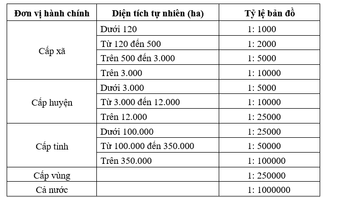
In cases where administrative units establish land use status maps with special shapes (length much greater than width), they may choose a larger or smaller scale by one degree compared to the above regulations.
5. The content of land use status maps is specified as follows:
a) The group of mathematical basis classes and related contents include: kilometer grid, latitude and longitude grid, map sheet number, map scale, map frame, legend, land structure chart, presentation outside the frame, and other related contents.
b) The group of land use status classes includes: boundaries of aggregated land parcels and land type symbols.
c) The groups of geographic base data classes include:
- The group of boundary classes including national borders and administrative boundaries at all levels. For national land use status maps, only provincial administrative boundaries are shown. For economic and social region land use status maps, district administrative boundaries are shown. For provincial, district, and commune land use status maps, commune administrative boundaries are shown.
When administrative boundaries at different levels coincide, the highest administrative boundary shall be prioritized for representation.
- The group of topographic classes includes objects to represent basic characteristics of the terrain such as contour lines (in high mountainous areas with steep slopes, only major contour lines are indicated), elevation points, depth points, elevation and depth annotations, descriptive topographic lines, and special topographic features.
- The group of hydrographic classes and related objects include: sea, lake, pond, swamp, reservoir, excavated pit, river, stream, canal, creek, brook, and other hydrological objects. The level of representation of these objects on land use status maps at various levels is generalized according to the scale of the land use status maps at those levels.
- The group of transportation classes and related objects: commune-level land use status maps show all types of roads at all levels, including intra-field roads, main roads within residential areas, and footpaths in mountainous communes. District-level land use status maps show roads from inter-commune roads upwards, and must also show dirt roads to hamlets in mountainous areas. Provincial-level land use status maps show roads from inter-district roads upwards, and must also show inter-commune roads in mountainous areas. Economic and social region and national land use status maps show roads from provincial roads upwards, and must also show inter-district roads in mountainous areas.
- The group of economic and social object classes includes the names of places, headquarters of authorities at all levels; names of infrastructure projects and other important projects. The level of representation of these objects on land use status maps at various levels is generalized according to the scale of the land use status maps at those levels.
d) Annotations and explanations.
đ) The group of boundary classes and parcel numbers of land inventory maps when printing commune-level land use status maps:
- This group will be printed below the boundary of the aggregated land parcels on the land use status map.
- Parcel numbers of the land inventory maps will only be displayed for parcels whose boundaries do not coincide with the boundaries of the aggregated land parcels on the land use status map.
6. The format for presenting the content of land use status maps at various levels shall be carried out according to the provisions in Appendix No. 04 attached to this Circular.
7. Editing, compiling, and generalizing the content of land use status maps at each level shall ensure the following requirements:
a) Aggregated land parcels of land use status maps shall be edited and compiled as follows:
- Aggregated land parcels of commune-level land use status maps shall be represented by boundaries and land type symbols (including land type codes and colors) according to land inventory indicators. Aggregated land parcels of district, provincial, economic and social region, and national land use status maps shall be represented by boundaries and land type symbols according to the consolidated indicators specified in Appendix No. 04 attached to this Circular.
- The land type code includes the code and color of the land type. In cases where the delineation of combined land has a main purpose and a secondary purpose, the color of the delineation is the color of the main land type; the code of the land type shows the main land type code first, followed by the secondary land type code in parentheses: Main land type code (Secondary land type code).
In cases where the delineation of combined land has multiple purposes and the area used for each purpose can be determined separately, the color of the delineation is the color of the land type with the largest area (such as urban land, rural residential areas); the land type code shows the code of each land type, arranged in descending order of area: Land type code 1, Land type code 2,...
In cases where the delineation of land belongs to the combined areas specified in Article 10 of this Circular, the code of the combined area must also be shown according to the provisions in Tables 08/TKDD, 09/TKDD, and 10/TKDD in Appendix No. 02 attached to this Circular.
- The delineations on the current land use maps at all levels must ensure closed boundaries without overlapping or gaps between delineations. The boundaries of the delineations must be generalized, smoothed, and ensure the area of the delineation according to the map scale as follows:

In cases where the delineation has an area smaller than that specified above, it may be merged into the adjacent larger delineation. However, small islands with areas smaller than those specified above must still be shown on the current land use map with annotations of the island names (if any) without generalization.
b) For boundary lines and administrative boundaries, they must be edited to ensure recognition when printed; in cases where administrative boundaries coincide with linear features represented by single lines, the administrative boundaries should be offset on both sides and separated from the linear feature by 0.2 mm on the map.
c) Linear elements (rivers, streams, canals...) shorter than 2 cm on the map may be omitted; linear elements with widths less than 0.5 mm on the map should be edited into a single line centered on the element.
In cases where railway and automobile roads run close together, the position of the automobile road may be shifted to ensure the correct position of the railway.
When combining linear elements, their distinctive characteristics must be maintained to accurately reflect density, distribution patterns, and usage features; for rivers and streams, the source positions and special flows such as hot springs and mineral water must be shown.
d) For coastline generalization, the characteristic shape of each type of coast must be preserved. In areas with many river mouths, curved coasts may combine two or three small bends but must retain the river mouths, outflows, and tidal flats.
đ) Other geographic objects, place names, and explanatory notes must be selected, updated, or removed to ensure appropriate information density, readability, and aesthetic quality of the map.
e) The frame of the current land use map is presented as follows:
- For maps at scales of 1:1000, 1:2000, 1:5000, and 1:10000, only the kilometer grid is displayed, with the size of the square kilometer grid cells being 10cm x 10cm.
- For maps at a scale of 1:25000, the kilometer grid is displayed, with the size of the square kilometer grid cells being 8cm x 8cm.
- For maps at scales of 1:50000, 1:100000, 1:250000, and 1:1000000, only the meridian and parallel grids are displayed, with the size of the meridian and parallel grid cells as follows:
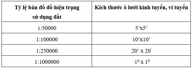
The current land use map is delivered in digital and paper formats along with an accompanying explanatory report.
8. Editing the digital current land use map, in addition to following the provisions of Clauses 1, 2, 3, 4, 5, 6, and 7 of this Article, must also comply with the following requirements:
a) Editing the digital current land use map shall be carried out in accordance with Point e Clause 6 Article 17 of this Circular.
b) Objects on the current land use map must be correctly represented by layer, color, line strength, and accompanying parameters as stipulated in the object classification table in Appendix No. 04 attached to this Circular. Each delineation must have a land type code, and when editing, items deleted for printing must not be erased but transferred to a separate layer for storage. The product must include an accompanying history note.
9. The explanatory report of the current land use map includes the following contents:
a) Legal basis; purpose and requirements for establishing the current land use map;
b) Overview of natural conditions and socio-economic conditions of the administrative unit;
c) Time of construction and completion of the current land use map;
d) Sources of materials used and methods and technology for establishing the current land use map;
đ) Evaluation of the quality of the current land use map regarding completeness, detail, and accuracy of content elements;
e) Existing issues and limitations of the current land use map;
g) Conclusions and recommendations for measures to address limitations and existing issues.
Article 19. Procedures for Regular Land Statistics
1. Preparation work at various levels shall be carried out as follows:
a) The General Department of Land Administration shall perform the following tasks:
- Issuing guidance documents to implement regular land statistics if necessary two months before the implementation date;
- Collecting data on the results of previous year's land statistics, land inventory results, and the most recent land use status map of the whole country; land use plans for the year of statistics;
b) Provincial and district People's Committees shall direct and perform the following tasks:
- Issuing guidance and urging documents to implement regular land statistics if necessary one month before the statistics date;
- Collecting results of previous year's land statistics, results of the most recent land inventory; files of land use plans for the year of statistics;
- Reviewing, compiling parcels of land with changes in land type and user type, management subjects who have completed administrative procedures related to land within the year from cadastral files and other relevant land-related files, and submitting them to the People's Committee of communes before November 15th for annual land statistics (except for communes that have established a unified land database at all levels); in cases where new changes occur after the submission of the summary report, they must be supplemented by December 31st of the year of statistics;
c) Commune People's Committees shall perform the following tasks:
- Collecting, evaluating, and selecting relevant materials and data for land statistics work including results of previous year's land statistics, land inventory results, and the most recent land use status map; files of land use plans for the year of statistics; cadastral files; notifications of cadastral file corrections, summaries of change cases transferred by the Land Registration Office for cases involving land allocation, lease, recovery, and changes in land use during the statistical period;
- Preparing forms for land statistics.
2. Implementation of land statistics at various levels shall be carried out as follows:
a) Commune People's Committees shall perform the following tasks:
- Reviewing actual cases where land has been recovered, allocated, leased, changed in purpose, and registered for land use changes by competent state agencies to determine and correct land demarcation maps for changes in land type, user type, and management subjects within the year of statistics; confirming cases of changes that have completed administrative procedures but not yet implemented in reality, and recording them in the summary of change cases transferred by the Land Registration Office;
- Compiling commune-level land use status statistics data including Forms: 01/TKDD, 02/TKDD, 03/TKDD, 05/TKDD, and 05a/TKDD;
- Analyzing and assessing the current land use status and land change situation in the locality, preparing Forms: 12/TKDD, 13/TKDD, and 14/TKDD;
- Preparing reports on land statistics results;
- Checking, completing, approving, printing, and submitting commune-level land statistics result reports to the district level;
b) District and provincial People's Committees shall direct and perform the following tasks:
- Receiving and checking land statistics data submitted by subordinate levels; directing subordinate levels to correct and complete statistics data and reports (if necessary);
- Compiling district and provincial-level land use status statistics data including Forms: 01/TKDD, 02/TKDD, 03/TKDD, 04/TKDD, 05/TKDD, and 11/TKDD;
- Analyzing statistics data, assessing the current land use status and land change situation in the locality, preparing Forms: 12/TKDD, 13/TKDD, 14/TKDD, and 15/TKDD;
- Preparing reports on district and provincial-level land statistics results;
- Checking, completing, approving, printing, and submitting local land statistics result reports to the immediate superior authority according to this Circular;
c) The General Department of Land Administration shall direct and perform the following tasks:
- Receiving and checking, processing statistics data and reports on land statistics results from the provincial level; directing provinces to correct and complete statistics data and reports (if necessary);
- Compiling land use status statistics data for regions and the whole country including Forms: 01/TKDD, 02/TKDD, 03/TKDD, 04/TKDD, 05/TKDD, and 11/TKDD;
- Analyzing statistics data, assessing the current land use status and land change situation in regions and the whole country, preparing Forms: 12/TKDD, 13/TKDD, 14/TKDD, and 15/TKDD;
- Preparing a Report on land statistics results for the whole country;
- Checking, completing, approving, printing, and submitting the report to the Prime Minister on land statistics results for regions and the whole country;
- Submitting to the Minister for decision to announce land statistics results for the whole country.
Article 20. Procedures for conducting land inventory and preparing current land use maps on a regular basis
1. Preparation work at various levels shall be carried out as follows:
a) The General Department of Land Administration shall perform the following tasks:
- Four months prior to the land inventory date, the project for the land inventory must be completed, along with the preparation of current land use maps to be submitted by the Minister to the Prime Minister for approval; plans for implementation and guiding documents must also be prepared and submitted to the Minister for approval;
- Two months prior to the land inventory date, training sessions for local areas must be completed;
- Collect planning materials, land use plans, results of land statistics from the last five years, results of previous land inventories, and current land use maps from two previous periods;
b) The provincial People's Committee shall organize and direct the completion of the following tasks two months before the land inventory date:
- Develop plans for the land inventory and prepare current land use maps at all administrative levels within the locality;
- Establish a steering committee for the land inventory; develop plans and guiding documents for implementation (if applicable); prepare human resources, assign responsibilities, and coordinate between forces involved in the land inventory;
- Prepare technical equipment and financial resources as prescribed and organize training sessions for communes and districts;
- Collect, evaluate, and select relevant land-related materials for the land inventory including planning files, land use plans; results of land statistics from the last five years, results of previous land inventories, and current land use maps from two previous periods;
- Prepare maps and digital data as required under points b, c, and d of Clause 3, Article 17 of this Circular to serve the land inventory and preparation of current land use maps at the commune level according to approved plans;
In cases where maps and data as stipulated in point d of Clause 3, Article 17 are used, the consolidation of content as prescribed in point a of Clause 4, Article 17 of this Circular must be carried out;
- Review and compile parcels of land that have changed in type, user category, or management entity during the land inventory period based on land administration records and related land procedures (according to Appendix 03.2 of this Circular) and submit to the commune People's Committee before August 1st of the inventory year for the land inventory; if new changes occur after the submission of the summary report, they must be compiled and supplemented no later than December 31st of the inventory year;
- Review the administrative boundaries of the province to identify cases of disputed or inconsistent administrative boundaries between record and actual conditions, and work with the People's Committees of related administrative units to unify the scope and responsibility of each party's land inventory as prescribed in Clause 3, Article 11 of this Circular and instruct the People's Committees of counties and communes to implement;
- Disseminate and ensure understanding of tasks among sectors and levels, and publicize to the people about policies and plans for the land inventory;
c) The county People's Committee shall organize and direct the completion of the following tasks one month before the land inventory date:
- Develop plans and implementation schemes for the land inventory and preparation of current land use maps within the county;
- Prepare human resources, technical equipment, and financial resources as prescribed to serve the land inventory and preparation of current land use maps; assign responsibilities and coordinate between forces involved;
- Collect, evaluate, and select relevant land-related materials for the land inventory including planning files, land use plans; results of land statistics from the last five years, results of previous land inventories, and current land use maps from two previous periods;
- Coordinate with the Branch of the Land Registration Office to review and compile cases of land changes that have completed administrative procedures during the land inventory period within the jurisdiction of the county People's Committee (according to Appendix 03.2 of this Circular) and transfer them to the commune People's Committee before August 1st of the inventory year for the land inventory; simultaneously continue compiling cases of land changes that have completed administrative procedures until December 31st of the inventory year to supplement and send to the commune People's Committee for the land inventory;
- Disseminate and ensure understanding of tasks among sectors and levels, and publicize to the people about policies and plans for the land inventory;
- Review the administrative boundaries of the county to identify cases of disputed boundaries or inconsistencies between boundary records and actual conditions, and work with the People's Committees of related administrative units to unify the scope and responsibility of each party's land inventory as prescribed in Clause 3, Article 11 of this Circular and instruct the commune People's Committee to implement;
d) The commune People's Committee shall organize and complete the following tasks before the land inventory date:
- Develop plans and implementation schemes for the land inventory within the commune;
- Prepare human resources and technical equipment to serve the land inventory; assign responsibilities to participating forces;
- Disseminate and ensure understanding of tasks among cadres and publicize to the people about policies and plans for the land inventory;
- Collect existing land-related materials and data for the land inventory including various types of maps and data for surveying and delineating current status; land administration files; notifications of land change corrections and extracts from maps and diagrams attached; inspection, supervision, and violation handling files in land use; results of land statistics from the last five years, results of previous land inventories, and current land use maps from two previous periods; summary tables of changes during the inventory period transferred by the Land Registration Office and other related land files;
- Review, compare, assess the usability, and select collected materials, data, and maps for use in the land inventory;
- Review the administrative boundary limits on maps used for investigation and inventory to align with the latest approved border maps and administrative boundary maps. In cases where there is a dispute over the administrative boundary of communes or inconsistencies between the records and the actual site, the People's Committees of the relevant commune-level administrative units shall work together to unify the scope and responsibilities for land inventory according to Clause 3, Article 11 of this Circular;
- Print materials serving the land inventory (excluding maps for investigation purposes);
- Review and collect information to identify areas with changes on-site during the inventory period that require map corrections, additional investigations, and delineation of non-inventory areas;
2. Organize the implementation of land inventory and create current land use status maps at various levels as follows:
a) The People's Committee at the commune level shall organize the following tasks:
- Review, delineate, and make internal corrections to maps and data used for investigation and inventory for cases involving land administrative procedures that have been completed, and compile and aggregate parcels of land into delineated areas according to Points b and c, Clause 4, Article 17 of this Circular; print maps for non-inventory field delineation;
- Conduct field surveys and delineations to supplement and correct boundaries of delineated areas regarding land types (primary purpose, secondary purpose if applicable), land users, land managers; determine cases with decisions on land allocation, land leasing, permission to change land use purposes but not yet implemented, and cases of improper land use; areas requiring comprehensive statistics;
- Transfer, process, and finalize delineated areas on the digital land inventory map, updating land type and user information according to detailed, comprehensive, and specialized inventory criteria (if applicable); compile maps and calculate the area of delineated areas;
- Create a list of delineated areas from the results of field surveys; - Compile current land use data at the commune level including Tables: 01/TKDD, 02/TKDD, 02a/TKDD, 03/TKDD, 05/TKDD, 05a/TKDD, 06/TKDD, 06a/TKDD, 07/TKDD, 08/TKDD, 09/TKDD, and 10/TKDD;
- Analyze and assess the current land use status, land changes, and land management situation in the locality, creating Tables: 12/TKDD, 13/TKDD, and 14/TKDD;
- Create a current land use status map at the commune level and prepare an accompanying explanatory report;
- Prepare a report on the land inventory results;
- Inspect and approve the land inventory results, creating a current land use status map at the commune level;
- Finalize, review, copy, and submit the land inventory report and current land use status map to the district level;
b) The People's Committee at the district and provincial levels shall organize, direct, and implement the land inventory and create current land use status maps at each level, including the following tasks:
- Supervise, urge, guide, and direct the implementation at all levels;
- Coordinate with the Ministry of National Defense and the Ministry of Public Security in the land inventory for defense and security purposes, receiving and checking the unified results of the defense and security land inventory submitted by the People's Committee at the commune level for consolidation;
- Receive and check the land inventory results and current land use status maps submitted by lower levels; direct corrections and improvements to the data and reports on the land inventory results and current land use status maps (if necessary);
- Compile current land use data at the district and provincial levels including Tables: 01/TKDD, 02/TKDD, 02a/TKDD, 03/TKDD, 04/TKDD, 05/TKDD, 06/TKDD, 07/TKDD, 08/TKDD, 09/TKDD, 10/TKDD, and 11/TKDD;
- Analyze and assess the current land use status, land changes, and land management situation in the locality, creating Tables: 12/TKDD, 13/TKDD, 14/TKDD, and 15/TKDD;
- Create current land use status maps at the district and provincial levels and prepare an accompanying explanatory report;
- Prepare a report on the land inventory results and create current land use status maps at the district and provincial levels;
- Inspect and approve the land inventory results and current land use status maps at the district and provincial levels;
- Finalize, review, copy, and submit the land inventory result report to the higher authority as stipulated in this Circular;
c) The General Department of Land Administration shall direct and perform the following tasks:
- Supervise, monitor, urge, guide, and direct the implementation in localities;
- Receive and check the land inventory results and current land use status maps submitted by the province; direct the province to correct and improve the data and reports on the land inventory results and current land use status maps of the locality (if necessary);
- Compile current land use data for regions and nationwide, including Tables: 01/TKDD, 02/TKDD, 02a/TKDD, 03/TKDD, 04/TKDD, 05/TKDD, 06/TKDD, 07/TKDD, 08/TKDD, 09/TKDD, 10/TKDD, and 11/TKDD;
- Analyze and assess the current land use status, land changes, and land management situation in the locality, creating Tables: 12/TKDD, 13/TKDD, 14/TKDD, and 15/TKDD;
- Create current land use status maps for regions and nationwide and prepare an accompanying explanatory report on the current land use status;
- Prepare a national land inventory result report for approval by the Minister; report
Article 21. Periodic Statistics and Inventory of National Defense and Security Land.
1. The periodic statistics and inventory of national defense land and security land shall be organized by the Ministry of National Defense and the Ministry of Public Security, in coordination with the People's Committee at the provincial level.
2. All levels of People's Committees shall cooperate with the Ministry of National Defense and the Ministry of Public Security to review locations and areas of land used for national defense and security purposes; unify statistical and inventory data on national defense and security land in their localities with the Ministry of National Defense and the Ministry of Public Security.
3. The criteria for periodic statistics and inventory of national defense and security land include various types of land as stipulated in Article 61 of the Land Law. The form for the statistics and inventory of national defense and security land shall be carried out according to Model Form 16/TKDD attached as Appendix No. 02 of this Circular.
4. The submission of results of periodic statistics and inventory of national defense and security land shall be regulated as follows:
a) The Ministry of National Defense and the Ministry of Public Security shall be responsible for sending the results of periodic statistics and inventory of national defense and security land in each locality to the People's Committee at the provincial level for consolidation; and send the results of statistics and inventory of national defense and security land nationwide to the Ministry of Natural Resources and Environment for consolidation and reporting. Prime Minister;
b) The results of periodic statistics of national defense and security land include:
- Table of current land use data for national defense and security land;
-Report on the results of periodic statistics of national defense and security land;
c) The results of periodic inventory of national defense and security land include:
- Table of current land use data for national defense and security land;
- Diagrams delineating land use for national defense and security purposes in each province and centrally-administered city;
- Report on the results of inventory of national defense and security land;
d) The submission of reports on the results of statistics and inventory of national defense and security land to the People's Committee at the provincial level shall be as follows:
- The file containing the results of land statistics and inventory includes the relevant documents on the results of statistics and inventory of national defense and security land in the locality as specified in points b and c of this clause;
- The deadline for submitting the results of statistics and inventory of national defense and security land to the People's Committee at the provincial level is before January 16 of the following year after the year in which the land statistics and inventory were conducted;
đ) The submission of the results of statistics and inventory of national defense and security land to the Ministry of Natural Resources and Environment shall be as follows: - The file containing the results of land statistics and inventory includes tables of current land use data for national defense and security land in each province and nationwide; report on the results of statistics and inventory of national defense and security land nationwide as specified in points b and c of this clause; - The deadline for submitting the results of statistics and inventory: Before February 16 of the following year after the year in which the land statistics were conducted (for the results of land statistics); before April 16 of the following year after the year in which the land inventory was conducted (for the results of land inventory).
Section 4
INSPECTION, HANDOVER, MANAGEMENT OF RESULTS OF PERIODIC LAND STATISTICS AND INVENTORY
Article 22. Inspection of Results of Periodic Land Statistics and Inventory
1. The contents of inspection include:
a) The completeness of documents and data and the legality of the files containing the results of land statistics and inventory;
b) The completeness and accuracy of the delineation of land plots and determination of land types and land users, land managers on the cadastral map at the commune level;
c) The completeness and accuracy of the compilation of land plots in the list of land plots for statistics and inventory compared to the cadastral map and the consolidated table of land changes reviewed and confirmed by the People's Committee at the commune level;
d) The accuracy in compiling data in the land statistics and inventory tables;
đ) The consistency of data between land statistics and inventory tables and the cadastral map at the commune level; between statistics and inventory data tables at different levels; between data tables and reports on the results of land statistics and inventory;
e) The quality of the report on the results of land statistics and inventory and the creation of the current land use map regarding the completeness and consistency of content; the quality of analysis reflecting the current land use status; the quality of content proposing management and utilization solutions;
g) The quality of the current land use map regarding format, completeness of content and place names; consistency between color and symbols of land types; accuracy of delineated land plots on the map; deviation in area of land types between the current land use map and inventory data; consistency of inventory data with explanatory tables and charts of the current land use map at each level (conducted for land inventory);
2. Responsibilities for inspecting the results of land statistics and inventory, creating the current land use map are regulated as follows:
a) Units and individuals directly implementing tasks related to land statistics and inventory, and creation of the current land use map shall be responsible for self-inspection during the implementation process and after completing each product;
b) The People's Committee at the commune level shall inspect and take responsibility for the commune-level implementation results before approval;
c) The Department of Natural Resources and Environment shall inspect the commune-level implementation results before acceptance; inspect and take responsibility for the district-level implementation results before submitting to the People's Committee at the district level for approval;
d) The Land Registration Office shall inspect the district-level implementation results before acceptance;
đ) The Department of Natural Resources and Environment at the provincial level shall inspect and take responsibility for the provincial-level implementation results before submitting to the People's Committee at the provincial level for approval;
e) The State Land Management Agency shall inspect the provincial-level implementation results and those of the Ministry of National Defense and the Ministry of Public Security before acceptance; inspect and take responsibility for the nationwide implementation results before submitting to the Minister of Natural Resources and Environment;
g) In cases where the People's Committees at all levels hire consulting units to perform work related to land statistics and inventory, the competent natural resources and environment agencies shall be responsible for inspecting and accepting products to settle contracts in accordance with the law and this Circular.
3. The inspection of statistical results and land inventory as stipulated in Clauses 1 and 2 of this Article must be documented in writing in accordance with Circular No. 49/2016/TT-BTNMT dated December 28, 2016, issued by the Ministry of Natural Resources and Environment on supervision, inspection, verification, and acceptance of works and products in the field of land management.
Article 23. Documents to submit periodic land statistics and inventory results
1. The documents to submit land statistics results are as follows:
a) The documents submitted by commune level include:
- Land inventory map of the commune that has been updated with changes (one set in digital format) and a summary of land change cases in the year reviewed and confirmed by the People's Committee of the commune (one set in paper form);
- Statistical data tables on land (one set in paper form and one set in digital format);
- Report on land statistics results (one set in paper form).
b) The documents submitted by district level include:
- Land inventory map of the commune that has been updated with changes (one set in digital format);
- Statistical data tables on land at commune level (one set in digital format);
- Statistical data tables on land at district level (one set in paper form and one set in digital format); - Report on land statistics results at district level (one set in paper form and one set in digital format).
c) The documents submitted by provincial level include:
- Statistical data tables on land at commune and district levels (one set in digital format);
- Statistical data tables on land at provincial level (one set in paper form and one set in digital format);
- Report on land statistics results at provincial level (one set in paper form and one set in digital format);
d) The documents submitted by regions and nationwide to the Prime Minister include:
- Statistical data tables on land (in paper form);
- Report on land statistics results (in paper form).
2. The documents to submit land inventory results and create current land use maps are as follows:
a) The documents submitted by commune level include:
- Land inventory map of the commune in file format for area creation and connection of data from the map along with the List of land parcels inventoried and statistically analyzed (one set in digital format);
- Summary table of changes during the inventory period sent by the Land Registration Office and reviewed and confirmed by the People's Committee of the commune (one set in paper form);
- Inventory data tables on land (one set in paper form and one set in digital format if available);
- Current land use map and Explanation report of the current land use map (one set in paper form and one set in digital format in *.DGN format; file format for area creation);
- Report on land inventory results (one set in paper form);
b) The documents submitted by district level include:
- Land inventory map and the List of land parcels inventoried and statistically analyzed (one set in digital format);
- Inventory data tables on land at commune level (one set in paper form and one set in digital format);
- Current land use map at commune level (one set in digital format);
- Inventory data tables on land at district level (one set in paper form and one set in digital format);
- Current land use map at district level and Explanation report of the current land use map (one set in paper form and one set in digital format);
- Report on land inventory results at district level (one set in paper form and one set in digital format);
- Explanation report on current land use (one set in paper form and one set in digital format);
c) The documents submitted by provincial level include:
- Land inventory map, current land use map at commune level and the List of land parcels inventoried and statistically analyzed (one set in digital format);
- Inventory data tables on land and current land use map at district level (one set in digital format);
- Inventory data tables on land at provincial level (one set in paper form and one set in digital format);
- Current land use map at provincial level and Explanation report of the current land use map (one set in paper form and one set in digital format);
- Report on land inventory results at provincial level (one set in paper form and one set in digital format);
- Explanation report on current land use (one set in paper form and one set in digital format);
d) The documents submitted by regions and nationwide to the Prime Minister include:
- Nationwide and regional inventory data tables on land divided by province (one set in paper form);
- Report on land inventory results nationwide (one set in paper form);
- Nationwide current land use map (one set in paper form).
Article 24. Storage, management, and provision of land statistics and inventory data
1. The results of land statistics and inventory at commune, district, provincial, and national levels (in paper and digital form) as stipulated in Article 23 of this Circular shall be managed and stored permanently; maps used for inventory surveys that have been updated and adjusted to reflect changes (in paper form) shall be managed until the inventory results are announced.
2. Tables of statistical data, reports on land statistics and inventory results, and current land use status maps at the commune level shall be stored at the Commune People's Committee and the Environmental Resources Office; digital commune-level land inventory maps shall be stored at the Commune People's Committee, environmental resources agencies at the district and provincial levels, and the Ministry of Natural Resources and Environment; maps used for inventory surveys that have been updated and adjusted to reflect changes (in paper form) shall be managed at the Commune People's Committee.
3. Land statistics and inventory documents at the district level shall be stored at the Environmental Resources Office and the Department of Natural Resources and Environment.
4. Land statistics and inventory documents at the provincial level shall be stored at the Department of Natural Resources and Environment and the Ministry of Natural Resources and Environment.
5. Land statistics and inventory documents at the regional and national levels shall be stored at the Ministry of Natural Resources and Environment.
6. Management and provision of land statistics and inventory data and current land use status maps shall be carried out in accordance with regulations on the management and provision of cadastral file data of the Ministry of Natural Resources and Environment.
Chapter III
SPECIAL LAND INVENTORY
Article 25. Special Land Inventory
1. A special land inventory is a detailed inventory of one or more land types, land user categories, and land management entities specified in Articles 8, 9, and 10 of this Circular, and other related contents according to the requirements of state land management during each period.
2. The content and scope of implementation of special land inventory shall be carried out in accordance with the decision of the Prime Minister or the Minister of Natural Resources and Environment.
3. Based on the decision of the Prime Minister or the Minister of Natural Resources and Environment regarding the special land inventory, the General Department of Land Administration shall be responsible for developing and submitting to the Minister of Natural Resources and Environment for issuance of guiding documents on indicators, forms, methods, implementation plans, and submission files for the results of the special land inventory to organize and implement according to requirements.
Chapter IV
IMPLEMENTATION
Article 26. Effective date
1. This Circular shall take effect from March 1, 2019.
2. This Circular replaces Circular No. 28/2014/TT-BTNMT dated June 2, 2014, of the Ministry of Natural Resources and Environment on land statistics, inventory, and current land use map preparation.
3. Article 21 of Circular No. 02/2015/TT-BTNMT dated January 27, 2015, of the Ministry of Natural Resources and Environment detailing certain provisions of Decree No. 43/2014/NĐ-CP and Decree No. 44/2014/NĐ-CP dated May 15, 2014, of the Government is hereby repealed.
4. In cases where the legal normative documents cited in this Circular are amended or supplemented, they shall be implemented in accordance with the provisions of the amended or supplemented documents.
Article 27. Implementation Organization
1. Ministries, ministerial-level agencies, agencies under the Government; Provincial People's Committees shall be responsible for directing the implementation of this Circular.
2. Provincial People's Committees shall be responsible before the Prime Minister for the implementation and reporting of land statistics, inventory results, and current land use map preparation in their locality, ensuring quality, implementation time, and reporting deadlines sent to the Ministry of Natural Resources and Environment for consolidation and reporting to the Prime Minister in accordance with this Circular.
3. The General Department of Land Administration shall be responsible for inspecting the implementation of this Circular.
4. Departments of Natural Resources and Environment shall be responsible for assisting provincial People's Committees and municipal People's Committees directly under the Central Government in implementing this Circular in their localities. During the organization and implementation process, if there are difficulties or obstacles, agencies, organizations, and individuals shall report to the Ministry of Natural Resources and Environment for consideration and resolution.
During the organization and implementation process, if there are difficulties or obstacles, agencies, organizations, and individuals shall report to the Ministry of Natural Resources and Environment for consideration and resolution./.
DEPUTY MINISTER
관계도
문서를 클릭하면 열립니다. 빨간 테두리=효력을 변경하는 관계.