
Circular No. 01/2025/TT-BKHĐT stipulates the national statistical indicators for the sea and islands as well as the national strong sea evaluation indicators, applicable to agencies, organizations, and individuals providing statistical information related to the sea and islands. This Circular takes effect from March 10, 2025.
Scope of application
Agencies, organizations, and individuals providing statistical information on the sea and islands and evaluating the national strong sea.
Key points
- Agencies, organizations, and individuals providing statistical information on the sea and islands must comply with the national statistical indicators for the sea and islands and the national strong sea evaluation indicators.
- The national statistical indicators for the sea and islands consist of 53 indicators, including 28 indicators for evaluating the national strong sea.
- Statistical information is collected and compiled by the General Statistics Office under the Ministry of Planning and Investment.
- This Circular takes effect from March 10, 2025.
🌐 Social impact of this document
- Positive impact: Providing accurate statistical data, helping to assess the sustainable development of the marine economy.
- Negative impact: It may impose a burden in terms of time and cost on agencies and organizations required to collect information.
❓ Frequently asked questions
What does the national statistical indicators for the sea and islands include?
The national statistical indicators for the sea and islands include 53 indicators, among which there are 28 indicators for evaluating the national strong sea (Article 3).
Which agencies and organizations are responsible for collecting statistical information?
The General Statistics Office under the Ministry of Planning and Investment is the main agency coordinating with relevant units to collect information (Article 4).
When does this Circular take effect?
This Circular takes effect from March 10, 2025 (Article 5).
What contents do the national statistical indicators for the sea and islands cover?
The contents of the statistical indicators are specified in Appendix II attached to this Circular (Article 3).
How can agencies and organizations submit their comments on difficulties?
Agencies and organizations can submit their comments to the Ministry of Planning and Investment (General Statistics Office) for guidance or further study and amendment (Article 5).
Full text
|
MINISTRY OF PLANNING AND INVESTMENT |
SOCIALIST REPUBLIC OF VIET NAM |
|
Number: 01/2025/TT-BKHĐT |
Hanoi, January 2, 2025 |
CIRCULAR
Regulations on the national statistical indicators for the sea and islands and the national strong sea evaluation indicators
Pursuant toLaw on Statistics dated November 23, 2015;Law amending and supplementing certain articles and the National Statistical Indicator Catalogue of the Law on Statistics dated November 12, 2021;
Pursuant toLaw on Marine Resources, Environment, and Islands dated June 25, 2015;
Pursuant toLaw amending and supplementing certain articles of 37 related laws concerning planning dated November 20, 2018;
Pursuant to Decree No.Decree No. 40/2016/NĐ-CP dated May 15, 2016 of the Government detailing and guiding implementation of certain provisions ofthe Law on Marine Resources, Environment, and Islands;
Pursuant to Decree No.Decree No. 94/2016/NĐ-CP dated July 1, 2016 of the Government detailing and guiding implementation of certain provisions ofthe Law on Statistics;
Pursuant to Decree No.Decree No. 94/2022/NĐ-CP dated November 7, 2022 of the Government stipulating the content of national statistical indicators within the national statistical indicator system and the process of compiling gross domestic product indicators and provincial gross domestic product indicators;
Pursuant to Decree No.Decree No. 62/2024/NĐ-CP dated June 7, 2024 of the Government amending and supplementing certain articles and appendices of Decree No.Decree No. 94/2016/NĐ-CP dated July 1, 2016 of the Government detailing and guiding implementation of certain provisions ofthe Law on Statistics and Decree No.94/2022/NĐ-CP dated November 7, 2022 of the Government stipulating the content of national statistical indicators within the national statistical indicator system and the process of compiling gross domestic product indicators and provincial gross domestic product indicators;
Pursuant to Decree No.Decree No. 89/2022/NĐ-CP dated October 28, 2022 of the Government stipulating the functions, tasks, powers, and organizational structure of the Ministry of Planning and Investment;
At the proposal of the General Statistics Office Director;
The Minister of Planning and Investment issues this Circular to regulate the national statistical indicators for the sea and islands and the national strong sea evaluation indicators.
Article 1. Scope of Regulation
This Circular regulates the national statistical indicators for the sea and islands and the national strong sea evaluation indicators of Vietnam.
The national statistical indicators for the sea and islands and the national strong sea evaluation indicators are a set of statistical indicators related to many industries, many fields, regional economic, social, and environmental connections related to the sea, aiming to provide data and assess the sustainable development of Vietnam's marine economy.
Article 2. Applicability
This Circular applies to agencies, organizations, and individuals providing statistical information, producing statistical information, and using statistical information on the sea and islands and the national strong sea evaluation.
Article 3. National statistical indicators for the sea and islands and national strong sea evaluation indicators
The national statistical indicators for the sea and islands and the national strong sea evaluation indicators include:
1. The list of national statistical indicators for the sea and islands includes 53 statistical indicators specified in Appendix I attached to this Circular.
2. The list of national strong sea evaluation indicators includes 28 statistical indicators marked with a checkmark in the column "national strong sea evaluation indicators" specified in Appendix I attached to this Circular.
3. The content of the national statistical indicators for the sea and islands and the national strong sea evaluation indicators is specified in Appendix II attached to this Circular.
Article 4. Organization of Implementation
1. The Ministry of Planning and Investment (General Statistics Office) shall take the lead and coordinate with relevant units:
a) Collect statistical information for the national statistical indicators for the sea and islands and the national strong sea evaluation indicators assigned, ensuring the provision of complete, accurate, timely statistical data and meeting international comparison requirements;
b) Develop and improve the methods of collecting information for the national statistical indicators for the sea and islands and the national strong sea evaluation indicators;
c) Apply information technology in the process of storing and exploiting statistical data on the sea and islands and the national strong sea evaluation;
d) Aggregate statistical information within the national statistical indicators for the sea and islands and the national strong sea evaluation indicators; monitor, guide, and report on the implementation of this Circular.
2. Ministries, ministerial-level agencies, government-affiliated agencies, provincial People's Committees, centrally governed cities, and related agencies shall implement the integration, collection, and aggregation of assigned indicators based on the national statistical indicators for the sea and islands and the national strong sea evaluation indicators, and provide them to the Ministry of Planning and Investment (General Statistics Office) for consolidation and compilation.
Article 5. Effective Date
1. This Circular takes effect from March 10, 2025.
2. During implementation, if there are difficulties, agencies, organizations, and individuals should send their opinions to the Ministry of Planning and Investment (General Statistics Office) for timely guidance, research, and amendment.
|
Place of Receipt: |
THE MINISTER |
ANNEX I
NATIONAL STATISTICAL INDICATORS FOR THE SEA AND ISLANDS AND NATIONAL STRONG SEA EVALUATION INDICATORS
(Annexed to Circular No. 01/2025/TT-BKHĐT dated January 2, 2025 issued by the Minister of Planning and Investment)
010101 National Integrated Marine and Island Governance Index of Coastal Provinces and Cities under Central Administration Bx020102 Human Development Index (HDI) of Coastal Provinces and Cities under Central Administration Ax030201 Number of Households Engaged in Marine Fisheries Harvesting and Cultivation A 040202 Number of Fishery Service Infrastructure Facilities A 050203 Volume of Marine Aquaculture Cages and Rafts A 0602040811 Number of Motorized Fishing Boats A 070205 Number of Marine Economic Centers B 080206 Number of Ships A 0902071207 Existing and Newly Added Loading Capacity of Seaports A 100208 Number of Coastal Tourism Accommodation Facilities A 110209 Number of Rooms in Coastal Tourism Accommodation Facilities A 120210 Number of International Tourists Arriving in Vietnam via Sea Route Ax130211 Number of Passengers Transported and Transferred via Sea Route Ax140212 Volume of Goods Transported and Transferred via Sea Route Ax150213 Volume of Goods Passing Through Seaports Ax160214 Area of Marine Aquaculture Water Surface A 170215 Area of Marine Aquaculture Harvest A 180216 Area of Coral and Seagrass Distribution Zone A 190217 Area of Marine Aquaculture Certified with Good Aquaculture Practices (VietGAP) and Equivalent A 200218 Marine Fisheries Catch Volume Ax210219 Marine Aquaculture Production Volume Ax220220 Oil and Gas Extraction Volume Ax230221 Export Value of Marine Aquatic Products Ax240222 Revenue from Sea Transportation, Port Warehousing, and Supporting Services Ax250223 Revenue from Offshore Wind and Tidal Power Ax260224 Installed Capacity and Production from Wind and Tidal Energy A 270225 Proportion of Wind and Tidal Energy in Primary Energy Supply Ax280226 Proportion of Electricity Generated from Wind and Tidal Energy in Total Electricity Production Ax290227 Proportion of Blue Economy Value Added in Gross Domestic Product Bx300228 Contribution Rate of Provincial Gross Product of Coastal Provinces and Cities under Central Administration to National Gross Domestic Product Ax310301 Average Monthly Income of Coastal Provinces and Cities under Central Administration Ax320302 Number of Workers in Marine Economic Sectors B 330303 Average Income of Workers in Marine Economic Sectors B 340304 Ratio of Island District Hospitals Capable of Implementing Surgical Techniques Equivalent to Class II Hospitals Bx350305 Ratio of Island Communes Meeting National Health Standards Bx360306 Ratio of Coastal Shipping Vessels Fully Complying with Health Regulations Ax370307 Number of Seafarers with Professional Certificates Working on Coastal Shipping Vessels A 380308 Number of Graduates from Vocational Education Institutions in Marine Economy Related Fields A 390401 Number of Marine Disposal Permits Issued A 400402 Number of Oil Spills and Chemical Leaks, Affected Areas A 410403 Length of Coastline and Area Under Integrated Management A 420404 Number of Endangered, Precious, and Rare Aquatic Species Successfully Reproduced and Cultivated Ax430405 Number of Endangered, Precious, and Rare Aquatic Species Monitored and Assessed for Environmental Impact Ax440406 Number, Area, and Proportion of Marine Protected Areas Relative to National Marine Natural Area Ax450407 Number, Area, and Proportion of Marine Fisheries Resource Protection Zones Ax460408 Number, Area, and Proportion of Temporary Marine No-Take Zones Ax470409 Number, Area, and Proportion of Artificial Habitats for Marine Aquatic Species Ax480410 Area of Mangrove Forests Along the Coast A 490411 Area of Marine Zones Assigned, Leased, and Currently Exploited A 500412 Proportion of Marine Areas Surveyed at a Scale of 1:500,000 Map Bx510413 Proportion of Restored Marine Ecosystems Bx520414 Proportion of Hazardous Waste and Household Solid Waste Collected and Treated to Environmental Standards in Coastal Provinces and Cities under Central Administration Ax530415 Proportion of Coastal Economic Zones, Industrial Parks, and Urban Areas Planned and Constructed in a Sustainable Manner Ax
Serial Number
Code Number
National Statistical Indicator Code
Group, name of indicator
Implementation schedule
National Strong Marine Economy Evaluation Indicators
01. Comprehensive Indicators
02. Marine Economy
03. Society
04. Environment
Note:
- Route A: Applies to indicators that can be implemented immediately upon the Circular's effectiveness due to existing data or information sources for calculation and compilation.
- Route B: Applies to indicators that cannot be implemented immediately due to lack of data or ongoing research, expected to be implementable from 2026.
ANNEX II
CONTENT OF NATIONAL STATISTICAL INDICATORS ON THE SEA AND ISLANDS AND NATIONAL STRONG MARINE ECONOMY EVALUATION INDICATORS
(Annexed to Circular No. 01/2025/TT-BKHĐT dated January 2, 2025 issued by the Minister of Planning and Investment)
Group 01. Comprehensive Indicators
0101. National Integrated Marine and Island Governance Index of Coastal Provinces and Cities under Central Administration
1. Concept, Calculation Method
The National Integrated Marine and Island Governance Index of Coastal Provinces and Cities under Central Administration is a comprehensive measure reflecting the current status of the sea and islands across six main areas: (1) Implementation of provincial and city-level programs and action plans; (2) Coastal business environment management; (3) Coastal water quality management; (4) Coastal mineral resources, energy, and transportation management; (5) Coastal land management; and (6) Coastal biological resource management.
Calculation Method: The National Integrated Marine and Island Governance Index of Coastal Provinces and Cities under Central Administration is calculated using the arithmetic mean method of component indices.
2. Publication Period: Yearly.
3. Data Sources
- National Statistical Reporting System;
- Ministry and Sector Statistical Reporting System;
- Statistical Surveys;
- Administrative Data.
4. Agency responsible for collecting and compiling: Ministry of Planning and Investment (General Statistics Office).
0102. Human Development Index (HDI) of coastal provinces and centrally governed cities.
1. Concept, Calculation Method
1.1. Method for calculating the composite HDI index.
The Human Development Index (HDI) is a composite measure reflecting human development across three dimensions: health (represented by life expectancy at birth), knowledge (represented by education), and income (represented by gross national income per capita).
The Human Development Index is calculated using the formula:

Where:
HDI
: Human Development Index;
Ihealth
: Health Index, calculated through the average life expectancy at birth indicator; also known as average life expectancy or average life prospects at birth;
I教育
: Education Index, calculated through two indicators: the average years of schooling for those aged 25 and above and the expected years of schooling for children of school age;
Iincome
: Income Index, calculated through the gross national income (GNI) per capita adjusted for purchasing power parity (PPP).
HDI ranges from 0 to 1 (0 ≤ HDI ≤ 1). HDI reaches its maximum value of 1, indicating ideal levels of human development; HDI at its minimum value of 0 indicates a society without humanistic development. Based on the HDI value, UNDP has ranked countries, regions, or areas within a country into four groups:
- Group 1: Very high level with HDI ≥ 0.800;
- Group 2: High level with 0.700 ≤ HDI < 0.800;
- Group 3: Medium level with 0.550 ≤ HDI < 0.700;
- Group 4: Low level with HDI < 0.550.
1.2. Method for calculating component indices
a) Health Index

Where:
Ihealth: Health Index;
|
|
: Actual average life expectancy at birth achieved; |
|
|
: Minimum average life expectancy at birth fixed at 20 years; |
|
|
: Maximum average life expectancy at birth fixed at 85 years. |


b) Education Index
The Education Index is calculated through two indicators:
- Average years of schooling for those aged 25 and above;
- Expected years of schooling for children of school age.
Corresponding to these two indicators, there are two indices that need to be calculated. To determine the value of the education index constituting the HDI, three steps must be taken:
Step 1: Calculate the average years of schooling index for those aged 25 and above (hereinafter referred to as the average years of schooling) according to the formula:

Where:
Ithe actual shortest distance of each position receiving the allocation.: Average years of schooling index;
|
|
: Actual average years of schooling achieved; |
|
|
: Minimum average years of schooling fixed at 0; |
|
|
: Maximum average years of schooling fixed at 15 years. |


Step 2: Calculate the expected years of schooling index for children of school age (hereinafter referred to as the expected years of schooling) according to the formula:

Where:
Iexpected: Expected years of schooling index;
|
|
: Actual expected years of schooling achieved; |
|
|
: Minimum expected years of schooling fixed at 0; |
|
|
: Maximum expected years of schooling fixed at 18 years. |


Step 3: Calculate the education index:
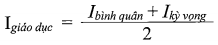
Where:
Ieducation: Education index;
Ithe actual shortest distance of each position receiving the allocation.: Average years of schooling index;
Iexpected: Expected years of schooling index.
c) Income Index
The Income Index is determined by the natural logarithm of the gross national income (GNI) per capita adjusted for purchasing power parity (PPP) (usually converted to US dollars (USD - PPP)).

Where:
Iincome: Income Index;ln: Natural logarithm;
|
|
: Actual GNI per capita achieved, in USD - PPP; |
|
|
: Minimum GNI per capita fixed at 100 USD - PPP; |
|
|
: Maximum GNI per capita fixed at 75,000 USD - PPP. |


2. Publication Period: Yearly.
3. Data Sources
- National Population and Housing Census;
- National Economic Census;
- Mid-term Population and Housing Survey;
- Population Dynamics and Family Planning Survey;
- Results of national statistical surveys under the National Statistical Survey Program;
- Administrative reports;
- International Comparison Program (ICP).
4. Agency responsible for collecting and compiling
- Lead agency: Ministry of Planning and Investment (General Statistics Office);
- Coordination: General Statistics Office; Departments and sectors of coastal provinces and centrally governed cities.
Chapter 02. Marine Economy
0201. Number of Households Engaged in Marine Fisheries and Aquaculture
1. Concept, Calculation Method
The number of households engaged in marine fisheries and aquaculture is the total number of households where all or most of the household's labor force participates in marine fisheries and aquaculture activities. Members of the household organize production independently and make all decisions regarding production.
Marine fishing is the activity of catching or providing support services for marine fishing.
The marine area for aquaculture is a sea area including water bodies and seabed; it has defined boundaries starting from the lowest average sea level line extending seaward for aquaculture purposes (Clause 17 Article 3 of the Fisheries Law).
2. Main Classification: Coastal provinces and centrally governed cities.
3. Publication Period: Every five years.
4. Data Sources
- Rural and Agricultural Census;
- Mid-term Rural and Agricultural Survey.
5. Agency responsible for collecting and compiling: Ministry of Planning and Investment (General Statistics Office).
0202. Number of Fishery Support Service Facilities
1. Concept, Calculation Method
Fishery support service facilities are establishments producing and trading in industries serving fishing, processing, preserving, and ensuring the circulation and distribution of seafood (such as fuel supply, ice, fishing gear supplies for fishing vessels, fish ports, fish landing sites, seafood storage warehouses, new construction and modification of fishing vessels, communication...); anchorage areas for fishing vessels to avoid storms.
Calculation method: Aggregate the number of fishery support service facilities by type of service at the reporting location.
2. Main Classification
- Type of service;
- Scale and capacity;
- Coastal provinces and centrally governed cities.
3. Publication Period: Every five years.
4. Data Sources
- Rural and Agricultural Census;
- Mid-term Rural and Agricultural Survey.
5. Agency responsible for collecting and compiling: Ministry of Planning and Investment (General Statistics Office).
0203. Volume of Marine Aquaculture Cages and Rafts
1. Concept, Calculation Method
The volume of marine aquaculture cages and rafts is the part of the cage or raft volume enclosed for marine aquaculture.
Calculation formula:
Volume of cages and rafts = Length x Width x Depth submerged
2. Main Classification
- Major marine seafood types;
- Central province/city directly under the central government with sea coast.
3. Publication period: Year.
4. Data Sources
- Fisheries survey;
- Statistical reporting system for industry statistics.
5. Agency responsible for collecting and compiling: Ministry of Planning and Investment (General Statistics Office).
0204. Number of fishing vessels with engines
1. Concept, Calculation Method
The number of fishing vessels with engines includes all vessels (including boats) equipped with dedicated engines for marine fishing, including those undergoing major repairs, minor repairs. The number includes registered and inspected vessels as well as unregistered and uninspected ones.
The number of fishing vessels with engines does not include motorized vessels for marine fishery support services.
The number of fishing vessels with engines is counted at the time of observation.
2. Main Classification
- Main fishing occupation;
- Length of vessel;
- Central province/city directly under the central government;
- Economic and social region.
3. Publication period: Year.
4. Data Sources
- Rural and Agricultural Census;
- Mid-term rural and agricultural survey;
- Fisheries survey.
5. Agency responsible for collecting and compiling: Ministry of Planning and Investment (General Statistics Office).
0205. Number of marine economic centers
1. Concept, Calculation Method
The number of marine economic centers is the total number of marine economic centers meeting the current standards.
2. Publication Period: Yearly.
3. Data source: Administrative data.
4. Agency responsible for collection and compilation: Ministry of Planning and Investment.
0206. Number of ships
1. Concept, Calculation Method
The number of existing ships includes all types of ships powered by engines up to December 31 of the reporting year, including those in operation, under repair, on lease (for more than one year), unused, and beyond their service life; excluding ships on lease (for more than one year), fishing vessels, and vessels serving security and defense purposes managed by the Ministry of National Defense and the Ministry of Public Security.
- Total gross tonnage of the ship fleet (GT) is the total gross tonnage according to registration of existing ships up to December 31 of the reporting year; measured in units of GT.
- Total deadweight tonnage of the ship fleet (DWT) is the total deadweight tonnage according to registration of existing ships up to December 31 of the reporting year; measured in units of tons.
- Total engine power of the ship fleet is the total main and auxiliary engine power of existing ships up to December 31 of the reporting year; measured in units of horsepower (HP).
2. Main Classification
- Age of ship;
- Purpose;
- Flag (VN/NN).
3. Publication period: Year.
4. Data source: Statistical reporting system for the transportation industry.
5. Agency responsible for collection and compilation: Ministry of Transport.
0207. Existing and newly increased cargo handling capacity of seaports
1. Concept, Calculation Method
A seaport is an area comprising port land and water areas, constructed with infrastructure and equipment for ships to dock, depart, load/unload goods, embark/disembark passengers, and provide other services. A seaport may have one or more berths. A berth may have one or more piers.
Existing cargo handling capacity is the volume of goods handled through seaports based on designed capacity during the reporting period.
Newly increased cargo handling capacity of seaports is the additional volume of goods handled through seaports due to activities such as renovation, upgrading, or completion of new berths and their opening for business during the reporting period.
2. Main classification: Type of seaport.
3. Publication period: Year.
4. Data source: Statistical reporting system for the transportation industry.
5. Agency responsible for collection and compilation: Ministry of Transport.
0208. Number of coastal tourism accommodation facilities
1. Concept, Calculation Method
Coastal tourism accommodation facilities are places providing services for tourists' accommodation needs at the seaside and adjacent coastal communes, wards, and towns. Coastal tourism accommodation facilities include hotels, tourist villas, tourist apartments, cruise ships, guesthouses, rented rooms, camping sites, and other types of tourist accommodations.
2. Main Classification
- Type, grade;
- Central province/city directly under the central government with sea coast.
3. Publication period: Year.
4. Data Sources
- Vietnam Tourism Accommodation Database System;
- Statistical reporting system for culture, sports, and tourism industry.
5. Agency responsible for collection and compilation: Ministry of Culture, Sports, and Tourism.
0209. Number of rooms in coastal tourism accommodation facilities
1. Concept, Calculation Method
Rooms in coastal tourism accommodation facilities represent the accommodation capacity of these facilities. Each room may contain a bedroom and other types of rooms such as bathrooms, living rooms, kitchens, etc., depending on the type of accommodation facility.
In the case of communal houses or coastal tourism accommodation facilities with dormitory-style bedrooms, each four-person capacity is temporarily considered equivalent to one room.
2. Main Classification
- Type;
- Central province/city directly under the central government with sea coast.
3. Publication period: Year.
4. Data Sources
- Vietnam Tourism Accommodation Database System;
- Statistical reporting system for culture, sports, and tourism industry.
5. Agency responsible for collection and compilation: Ministry of Culture, Sports, and Tourism.
0210. Number of international visitors arriving in Vietnam via sea routes
1. Concept, Calculation Method
International visitors arriving in Vietnam via sea routes are foreigners and overseas Vietnamese returning to Vietnam via sea.
2. Main Classification
- Nationality;
- Purpose of visit.
3. Publication period: Year.
4. Data source: Survey of tourist and international visitor indicators.
5. Agency responsible for collection and compilation
- Lead agency: Ministry of Planning and Investment (General Statistics Office);
- Coordination: Ministry of Culture, Sports, and Tourism.
0211. Number of passengers transported and circulated via sea routes
1. Concept, Calculation Method
a) Number of passengers transported via sea routes
The number of passengers transported via sea routes is the actual number of passengers transported by specialized transport units and other units engaged in sea transport operations, regardless of the length of the sea route. It represents the actual number of passengers transported via sea routes.
b) Number of passengers circulated via sea routes
The number of passengers circulated via sea routes is the number of passengers transported via sea routes calculated based on the length of the sea route.
Calculation formula:
Number of passengers
circulated
via sea routes (HK.Km) = Number of passengers
Transportation
via sea routes (HK) x Distance
of sea route transportation
(Km)
Where:
Distance of sea route transportation is the distance specified in the fare tariff by the competent authority.
2. Main Classification
- Domestic/international;
- Purpose (tourism, other).
3. Publication period: Year.
4. Data Sources
- National Economic Census;
- Business survey;
- Survey of individual production and business establishments;
- Survey of trade and service activities.
5. Agency responsible for collecting and compiling: Ministry of Planning and Investment (General Statistics Office).
0212. Volume of goods transported and circulated via sea routes
1. Concept, Calculation Method
a) Volume of goods transported via sea routes
The volume of goods transported via sea routes is the quantity of goods transported by sea during the period, regardless of the length of the sea route. The unit of measurement for the volume of goods transported via sea routes is tons (T).
The volume of goods transported is calculated based on the actual weight of the goods transported (including packaging if any). The volume of goods transported is only counted after the transportation process is completed, the goods have been delivered to the designated delivery point as stipulated in the transportation contract, and the delivery procedures have been finalized.
b) Volume of goods circulated via sea routes
The volume of goods transported by sea is the volume of goods transported by sea calculated based on the length of the sea transportation route.
Calculation formula:
Volume of goods
circulated
by sea (T.Km)=Volume of goods
transported by sea
(T)xSea distance
transported
(Km)
2. Main classification: Domestic/international.
3. Publication period: Year.
4. Data Sources
- National Economic Census;
- Business survey;
- Survey of individual production and business establishments;
- Survey of trade and service activities.
5. Agency responsible for collecting and compiling: Ministry of Planning and Investment (General Statistics Office).
0213. Volume of goods passing through seaports
1. Concept, Calculation Method
Volume of goods passing through seaports is the total volume of actual import and export goods at seaports, transshipment goods loaded/unloaded during the reporting period, including:
- Volume of exported goods at seaports is the number of tons of actual goods loaded onto ships within the territory managed by the seaport to be transported to other domestic and international ports;
- Volume of imported goods at seaports is the number of tons of actual goods transported by ships from other ports to the seaport and unloaded from the means of transport;
Transshipment goods are goods with the place of dispatch (origin) and the place of receipt (destination) outside the territory of Vietnam, going straight or being temporarily loaded/unloaded through Vietnamese seaports or stored in warehouses for further transportation, including:
+ Non-transshipment goods are goods with the place of dispatch (origin) and the place of receipt (destination) outside the territory of Vietnam, going straight without being loaded/unloaded through Vietnamese seaports;
+ Transshipment goods are goods with the place of dispatch (origin) and the place of receipt (destination) outside the territory of Vietnam, temporarily loaded/unloaded through Vietnamese seaports and then continue their journey (included in the volume of goods passing through seaports).
2. Main Classification: Coastal provinces and centrally governed cities.
3. Publication period: Year.
4. Data source: Statistical reporting system for the transportation industry.
5. Agency responsible for collection and compilation: Ministry of Transport.
0214. Area of marine water for aquaculture
1. Concept, Calculation Method
The area of marine water for aquaculture during the period is the area of marine water where activities such as seedling planting, care, protection, and harvesting of products occur during the period.
Note:
- The area of marine water for aquaculture is counted only once, not accumulated across seasons.
- The area of marine water for aquaculture that has been seeded but lost entirely is still included in the area of marine water for aquaculture.
- The area of marine water for aquaculture does not include the area of auxiliary facilities serving aquaculture such as areas for power transformers, workhouses, sheds, warehouses/factories for storing/processing feed, and areas of water surface not yet planted.
Agreement:
- The area of marine water for aquaculture is calculated for the main type of farming. The main type of farming is determined according to the initial purpose of the farmer and is usually the type with the highest value or production volume.
- For areas where the water surface is unstable (increasing or decreasing with tides), the area is calculated at the average and relatively stable level of the area used for aquaculture during the reporting period.
- If the same area is used for multiple crops with different types of aquatic species, the area for aquaculture during the period is calculated separately for each type of aquatic species.
2. Main Classification
- Major marine seafood types;
- Central province/city directly under the central government with sea coast.
3. Publication period: Year.
4. Data Sources
- Fisheries survey;
- Statistical reporting system for industry statistics.
5. Responsible unit for data collection and consolidation
- Lead agency: Ministry of Planning and Investment (General Statistics Office);
- Coordination: Ministry of Agriculture and Rural Development.
0215. Area harvested from marine aquaculture
1. Concept, Calculation Method
The area harvested from marine aquaculture during the period is the area of marine water where activities such as seedling planting, care, protection, and harvesting of products occur during the period. The area harvested from marine aquaculture during the period is the cumulative area of harvests during the period.
The area harvested from marine aquaculture during the period does not include the area of total loss.
The area of total loss during the period: Is the area harvested during the period but the yield is reduced by 70% or more compared to normal production conditions.
Agreement:
- If the same area is harvested sporadically, thinned out, or replenished throughout the year (with unclear cultivation seasons), the area harvested is calculated as the area of marine water for aquaculture (counted once).
- If two or more types of aquatic species are cultivated and harvested simultaneously in the same area, the area harvested is calculated for the main type of aquatic species. The main type of aquatic species is determined according to the initial purpose of the farmer and is usually the type with the highest value or the largest production volume.
- If different types of aquatic species are cultivated and harvested in multiple seasons in the same area, the area is calculated separately for each type of aquatic species harvested in each season.
- For areas where the water surface is unstable (varying with seasons or tides, etc.), the area is calculated based on the average water level.
2. Main Classification: Coastal provinces and centrally governed cities.
3. Publication period: Year.
4. Data Sources
- Rural and Agricultural Census;
- Mid-term rural and agricultural survey;
- Fisheries survey.
5. Agency responsible for collecting and compiling: Ministry of Planning and Investment (General Statistics Office).
0216. Area of coral and seaweed distribution zones
1. Concept, Calculation Method
The area of coral and seaweed distribution zones is the total area of coral and seaweed zones within the Vietnamese maritime zone during the reporting period.
2. Main Classification: Coastal provinces and centrally governed cities.
3. Publication Period: Every five years.
4. Data Sources
- Statistical Surveys;
- Administrative Data.
5. Agency responsible for data collection and consolidation: Ministry of Agriculture and Rural Development.
0217. Area of marine aquaculture certified under Good Aquaculture Practices (VietGAP) and equivalent standards
1. Concept, Calculation Method
The area of marine aquaculture applying Good Aquaculture Practices (VietGAP) and equivalent standards is the area of marine water used for aquaculture that meets the certification criteria for good aquaculture practices and equivalent standards.
Good Aquaculture Practices in Vietnam (VietGAP) are operational guidelines applied in aquaculture to ensure food safety requirements, reduce diseases, minimize environmental pollution, ensure social responsibility, and traceability of products.
Equivalent aquaculture practices standards to VietGAP include the ASC standard (developed and issued by the Aquaculture Stewardship Council established by the World Wildlife Fund WWF and the Dutch Sustainable Trade Initiative IDH); the Best Aquaculture Practices (BAP) standard (developed and issued by the Global Aquaculture Alliance GAA); organic aquaculture standards...
The area of marine aquaculture certified under Good Aquaculture Practices (VietGAP) and equivalent standards is the cumulative area of marine aquaculture certified under VietGAP or other equivalent certifications (still valid) at the time of reporting.
2. Main Classification
- Type of certification;
- Type of marine aquaculture;
- Central province/city directly under the central government with sea coast.
3. Publication Period: Every five years.
4. Data Sources
- Statistical Surveys;
- Agricultural statistics reporting system.
5. The entity responsible for collecting and compiling: The Ministry of Agriculture and Rural Development.
0218. Marine fishery production
1. Concept, Calculation Method
Marine fishery production is the volume of useful products obtained from marine fishing activities during the reporting period.
Marine fishery production includes the quantity of fishery products harvested from the sea using mechanical means and without mechanical means (excluding hippopotamus and seal production), ready for consumption (fish, shrimp, other fresh seafood).
2. Main Classification
- Major marine seafood types;
- Central province/city directly under the central government with sea coast.
3. Publication period: Year.
4. Source of data: Fishery survey.
5. Agency responsible for collecting and compiling: Ministry of Planning and Investment (General Statistics Office).
0219. Marine aquaculture production
1. Concept, Calculation Method
Marine aquaculture production is the volume of useful aquatic products obtained from marine aquaculture activities during the reporting period.
2. Main Classification
- Main type of aquatic product;
- Central province/city directly under the central government with sea coast.
3. Publication period: Year.
4. Source of data: Fishery survey.
5. Agency responsible for collecting and compiling: Ministry of Planning and Investment (General Statistics Office).
0220. Oil and gas production
1. Concept, Calculation Method
Oil and gas production is the total volume of oil and gas extracted from the sea during the reporting period.
2. Main classification: Product type (Oil, Gas).
3. Publication period: Year.
4. Data Sources
- Statistical reporting system;
- Statistical survey.
5. Agency responsible for collection and compilation
- Lead agency: The Ministry of Industry and Trade;
- Coordination: State Capital Investment Committee.
0221. Export value of marine seafood
1. Concept, Calculation Method
Export of marine seafood refers to Vietnamese marine seafood exported abroad.
- Commodity export value statistics:
+ For goods subject to export tax and related taxes during the export clearance process, the statistical value is the taxable value of the goods.
+ For goods not subject to export tax and related taxes during the export clearance process, the statistical value is the declared value of the goods accepted by the customs authority.
+ The statistical value of exported goods is calculated in US dollars (USD). Customs authorities base on current regulations on exchange rates for export goods to convert foreign currencies into US dollars.
- Export market: Statistics according to the final country or territory of destination: It is the country or territory where at the time of export, the declarant knows that the goods will be transferred to for unloading, excluding countries through which the goods transit or pass through.
2. Main classification: Export market.
3. Publication period: Year.
4. Source of data: Statistical reporting system of the financial sector.
5. Entity responsible for collecting and compiling: Ministry of Finance (General Department of Customs).
0222. Revenue from maritime transportation, port services, and supporting maritime transportation services
1. Concept, Calculation Method
Revenue from maritime transportation, port services, and supporting maritime transportation services is the amount of money earned after providing maritime transportation, port services, and supporting maritime transportation services within a certain period, including:
- Maritime passenger transport revenue is the total amount of money earned after providing domestic and international passenger transportation services on maritime vessels.
- Maritime cargo transport revenue is the amount of money earned after providing domestic and international cargo transportation services by maritime vessels.
- Port service revenue is the amount of money earned from leasing various types of warehouses and ports for storing and preserving goods transported by sea.
- Supporting maritime transportation service revenue is the amount of money earned from providing supporting maritime transportation services, including:
+ Maritime cargo handling service revenue is the amount of money earned from loading and unloading goods and luggage of passengers onto maritime vessels;
+ Other supporting services related to maritime transportation.
Calculation formula:
Revenue from maritime transportation, port services, and supporting maritime transportation services = Maritime passenger transport revenue + Maritime cargo transport revenue + Port service revenue + Supporting maritime transportation service revenue
Where:
- Maritime passenger transport revenue is calculated based on the equivalent amount of ticket sales or the amount passengers pay when traveling on a specific maritime route.
- Maritime cargo transport revenue is calculated based on the actual volume of goods transported by sea (including packaging if any) multiplied by the average actual freight rate (according to state regulations or agreed upon between the shipper and the carrier).
- Port service revenue is calculated based on the amount of money already or expected to be earned from leasing warehouses and ports for storing and preserving goods transported by sea.
- Supporting maritime transportation service revenue:
+ Maritime cargo handling service revenue is calculated based on the actual volume of goods loaded or unloaded from vessels multiplied by the average actual freight rate (according to state regulations or agreed upon between the shipper and the handler).
+ Other supporting services related to maritime transportation.
2. Main classification: Service type (Maritime Transportation/Port Services/Supporting Maritime Transportation Services).
3. Publication period: Year.
4. Data Sources
- National Economic Census;
- Business survey;
- Survey of individual production and business establishments;
- Survey of trade and service activities.
5. Agency responsible for collecting and compiling: Ministry of Planning and Investment (General Statistics Office).
0223. Revenue from wind power and tidal power
1. Concept, Calculation Method
Revenue from wind power and tidal power is the total amount of money earned from selling electricity produced by wind power plants and tidal power plants during the reporting period.
Statistics on wind power plants and tidal power plants located in marine areas, islands, coastal regions, and communes, wards, towns adjacent to the sea.
2. Main classification: Energy type (Wind, Tidal).
3. Publication period: Year.
4. Data source:
- Statistical reporting system;
- Statistical survey.
5. Agency responsible for collection and compilation
- Lead agency: The Ministry of Industry and Trade;
- Coordination: State Capital Investment Committee.
0224. Installed capacity and electricity generation from wind and tidal energy
1. Concept, Calculation Method
a) Installed capacity and electricity generation from wind energy
Installed capacity and electricity generation from wind energy is the amount of electricity produced from wind energy, measured by the meter at the production site and transferred to consumers over a certain period.
Wind energy is the kinetic energy of air moving in the Earth's atmosphere. Wind energy is an indirect form of solar energy. Utilizing wind energy is one of the oldest ways to harness natural environmental energy and has been known since ancient times.
Wind energy describes the process where wind is utilized to generate mechanical or electrical energy. Wind turbines convert dynamic energy in the wind into mechanical energy. This mechanical energy can be used for specific tasks (such as grinding grain or pumping water) or an electric generator may convert mechanical energy into electricity at a power plant.
Wind is a form of solar energy, caused by the uneven heating of the Earth's atmosphere by the sun, anomalies on the Earth's surface, and the rotation of the Earth. Wind flow patterns are modified by the terrain of the Earth, bodies of water, and vegetation cover. This wind flow energy, or movement, can be harnessed through modern wind turbines to produce electricity.
Calculation Method
Within this standard, only wind energy used for electricity generation is considered, or only the amount of electricity produced from wind energy is calculated.
The electrical power capacity of wind energy is the ability of the power plant to produce electricity, thus the unit of measurement is also used like other sources of electricity: W or multiples of W such as KW and MW.
Electricity production is the amount of electricity generated over a certain period, measured in kWh. Electricity production is calculated based on the metering device at the production site and transferred to the consumer.
The electricity produced is measured at the generator head of each unit through the plant's separate meter, which distinguishes self-consumption and transformer losses, leaving the remaining electricity for consumption.
b) Installed capacity and electricity production from tidal energy
Installed capacity and electricity production from tidal energy is the amount of electricity produced from tidal energy sources, calculated based on the metering device at the production site and transferred to the consumer during a specific period.
Tidal energy is extracted from the daily rise and fall of tides. By utilizing tidal currents, systems are installed to generate electricity.
Currently, there are two types of technology applied worldwide to efficiently exploit this energy source: technology based on kinetic energy of tidal currents and technology based on tidal potential energy.
With technology based on tidal potential energy, reservoirs must be constructed and the tidal rise and fall pattern exploited to create a static water level difference between the volume of water in the reservoir and the sea, or vice versa. At that point, hydro turbines are used to generate electricity. This technology has the advantage of reducing the instability of tidal energy, but it faces difficulties in constructing dams to create reservoirs in coastal areas with complex terrain conditions.
Currently, some places around the world have implemented tidal power generation systems.
Calculation Method:
The electrical power capacity of tidal energy is the ability of the power plant to produce electricity, therefore the unit of measurement is also used like other sources of electricity: W or multiples of W such as KW and MW.
Electricity production is the amount of electricity generated over a certain period, measured in kWh. Electricity production is calculated based on the metering device at the production site and transferred to the consumer.
The electricity produced is measured at the generator head of each unit through the plant's separate meter, which distinguishes self-consumption and transformer losses, leaving the remaining electricity for consumption.
2. Main Classification
- Capacity;
- Type of energy (Wind, tidal).
3. Publication Period: 2 years.
4. Data Source: Survey of production capacity of certain industrial products.
5. Agency responsible for collection and compilation: Ministry of Industry and Trade.
0225. Proportion of energy from wind and tidal sources in total primary energy supply
1. Concept, Calculation Method
The proportion of energy from wind and tidal sources in total primary energy supply is the percentage ratio between the energy generated from wind and tidal sources compared to the total primary energy supply.
Primary energy is energy extracted or obtained directly from nature without undergoing conversion processes, including fossil fuels (such as coal, oil shale, lignite and its products, crude oil and natural gas), biofuels, waste, nuclear energy, hydropower, geothermal energy, solar energy, wind energy, and heat from thermal pumps obtained from the surrounding environment.
Total primary energy supply is the total amount of energy used by a country within a specific period.
Calculation formula:
Total primary energy supply = Production of primary energy + Import of primary energy - Export of primary energy - Sea and international air reserves of primary energy +/- Change in primary energy reserve (inventory)
Energy from wind and tidal sources is energy generated from wind and tidal forces. Statistics on wind power plants and tidal power plants in marine areas, islands, coastlines, and communes, wards, towns adjacent to the sea during the reporting period.
Calculation formula:
Proportion of energy from wind and tidal sources in total primary energy supply (%) = Energy from wind and tidal sources x 100 / Total primary energy supply
Total primary energy supply, energy from wind and tidal sources are calculated in units of tonne of oil equivalent (TOE).
2. Main classification: Energy type (Wind, Tidal).
3. Publication period: Year.
4. Data Sources
- Administrative data;
- Statistical survey.
5. Agency responsible for collection and compilation
- Lead agency: Ministry of Planning and Investment (General Statistics Office);
- Coordination: Ministry of Industry and Trade.
0226. Proportion of electricity production from wind and tidal energy in total electricity production
1. Concept, Calculation Method
The proportion of electricity production from wind and tidal energy in total electricity production is the percentage ratio between the total amount of electricity produced from wind and tidal energy sources compared to total electricity production.
Calculation formula:
Proportion of electricity production from wind and tidal energy in total electricity production (%) = Total electricity production from wind and tidal energy sources x 100 / Total electricity production
Statistics on wind power plants and tidal power plants in marine areas, islands, coastlines, and communes, wards, towns adjacent to the sea during the reporting period.
2. Main classification: Energy type (Wind, Tidal).
3. Publication period: Year.
4. Data Source: Statistical survey.
5. Agency responsible for collection and compilation: Ministry of Industry and Trade.
0227. Proportion of added value of the marine economy in gross domestic product
1. Concept, Calculation Method
The proportion of added value of the marine economy in gross domestic product is the percentage ratio between the total added value created by marine economic sectors compared to gross domestic product during the reporting period.
Calculation formula:
Proportion of added value of the marine economy in gross domestic product (%) = Added value of the marine economy x 100 / Gross domestic product
The marine economy includes all economic activities occurring on/in the sea, using marine resources in the production process or providing goods and services for economic activities occurring on/in the sea.
The added value (VA) of the marine economy is the final value of material products and services produced by marine economic sectors over a specific period (year).
Marine economic sectors include:
Economic activities taking place on/in the sea: Marine fishing; Marine aquaculture; Extraction of crude oil, natural gas, and other minerals; Extraction of non-living mineral resources; Development of ocean renewable energy; Construction of marine structures; Marine tourism and entertainment services; Marine transportation services... Utilization of marine resources during production processes: Coastal tourism; Processing of marine aquatic products; Processing of petroleum and natural gas and other mining products; Marine chemical industry... Provision of goods and services for marine economic activities: Production of various types of ships; Production of maritime machinery, tools, and equipment; Maritime business services; Support services for transportation and port management, operation, and leasing; Offshore plant construction, drilling platforms, and OSV construction; Maritime technical services; Marine insurance services; Research and development activities; Education and training services; State management, security, and defense activities at sea...
Marine economic sector
2. Main Classification
- Economic sector;
- Coastal provinces and centrally governed cities.
3. Publication period: Year.
4. Data Sources
- Statistical Surveys;
- Statistical reporting system;
- Administrative Data.
5. Agency responsible for collection and compilation
- Lead agency: Ministry of Planning and Investment (General Statistics Office);
- Coordination: Ministry of Natural Resources and Environment; Ministry of Agriculture and Rural Development; Ministry of Culture, Sports and Tourism; Ministry of Industry and Trade.
0228. Ratio of regional gross product of coastal provinces and centrally governed cities to the national gross product
1. Concept, Calculation Method
The ratio of regional gross product of coastal provinces and centrally governed cities to the national gross product is the percentage ratio between the regional gross product of coastal provinces and centrally governed cities and the national gross product during the reporting period.
Calculation formula:
Ratio of regional gross product of coastal provinces and centrally governed cities to the national gross product (%) = Regional gross product of coastal provinces and centrally governed cities x 100 / National gross product
2. Main Classification: Coastal provinces and centrally governed cities.
3. Publication period: Year.
4. Data Sources
- Statistical Surveys;
- Statistical reporting system;
- Administrative Data.
5. Agency responsible for collecting and compiling: Ministry of Planning and Investment (General Statistics Office).
Group 03. Society
0301. Average monthly income per capita of coastal provinces and centrally governed cities
1. Concept, Calculation Method
The average monthly income per capita of coastal provinces and centrally governed cities is calculated by dividing the total annual income of households in coastal provinces and centrally governed cities by the total population of coastal provinces and centrally governed cities and then dividing by 12 months.
Calculation formula:
Average monthly income per capita of coastal provinces and centrally governed cities = Total annual income of households in coastal provinces and centrally governed cities / (12 x Total population of coastal provinces and centrally governed cities)
Household income of coastal provinces and centrally governed cities is the total amount of money and physical values received after deducting production costs by households and members of households in coastal provinces and centrally governed cities during a certain period (usually one year).
Household income of coastal provinces and centrally governed cities includes:
- Income from wages and salaries;
- Income from agricultural, forestry, and fishery production (after deducting production costs and production taxes);
- Income from non-agricultural, forestry, and fishery production (after deducting production costs and production taxes);
- Other income included in income such as gifts, congratulations, savings interest, etc.;
Income not included in income includes withdrawing savings, debt recovery, selling assets, borrowing, advance payments, and capital transfers received due to joint ventures or collaborations in production and business operations, etc.
2. Main Classification
- Source of income;
- Income group;
- Urban/rural;
- Central province/city directly under the central government with sea coast.
3. Publication period: Year.
4. Data source: Survey on the living standards of Vietnamese residents.
5. Agency responsible for collecting and compiling: Ministry of Planning and Investment (General Statistics Office).
0302. Number of workers employed in marine economic sectors
1. Concept, Calculation Method
Workers employed in marine economic sectors are all individuals aged 15 years and above who, during the reference period, have worked for at least one hour to produce goods or provide services with the aim of receiving wages or salaries or profits. Workers employed in marine economic sectors do not include those engaged in self-production and self-consumption activities in agriculture, forestry, and fisheries, i.e., those working to produce products mainly for their own or family's use.
Workers employed in marine economic sectors also include those who did not work during the research week but still had a job (excluding self-production and self-consumption jobs) and remained closely attached to that job (still receiving wages or compensation during the non-working period or will definitely return to work within one month).
In addition, the following specific cases are also considered as workers employed in marine economic sectors:
a) Individuals participating in training, education, or skill enhancement activities required by their jobs in marine economic sectors;
b) Apprentices or trainees (including intern doctors) working in marine economic sectors and receiving wages or salaries;
c) Students/schoolchildren/pensioners who, during the reference period, worked for at least one hour in marine economic sectors (excluding self-production and self-consumption jobs) to generate income;
d) Job seekers/unemployment benefit recipients who, during the reference period, worked for at least one hour in marine economic sectors (excluding self-production and self-consumption jobs) to generate income;
e) Family workers in marine economic sectors: Those working for the purpose of receiving wages, salaries, or profits, but these wages, salaries, and profits may not be paid directly but accumulated into the household's total income.
2. Main Classification
- Gender;
- Urban/rural.
3. Publication period: Year.
4. Data source: Labor force survey.
5. Agency responsible for collecting and compiling: Ministry of Planning and Investment (General Statistics Office).
0303. Average income per worker employed in marine economic sectors
1. Concept, Calculation Method
The income of workers employed in marine economic sectors includes the following sources of income:
- Income from wages, salaries, and other income with characteristics similar to salaries, including: Overtime pay, bonuses, allowances,... of workers employed on salary in marine economic sectors. These incomes may be in cash or in kind.
- Income from production and business activities, including: Profits from production activities for selling products, profits from trading goods and services,... excluding income from interest on loans or returns paid that are not related to the current job.
The average income per worker engaged in marine economic sectors is the total income of all workers engaged in marine economic sectors divided by the total number of workers engaged in marine economic sectors.
Calculation formula:
Average income of a worker engaged in marine economic sectors = Total income of all workers engaged in marine economic sectors / Total number of workers engaged in marine economic sectors
2. Main Classification
- Gender;
- Urban/rural.
3. Publication period: Year.
4. Data source: Labor force survey.
5. Agency responsible for collecting and compiling: Ministry of Planning and Investment (General Statistics Office).
0304. Ratio of hospitals and health centers on islands capable of implementing surgical techniques equivalent to level II hospitals
1. Concept, Calculation Method
The ratio of hospitals and health centers on islands capable of implementing surgical techniques equivalent to level II hospitals is the percentage of the number of hospitals and health centers on islands capable of implementing such surgical techniques compared to the number of hospitals and health centers on islands with the function of performing surgical techniques.
Calculation formula:
Ratio of hospitals and health centers on islands capable of implementing surgical techniques equivalent to level II hospitals (%) = Number of hospitals and health centers on islands capable of implementing surgical techniques equivalent to level II hospitals x 100 / Number of hospitals and health centers on islands with the function of performing surgical techniques
2. Publication Period: Yearly.
3. Data Sources
- Statistical reporting system for the healthcare sector;
- Administrative Data.
4. Agency responsible for collecting and compiling: Ministry of Health.
0305. Ratio of island communes meeting national criteria for commune-level healthcare
1. Concept, Calculation Method
The ratio of island communes meeting national criteria for commune-level healthcare is the percentage of the number of island communes meeting national criteria for commune-level healthcare compared to the total number of island communes.
Calculation formula:
Ratio of island communes meeting national criteria for commune-level healthcare (%) = Number of island communes meeting national criteria for commune-level healthcare x 100 / Total number of island communes
2. Publication Period: Yearly.
3. Data source: Statistical reporting system for the healthcare sector.
4. Agency responsible for collecting and compiling: Ministry of Health.
0306. Ratio of ocean transport vessels fully complying with regulations on health
1. Concept, Calculation Method
The ratio of ocean transport vessels fully complying with regulations on health is the percentage of the number of ocean transport vessels fully complying with regulations on health compared to the total number of ocean transport vessels in operation.
Calculation formula:
Ratio of ocean transport vessels fully complying with regulations on health (%) = Number of ocean transport vessels fully complying with regulations on health x 100 / Total number of ocean transport vessels in operation
2. Main classification: Purpose, form of ownership.
3. Publication period: Year.
4. Data Sources
- Administrative data;
- Statistical reporting system at the ministry and sector levels.
5. Agency responsible for collection and compilation
- Lead agency: Ministry of Transport;
- Coordination: Ministry of Health.
0307. Number of seafarers with professional certificates working on ocean transport vessels
1. Concept, Calculation Method
The number of seafarers with professional certificates working on ocean transport vessels is the number of seafarers working on ocean transport vessels who hold the required professional certificates as stipulated by relevant laws at the time of reporting.
2. Main Classification
- Gender;
- Management officers/operational officers.
3. Publication period: Year.
4. Data Sources
- Statistical reporting system for the transportation sector;
- Administrative Data.
5. Agency responsible for collection and compilation: Ministry of Transport.
0308. Number of graduates from vocational education institutions in fields related to marine economy
1. Concept, Calculation Method
The number of graduates from vocational education institutions in fields related to marine economy is the number of students recognized and awarded diplomas in fields related to marine economy during the reporting period.
Fields related to marine economy include: Marine transportation business management; marine construction project management; maritime management; new ship hull technology; ship hull coating technology; ship hull manufacturing technology; ship electrical technology; ship painting technology; oil and gas extraction technology; ship mold making and forming technology; ship pipe assembly technology; ship interior assembly technology; ship power system assembly technology; ship engine repair technology; marine electronics and communication equipment technology; ship electrical technology; marine refrigeration technology; renewable energy system installation and maintenance technology; offshore wind farm and solar power plant operation technology; ship power plant operation and maintenance technology; marine product processing and preservation technology; seafood processing and preservation technology; saltwater and brackish water aquaculture technology; marine resource exploitation and protection technology; marine transportation technology; aquatic disease diagnosis technology; aquatic disease prevention and treatment technology; marine transportation technology; marine vessel control technology; marine vessel machinery operation technology; marine vessel service technology; marine safety assurance technology; marine cargo handling equipment operation technology; marine environmental protection technology; marine resource and island management technology; marine oil spill treatment technology; military vessel control technology; naval artillery technology; naval missile technology; naval information technology; naval radar technology according to the List of Vocational Training Programs at Level IV for Secondary and College Education as stipulated in Circular No. 26/2020/TT-BLDTBXH dated December 30, 2020 issued by the Minister of Labor, Invalids, and Social Affairs.
2. Main Classification
- Gender;
- Level of training.
3. Publication period: Year.
4. Data Sources
- Statistical reporting system for the labor, invalids, and social affairs sector;
- Administrative Data.
5. Agency responsible for collecting and compiling: Ministry of Labor, Invalids, and Social Affairs.
Group 04. Environment
0401. Number of permits for marine disposal granted
1. Concept, Calculation Method
A permit for marine disposal is a permit issued by the Ministry of Natural Resources and Environment, People's Committees of coastal provinces and centrally governed cities under the central government, to organizations and individuals for marine disposal in accordance with the Law on Marine Resources, Environment, and Islands and its implementing regulations.
Types of materials allowed for marine disposal are specified in the current List of Materials Allowed for Marine Disposal.
Methodology: Provincial Departments of Natural Resources and Environment with coastal areas provide the number of permits for substances to be disposed of at sea; types of such substances are issued by provincial People's Committees; the Vietnam Marine and Island Administration compiles the number of permits and types of substances to be disposed of at sea issued by the Ministry of Natural Resources and Environment; processing, calculation, compilation, and preparation of the general report.
2. Main Classification
- Types of substances to be disposed of at sea;
- Central province/city directly under the central government with sea coast.
3. Publication period: Year.
4. Source of data: Reporting system for natural resources and environment statistics.
5. Agency responsible for collecting and compiling: Ministry of Natural Resources and Environment.
0402. Number of incidents, quantity of oil spills and chemical leaks on the sea, affected area
1. Concept, Calculation Method
a) An oil spill incident refers to the phenomenon where oil from various containers, transport vessels, facilities, and oil fields escapes into the natural environment due to technical accidents, natural disasters, or human causes (Clause 2, Article 3 of Decision No. 12/2021/QĐ-TTg dated March 24, 2021 of the Government).
Statistics on oil spills in marine waters, coastal areas, and river mouths are based on three parameters: Type of oil spill, volume of oil spilled (cubic meters or tons), and affected area (square meters).3hoặc tấn) và diện tích bị ảnh hưởng (mét vuông).2).
The volume of oil spilled is the total volume of oil that has drifted or spilled onto the surface of the marine water, coastal area, or river mouth in that region.
The affected area is the total square meter surface of the sea directly impacted by the oil spill.2 mặt nước biển bị ảnh hưởng trực tiếp do dầu tràn.
b) A chemical leak incident on the sea refers to the phenomenon where chemicals appear in large quantities in the marine water environment due to human activities, causing adverse effects on the environment and marine ecosystems, leading to marine pollution.
Statistics on chemical leaks in marine waters are based on three parameters: Type of chemical leak, volume of chemical leaked (cubic meters or tons), and affected area (square kilometers).3hoặc tấn) và diện tích bị ảnh hưởng (mét vuông).2).
Khối lượng hóa chất rò rỉ là tổng khối lượng hóa chất được thống kê đã bị rò rỉ/thất thoát ra môi trường biển của khu vực đó.
The volume of chemical leaked is the total volume of chemicals that have been recorded as having leaked or escaped into the marine environment in that region.2 mặt nước biển của khu vực bị ảnh hưởng trực tiếp do hóa chất rò rỉ.
2. Main Classification
- Form (oil spill, chemical leak on the sea);
- Marine area (by geographic coordinates);
- Central province/city directly under the central government with sea coast.
3. Publication period: Year.
4. Source of data: Reporting system for natural resources and environment statistics.
5. Agency responsible for collecting and compiling: Ministry of Natural Resources and Environment.
0403. Length of coastline and area of coastal zones subject to integrated management
1. Concept, Calculation Method
Coastal zones are transitional areas between land or islands and the sea, including nearshore marine waters and coastal lands.
Programs for integrated management of coastal resources include inter-provincial programs and programs within the scope of management of provinces and centrally-administered cities with coastal areas.
The scope and content of programs for integrated management of coastal resources are regulated in Article 34 of the Law on Marine Resources, Environment, and Islands.
Statistical data on the length and area of coastal zones under integrated management are compiled from integrated management programs for coastal resources approved by the Prime Minister and People's Committees of provinces and centrally-administered cities with coastal areas.
2. Main Classification: Coastal provinces and centrally governed cities.
3. Publication period: Year.
4. Source of data: Reporting system for natural resources and environment statistics.
5. Agency responsible for collecting and compiling: Ministry of Natural Resources and Environment.
0404. Number of endangered, precious, and rare aquatic species listed in the Catalogue of Endangered, Precious, and Rare Aquatic Species successfully bred and raised through artificial breeding
1. Concept, Calculation Method
Endangered, precious, and rare aquatic species are those living in water environments throughout their life cycle, possessing special value in economics, science, medicine, ecology, aesthetics, and the environment, with few remaining in nature or facing extinction risks (Clause 7, Article 3 of the Fisheries Law).
According to Article 7 of Decree No. 26/2019/NĐ-CP dated March 8, 2019 of the Government detailing certain provisions and implementation measures of the Fisheries Law, endangered, precious, and rare aquatic species are divided into two groups: Group I and Group II.
- Endangered, precious, and rare aquatic species belonging to Group I meet the following criteria:
+ Possess valuable genetic material for conservation, selection, and breeding for aquaculture purposes, or contain substances or active compounds with specific biological effects used as raw materials for drug production in the medical sector, or have high commercial potential when commercialized, or play a decisive role in maintaining the balance among other species in communities, or represent unique characteristics of natural geographical regions.
+ Have very few remaining in nature or face a significant risk of extinction, determined by a population decline of at least 50% observed or estimated over the past five years up to the evaluation time, or forecasted to decline by at least 50% in the next five years.
- Endangered, precious, and rare aquatic species belonging to Group II meet the following criteria:
+ Meet the criteria specified in point a, Clause 2 of this Article.
+ Have few remaining in nature or face a significant risk of extinction, determined by a population decline of at least 20% observed or estimated over the past five years up to the evaluation time, or forecasted to decline by at least 20% in the next five years.
Detailed Catalogue of Endangered, Precious, and Rare Aquatic Species is stipulated in Appendix II attached to this Decree.
Statistics on the number of endangered, precious, and rare aquatic species listed in the Catalogue that have been successfully bred and raised through artificial breeding during the reporting period.
2. Main Classification: Coastal provinces and centrally governed cities.
3. Publication period: Year.
4. Source of data: Reporting system for agriculture and rural development statistics.
5. Agency responsible for data collection and consolidation: Ministry of Agriculture and Rural Development.
0405. Number of endangered, precious, and rare aquatic species for which files have been established, monitored, and evaluated in relation to the environment, fishery resources, and marine ecosystems
1. Concept, Calculation Method
Classification of endangered, precious, and rare aquatic species is regulated in Decree No. 26/2019/NĐ-CP dated March 8, 2019 of the Government detailing certain provisions and implementation measures of the Fisheries Law.
Statistics on the number of endangered, precious, and rare aquatic species for which files have been established, monitored, and evaluated in relation to the environment, fishery resources, and marine ecosystems according to regulations of the Ministry of Agriculture and Rural Development during the reporting period.
2. Main Classification: Coastal provinces and centrally governed cities.
3. Publication period: Year.
4. Source of data: Reporting system for agriculture and rural development statistics.
5. Agency responsible for data collection and consolidation: Ministry of Agriculture and Rural Development.
0406. Number of areas, area size, and percentage of area of marine and coastal protected zones compared to the national marine natural area
1. Concept, Calculation Method
A marine protected area, coastal protected area is a type of natural reserve established with boundaries on the sea, islands, archipelagos, and coastlines to protect marine biodiversity (Clause 6, Article 3 of the Fisheries Law 2017). Marine protected areas include national parks, nature reserves, species and habitat conservation areas, and scenic protection areas. The classification of marine protected areas is carried out in accordance with the provisions of the law on biodiversity.
The area of marine protected areas is the total area of the sea, islands, archipelagos, and coasts within marine protected areas aimed at protecting marine biodiversity.
The ratio of the area of marine protected areas to the natural area of the national marine zone is the percentage ratio between the area of marine protected areas and the natural area of the national marine zone.
Calculation formula:
Ratio of the area of marine protected areas to the natural area of the national marine zone (%) = Area of marine protected areas x 100 / Natural area of the national marine zone
2. Main category: Type of marine protected area.
3. Publication period: Year.
4. Source of data: Reporting system for agriculture and rural development statistics.
5. The entity responsible for collecting and compiling: The Ministry of Agriculture and Rural Development.
0407. Number of areas, area, and ratio of the area of fisheries resource protection zones in the marine area.
1. Concept, Calculation Method
A fisheries resource protection zone is a place where aquatic species reside, breed, or gather regularly or seasonally for at least one species listed in the Catalogue of Aquatic Species in Danger of Extinction, Precious, Rare, or Native Species or Transboundary Migratory Species (as stipulated in Clause 1, Article 17 of the Fisheries Law).
The area of fisheries resource protection zones in the marine area is the entire area where aquatic species reside, breed, or gather regularly or seasonally for at least one species in the fisheries resource protection zones in Vietnam's marine area.
The ratio of the area of fisheries resource protection zones in the marine area is the percentage ratio between the area of fisheries resource protection zones in the marine area and the total natural area of the national marine zone.
Statistics on the number of areas, area, and ratio of the area of fisheries resource protection zones in the marine area of Vietnam at the time of reporting.
2. Main category: Central province or city directly under the central government with a coastline.
3. Publication period: Year.
4. Source of data: Reporting system for agriculture and rural development statistics.
5. Agency responsible for data collection and consolidation: Ministry of Agriculture and Rural Development.
0408. Number of areas, area, and ratio of the area of temporary no-take zones in the marine area.
1. Concept, Calculation Method
According to Article 14 of Circular No. 19/2018/TT-BNNPTNT dated November 15, 2018, issued by the Minister of Agriculture and Rural Development guiding the protection and development of fisheries resources, temporary no-take zones are determined based on one of the following criteria:
- Areas where aquatic species concentrate for breeding, or areas with higher egg density than surrounding areas;
- Areas where immature aquatic species concentrate, or areas with higher density of juvenile fish, shrimp, and larvae than surrounding areas;
- Areas through which aquatic species migrate for breeding;
- Areas designated as no-take zones by regional fisheries management organizations that Vietnam is a member of or cooperates with, regardless of membership status.
The area of temporary no-take zones in the marine area includes the area of temporary no-take zones within Vietnam’s marine area and the no-take zones designated by regional fisheries management organizations that Vietnam is a member of or cooperates with.
The ratio of the area of temporary no-take zones in the marine area is the percentage ratio between the area of temporary no-take zones in the marine area and the total fishing area in Vietnam’s marine zone.
2. Main Classification: Coastal provinces and centrally governed cities.
3. Publication period: Year.
4. Source of data: Reporting system for agriculture and rural development statistics.
5. Agency responsible for data collection and consolidation: Ministry of Agriculture and Rural Development.
0409. Number of areas, area, and ratio of the area of artificial habitats for aquatic species in the sea.
1. Concept, Calculation Method
Artificial habitats for aquatic species in the sea are areas created artificially to provide living conditions for endangered, precious, rare, economically valuable, scientifically important, native, and endemic aquatic species in Vietnam’s marine areas.
The area of artificial habitats for aquatic species in the sea is the total area of artificial habitats for aquatic species in Vietnam’s marine areas.
The ratio of the area of artificial habitats for aquatic species in the sea is the percentage ratio between the area of artificial habitats for aquatic species in the sea and the natural area of Vietnam’s marine zone.
2. Main Classification: Coastal provinces and centrally governed cities.
3. Publication period: Year.
4. Source of data: Reporting system for agriculture and rural development statistics.
5. Agency responsible for data collection and consolidation: Ministry of Agriculture and Rural Development.
0410. Area of mangrove forests along the coast.
1. Concept, Calculation Method
The area of mangrove forests along the coast is the total area of mangrove forests located along the coast and river mouths subject to regular or periodic tidal flooding as prescribed by forestry laws.
Statistics on the area of mangrove forests along the coast at the time of reporting.
2. Publication Period: Yearly.
3. Data Sources
- Agricultural statistics reporting system;
- Statistical survey.
4. Responsible unit for data collection and compilation: Ministry of Agriculture and Rural Development.
0411. Area of marine zones allocated or leased for exploitation and utilization.
1. Concept, Calculation Method
A specific marine zone is a part of Vietnam’s marine area comprising water bodies, seabed, and subsoil beneath the seabed, delineated with defined boundaries, planned for exploitation and utilization of marine resources according to the law.
The area of marine zones allocated or leased includes the total area of marine zones currently being utilized by organizations or individuals for exploitation and utilization of marine resources based on investment certificates, permits, or decisions authorizing exploitation and utilization of marine resources issued by competent state management agencies.
2. Main Classification
- Purpose of marine zone utilization;
- Central province/city directly under the central government with sea coast.
3. Publication period: Year.
4. Source of data: Reporting system for natural resources and environment statistics.
5. Agency responsible for collecting and compiling: Ministry of Natural Resources and Environment.
0412. Ratio of the area of marine zones surveyed at a scale of 1:500,000.
1. Concept, Calculation Method
The ratio of the area of marine zones surveyed at a scale of 1:500,000 is the percentage ratio between the area of marine zones surveyed at a scale of 1:500,000 and the total area of Vietnam’s marine zone.
Calculation formula:
Ratio of the area of Vietnam’s marine zone surveyed at a scale of 1:500,000 (%) = Area of Vietnam’s marine zone surveyed at a scale of 1:500,000 x 100 / Total area of Vietnam’s marine zone
2. Reporting period: Every five years.
3. Data source: Administrative data.
4. Agency responsible for data collection and compilation: Ministry of Natural Resources and Environment.
0413. Ratio of the area of restored marine ecosystems.
1. Concept, Calculation Method
The ratio of restored marine ecosystem area is the percentage between the area of degraded marine ecosystems that have been restored and the total area of degraded marine ecosystems.
A marine ecosystem is a combination of marine biological communities, marine environments, and marine organisms interacting with the marine environment to form material cycles (biological, geological, chemical cycles and energy transformation in the sea), including: Nearshore ecosystems (such as salt fields, tidal flats, seagrass meadows, mangrove forests, intertidal rock systems and submerged coral reefs...), offshore ecosystems (including offshore ecosystems, oceans, surface seawater, deep sea, hydrothermal vents and ocean floor...). Marine ecosystems are characterized by their associated biological communities and their physical environments.
A degraded ecosystem is a state where ecosystems are significantly affected by both objective and subjective factors, leading to a reduction in the size of ecosystems, a decline in biodiversity, which may result in the extinction of plant and animal species listed for priority protection.
A restored ecosystem is a state where a degraded ecosystem has been restored and regenerated to become a place with life equivalent to its condition before degradation.
Calculation formula:
Ratio of restored marine ecosystem area (%)=Restored area of degraded marine ecosystemx 100Total area of degraded marine ecosystem
2. Main category: Marine ecosystem.
3. Publication Period: Every five years.
4. Data source:
- Reporting and statistical system for natural resources and environment sector;
- Statistical survey.
5. Agency responsible for collecting and compiling: Ministry of Natural Resources and Environment.
0414. Ratio of hazardous waste and solid waste from daily activities collected and treated to meet environmental standards in coastal provinces and centrally governed cities
1. Concept, Calculation Method
a) Ratio of hazardous waste collected and treated to meet environmental standards
Waste is solid, liquid, gas or other forms of matter discharged from production, business, service, daily activities or other activities (Clause 18, Article 3 of the Law on Environmental Protection).
Hazardous waste is waste containing harmful elements, radioactive substances, infectious agents, flammable, explosive materials, corrosive substances, toxic substances or other hazardous characteristics (Clause 20, Article 3 of the Law on Environmental Protection).
The ratio of hazardous waste collected and treated to meet environmental standards is the percentage between the quantity of hazardous waste collected and treated to meet environmental standards (including recycling, co-processing, energy recovery from hazardous waste) and the total quantity of hazardous waste generated.
The higher this ratio reflects a better level of environmental protection and vice versa.
Calculation formula:
Ratio of hazardous waste collected and treated to meet environmental standards (%)=Quantity of hazardous waste collected and treated to meet environmental standards (tons)x 100Total quantity of hazardous waste generated (tons)
b) Ratio of solid waste from daily activities collected and treated to meet environmental standards
- The ratio of solid waste from daily activities collected and treated to meet environmental standards is the percentage between the quantity of solid waste from daily activities collected and treated to meet environmental standards and the total quantity of solid waste from daily activities generated.
- Quantity of solid waste from daily activities collected and treated to meet environmental standards is the quantity of solid waste from daily activities collected and transported by public utility companies, private enterprises, teams collecting solid waste from daily activities,... and delivered to facilities treating solid waste or landfill sites meeting environmental standards.
Calculation formula:
Ratio of solid waste from daily activities collected and treated to meet environmental standards (%)=Quantity of solid waste from daily activities collected and treated to meet environmental standards (tons)x 100Total quantity of solid waste from daily activities generated (tons)
2. Main Classification
- Collection/treatment;
- Hazardous waste/solid waste from daily activities;
- Treatment method;
- Central province/city directly under the central government with sea coast.
3. Publication period: Year.
4. Data Sources
- Statistical Surveys;
- Statistical reporting system at the ministry and sector levels.
5. Agency responsible for collection and compilation
- Lead agency: Ministry of Natural Resources and Environment.
- Coordination:
+ Ministry of Industry and Trade;
+ Ministry of Health (providing hazardous waste from the health sector).
0415. Ratio of coastal economic zones, industrial parks, and urban areas planned and constructed sustainably
1. Concept, Calculation Method
An economic zone is a defined geographic area comprising multiple functional zones established to achieve investment attraction, socio-economic development, and national defense and security goals (Clause 13, Article 2 of Decree No. 35/2022/NĐ-CP dated May 28, 2022 of the Government).
A coastal economic zone is an economic zone established in coastal areas and adjacent regions (Clause 14, Article 2 of Decree No. 35/2022/NĐ-CP dated May 28, 2022 of the Government).
An industrial park is a defined geographic area specializing in industrial production and providing services for industrial production (Clause 1, Article 2 of Decree No. 35/2022/NĐ-CP dated May 28, 2022 of the Government).
An urban area is a region developed with one or more urban functional zones limited by natural boundaries, artificial boundaries, or main urban roads. Urban areas include: Residential units; service facilities for the urban area itself; may also include common service facilities for the entire city or regional level.
The ratio of coastal economic zones, industrial parks, and urban areas planned and constructed sustainably is the percentage of the number of coastal economic zones, industrial parks, and urban areas planned and constructed sustainably compared to the total number of such zones.
Note: When calculating the number of industrial parks, it includes industrial parks within economic zones.
Calculation formula:
Ratio of economic zones planned and constructed sustainably (%)=Number of economic zones planned and constructed sustainablyx 100Total number of economic zones
Ratio of industrial parks planned and constructed sustainably (%)=Number of industrial parks planned and constructed sustainablyx 100Total number of industrial parks
Ratio of sustainable coastal urban areas planned and constructed (%)=Number of coastal urban areas planned and constructed sustainablyx 100Total number of coastal urban areas
2. Reporting period: Every five years.
3. Data Sources
- Statistical Surveys;
- Administrative data;
- Reporting and statistical system.
4. Agency responsible for collecting and compiling
- Lead agency: Ministry of Construction;
- Coordination: Ministry of Planning and Investment.
Original document (PDF)
Download
Relations map
Click a document to open. A red border = a relation that changes validity.
Translations
This document is available in the following languages: