
This Circular stipulates the procedures for establishing water source protection zones and water exploitation and utilization facilities in Vietnam. It includes implementation processes, technical requirements for boundary marker design and construction, as well as forms to be used during investigation and construction.
适用范围
State management units for water resources, organizations and individuals related to water resource exploitation and utilization in Vietnam.
要点
- Detailed regulations on the procedures for establishing water source protection zones.
- Technical requirements for boundary marker design and construction.
- Field investigation forms, location diagrams of boundary markers, coordinate statistics table of boundary points.
- Structure and dimensions of buried markers and signboards.
- Regulations on documentation for establishing water source protection zones.
🌐 本文件的社会影响
- To ensure the safety of water sources and water exploitation and utilization facilities.
- To support state management in supervising and inspecting activities related to water resources.
- To provide a legal basis for handling violations concerning water source protection zones.
❓ 常见问题
When does this Circular take effect?
This Circular shall take effect from the date of issuance, specifically on the day, month, year 2024 (to be updated accurately).
Which entities must comply with this Circular?
State management units for water resources and organizations and individuals related to water resource exploitation and utilization in Vietnam.
Does this Circular specify anything about boundary marker design?
This Circular provides detailed regulations on technical requirements for boundary marker design and construction, including the structure and dimensions of buried markers and signboards.
全文
|
MINISTRY OF NATURAL RESOURCES AND ENVIRONMENT |
SOCIALIST REPUBLIC OF VIET NAM |
|
Number: 23/2024/TT-BTNMT |
Hanoi, November 26, 2024 |
CIRCULAR
Technical regulations for establishing water source protection zones
Pursuant to the Law on Water Resources dated November 27, 2023;
Pursuant to Decree No. 53/2024/NĐ-CP dated May 16, 2024 of the Government detailing implementation of certain provisions of the Law on Water Resources;
Pursuant to Decree No. 34/2016/NĐ-CP dated May 14, 2016 of the Government detailing and providing implementation measures for the Law on Enacting Legal Normative Documents; Decree No. 154/2020/NĐ-CP dated December 31, 2020 of the Government amending and supplementing certain articles of Decree No. 34/2016/NĐ-CP dated May 14, 2016 of the Government detailing certain provisions and implementation measures for the Law on Enacting Legal Normative Documents; Decree No. 59/2024/NĐ-CP dated May 25, 2024 of the Government amending and supplementing certain articles of Decree No. 34/2016/NĐ-CP dated May 14, 2016 of the Government detailing certain provisions and implementation measures for the Law on Enacting Legal Normative Documents which have been amended and supplemented certain articles according to Decree No. 154/2020/NĐ-CP dated December 31, 2020 of the Government;
Pursuant to Decree No. 68/2022/NĐ-CP dated September 22, 2022 of the Government stipulating the functions, tasks, powers, and organizational structure of the Ministry of Natural Resources and Environment;
At the proposal of the Director of the Water Resources Management Department, the Deputy Minister of Science and Technology;
The Minister of Natural Resources and Environment promulgates this Circular prescribing technical regulations for establishing water source protection zones.
PART I
GENERAL PROVISIONS
Article 1. Scope of Regulation
This Circular prescribes technical regulations for establishing water source protection zones.
Article 2. Applicability
This Circular applies to state management agencies, organizations, and individuals related to the establishment of water source protection zones within the territory of the Socialist Republic of Vietnam.
Article 3. Content of establishing water source protection zones
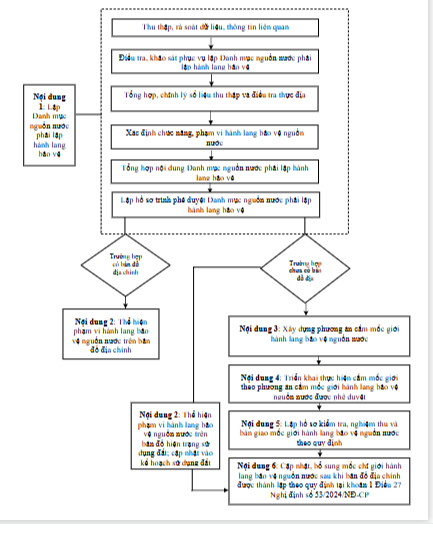
1. Establishing the List of water sources requiring the establishment of protection zones:
a) Collecting and reviewing relevant data and information;
b) Investigating and surveying to serve the establishment of the List of water sources requiring the establishment of protection zones;
c) Compiling and editing collected data and field investigation results;
d) Determining the function and scope of water source protection zones;
đ) Summarizing the contents of the List of water sources requiring the establishment of protection zones;
e) Preparing documents for approval of the List of water sources requiring the establishment of protection zones and documents for review and acceptance of the List of water sources requiring the establishment of protection zones.
2. Representing the scope of water source protection zones on cadastral maps.
3. Developing plans for setting boundary markers for water source protection zones.
4. Implementing the setting of boundary markers for water source protection zones according to approved plans.
5. Preparing documents for inspection, acceptance, and handover of boundary markers for water source protection zones as prescribed.
6. Updating and supplementing boundary markers for water source protection zones after cadastral maps are established.
Chapter II
TECHNICAL PROCEDURES FOR ESTABLISHING WATER SOURCE PROTECTION ZONES
Section 1
ESTABLISHING THE LIST OF WATER SOURCES REQUIRING THE ESTABLISHMENT OF PROTECTION ZONES
WATER SOURCES
Article 4. Collecting and reviewing relevant data and information
1. Studying objectives, tasks, scope, subjects, time frame, content volume, and methods applied in the establishment of water source protection zones according to the approved outline.
2. Collecting and compiling relevant materials related to the survey area:
a) Materials on economic and social conditions, provincial and centrally-administered city planning, current status, land use planning, programs, and plans for developing industries affecting water resources;
b) Characteristics of topography, geology, hydrology, environment, channel bed changes, river and stream banks, canal, ditch, and creek beds;
c) Current status of surface water resource surveys and utilization in the survey area;
d) Morphological characteristics of rivers, streams, canals, and creeks including name, length, starting and ending points, administrative boundaries;
đ) List of lakes, ponds, swamps, and reservoirs that cannot be filled in; dams, hydropower and irrigation reservoirs, and other reservoirs on rivers and streams;
e) Landslide situations of sections of rivers, streams, canals, and creeks and lakes, ponds, swamps, and reservoirs listed in the list of lakes, ponds, swamps, and reservoirs that cannot be filled in;
g) Drainage axes for urban areas, concentrated residential areas, industrial zones, and clusters;
h) Current discharge of pollutants and wastewater into water sources, surface water quality, and reports assessing pollution, degradation, and depletion of water sources;
i) Nature reserves, religious and cultural activities, biodiversity, tourism development, and ecosystems related to water sources;
k) Livelihoods of communities living along rivers; current land use, economic, cultural, and social activities in the vicinity of water sources;
l) Materials on permits for surface water extraction and environmental permits;
m) Collecting current land use maps and cadastral maps;
n) Materials on current inland waterway transportation activities and the scope of infrastructure protection zones, information about established coastal protection zones (if applicable) for coastal water sources (lakes, swamps, ponds, and reservoirs and related objects) requiring the establishment of protection zones;
o) Other relevant materials.
3. Reviewing, tallying, and evaluating the completeness and reliability of collected materials.
4. Tallying and compiling lists of collected information, data, and materials:
a) Compiling a list of reliable information and data for the survey and establishment of the List of water sources requiring the establishment of protection zones;
b) Identifying missing information, data, and materials that need to be investigated and surveyed;
c) Preparing a report on the collection, review, and delivery of information and data products.
Article 5. Investigation and survey to establish the List of water sources requiring establishment of protective zones
1. Preparation:
a) Accepting the field investigation assignment;
b) Determining the content, subject, and scope of the field investigation (studying the investigation assignment and related documents; studying various types of maps, examining the distribution of residential areas, identifying objects that need focused investigation, and preliminarily delineating the focused investigation area on the map);
c) Preparing plans, schemes, and routes for field investigations: detailing the implementation plan for the investigation route; marking the route on land use maps or cadastral maps (in areas with cadastral maps); arranging human resources, moving machinery and equipment during the field investigation;
d) Preparing manpower, materials, tools, and machinery, equipment, and investigation documents: preparing equipment for the investigation work; installing, inspecting, calibrating, testing, and validating the operation of machinery before field investigation; preparing necessary documents, forms, and investigation sheets; preparing labor protection equipment; packaging equipment, documents, tools, and materials for transportation to the site;
đ) Contacting local authorities and other preparatory works.
2. Conducting field investigations:
a) Investigating, collecting, and updating data at relevant agencies in the locality: characteristics of surface water, current status of surface water extraction and discharge into water sources, current drainage status; current water quality status and pollution, degradation, depletion conditions; list of ponds, lakes, swamps, and floodplains not to be filled in; dams, hydropower reservoirs, irrigation reservoirs, and other reservoirs on rivers and streams; economic and social development situation; programs, plans, master plans, and strategies for developing industries affecting water resources; current land use status, economic, cultural, and social activities in the water source vicinity; water resource management work, prominent issues related to surface water extraction and discharge into water sources; construction projects (including above-ground, underground, and infrastructure systems) in the water source vicinity; current land use maps and cadastral maps;
b) Following the comprehensive investigation route along both sides of the river and stream banks and perpendicular routes to rivers, streams, canals, ditches; surveying around hydropower and irrigation dams, ponds, and lakes listed as not to be filled in to observe, describe, sketch, photograph, and collect information about the characteristics and features of rivers, streams, canals, ditches, ponds, lakes, swamps, and floodplains;
Surveying, measuring, and plotting on the map to determine the shoreline boundary: determining the current status and location of the waterline, terrain for sections of rivers, streams, canals, ditches without embankments or revetments; top of the revetment for sections with embankments or revetments; highest water level for natural and artificial lakes (excluding hydropower and irrigation reservoirs) and mean high tide level for coastal swamps and floodplains;
Conducting detailed investigations of sections of rivers, streams, canals, ditches: determining the name of the water source, administrative location, coordinates of start and end points; length of the section of river, stream, canal, ditch; direction of flow; function of the water source; observing, describing, photographing, sketching, and collecting information about topography, geology, hydrology, environment, ecology; changes in channel bottom, river, stream, canal, ditch banks in the surveyed area; activities of water extraction, use, and wastewater discharge; living conditions of residents near the water source; infrastructure facilities near the water source, and other related information, and in some cases, additional information such as follows:
For sections of rivers, streams prone to or at risk of erosion: administrative location, coordinates of start and end points of the eroded section; scale of the eroded section (length, width); observing, describing, photographing, sketching, and collecting information about: causes of erosion; topographic, geological, and vegetation cover characteristics;
For sections of rivers, streams, canals, ditches suffering from degradation, pollution, depletion, requiring restoration: visual assessment of water quality (color, smell); phenomena related to environmental pollution (fish jumping, algae bloom, and other related phenomena), collecting and investigating wastewater discharge facilities, information about water levels and flow rates on the river; main causes of pollution, degradation, depletion of water sources, and other related information;
For sections of rivers, streams, canals serving as drainage channels for urban areas, concentrated residential areas, industrial zones: observing, describing, photographing, sketching, and collecting information about the names of residential areas, urban areas, industrial zones; wastewater discharge activities, types of discharge, current water quality status, and other related information;
For sections of rivers, streams, canals associated with the livelihood of communities living along the river: activities linked to the livelihood of people living along the river (aquaculture, inland navigation, crop cultivation), observing, describing, photographing, sketching, and collecting information about living conditions of residents near the water source; infrastructure facilities near the water source and other related information;
d) Conducting detailed investigations of water sources with functions of protecting religious, cultural, biodiversity, and tourism activities: determining the name of the water source, administrative location, coordinates of start and end points; function of the water source, religious, cultural, biodiversity, and tourism activities, and other related information;
d) Conduct investigations and collect detailed information on ponds, lakes, reservoirs, and marshes that are not to be filled in: name, administrative location, coordinates, surface area of the pond, lake, reservoir, or marsh; managing unit; function of the pond, lake, reservoir, or marsh; observe, take photos, sketch, describe characteristics of the pond, lake, and embankment conditions, surrounding slope failures, religious and cultural activities with high value for biodiversity conservation, cultural preservation, and natural ecosystem protection and development.
For ponds and lakes with the function of supplying water for daily use, additional information on extraction volume, extraction unit, licensing situation, and other related information should be collected.
e) Conduct detailed investigations on dams, hydropower reservoirs, irrigation reservoirs, and other water extraction and utilization facilities on rivers and streams: determine the facility's name, type, administrative location, coordinates of main facility components, name of the extracted water source; key parameters of the facility regarding water usage purpose, capacity, irrigated area, installed power, extraction volume, managing unit, information about extraction permits, and other related information; observe, take photos, sketch, describe the living conditions of residents near the facility.
g) Record investigation information in field investigation forms and notebooks.
The format of the field investigation form is detailed in Model No. 01 of Appendix 02 issued together with this Circular.
h) Adjust and maintain field investigation data and equipment daily: review and adjust daily field investigation documentation (field investigation forms, field investigation notebooks, and other related documents); review and check the content and volume of work completed outside the field; adjust investigation route plans and schemes; adjust and supplement the volume and content of field investigation work if necessary; inspect and calibrate investigation equipment after each day of work.
3. Summarize, adjust, complete field investigation results, and submit products.
a) Adjust and finalize collected data, information, and field investigation results.
b) Enter investigation results into computers.
c) Process, adjust, and summarize collected data, information, and investigation results.
d) Prepare an investigation result report, diagrams of investigation routes and locations marked on current land use maps or cadastral maps; statistical tables summarizing investigation and survey results and proposed locations for setting up markers.
đ) Complete investigation records and documents and hand over products.
Article 6. Summary and Adjustment of Collected Data and Field Investigation and Survey Results
1. Review and classify collected data and field investigation results for evaluation purposes, categorized as follows:
a) Dams, hydropower reservoirs, irrigation reservoirs, and other reservoirs on rivers and streams.
b) Ponds, lakes, reservoirs, and marshes listed in the non-filling pond, lake, reservoir, and marsh directory and other water sources with a surface area of two hectares or more and less than two hectares as stipulated in Clause 2, Article 21 of Decree No. 53/2024/NĐ-CP dated May 16, 2024 of the Government detailing implementation of certain provisions of the Water Resources Law.
c) River, stream, canal, and creek sections serving as water supply sources for water supply facilities.
d) River, stream sections subject to or at risk of slope failure.
đ) Rivers, streams, canals, and creeks spanning multiple districts or provinces serving as drainage channels for urban areas, concentrated residential zones, and industrial clusters.
e) River, stream, canal, and creek sections suffering from degradation, pollution, depletion, requiring restoration and recovery of water resources.
g) Rivers, streams, canals, and creeks closely linked to the livelihoods of communities living along them.
h) Water sources with functions of protecting and preserving religious and cultural activities, cultural values, biodiversity, and tourism development not covered under point b of this clause.
i) Aggregate areas already having cadastral maps and current land use maps.
2. Evaluate the reliability of collected data and documents, select, and compile a list of documents for evaluation purposes according to required content.
3. Input data into computers, check, and synchronize data:
a) Design the presentation format of data files.
b) Review and input data to serve the compilation of information and data on current water sources and evaluations according to required content.
c) Input field investigation results and collected data.
d) Check, adjust, process entered data and information, synchronize data.
4. Process, aggregate data and information, and build tables, charts.
5. Aggregate, classify, and compile a Water Source Directory according to reviewed and classified groups.
Article 7. Determining the function and scope of the water source protection corridor
1. Determining the function of the water source protection corridor.
Based on the results of investigations and data collection under Articles 4, 5, and 6 of this Circular, the function of the water source protection corridor shall be determined as follows:
a) For the function of protecting the stability of riverbanks and preventing encroachment on land adjacent to water sources: identify sections of rivers, streams, canals, and ditches that are subject to erosion or at risk of erosion; sections of inter-district and inter-provincial rivers, streams, canals, and ditches serving as drainage channels for urban areas, concentrated residential zones, industrial zones, and clusters; sections of rivers, streams, canals, and ditches closely linked to the livelihoods of communities living along rivers; sections of rivers, streams, canals, and ditches supplying water to public water supply facilities for domestic and production purposes; ponds, lakes, swamps, and reservoirs listed in the prohibited land reclamation directory but experiencing erosion and supplying water for domestic and production purposes, regulating landscapes, and preserving religious, cultural, and biodiversity activities, and promoting tourism; reservoirs for irrigation and hydropower experiencing erosion and supplying water for domestic and production purposes, regulating landscapes, and preserving religious, cultural, and biodiversity activities, and promoting tourism;
b) For the function of preventing activities that pose a risk of water pollution and degradation: identify concentrated residential areas adjacent to rivers; sections of rivers, streams, canals, and ditches supplying water to public water supply facilities for domestic and production purposes; inter-district and inter-provincial sections of rivers, streams, canals, and ditches serving as drainage channels for urban areas, concentrated residential zones, industrial zones, and clusters; ponds, lakes, swamps, and reservoirs for irrigation and hydropower supplying water for domestic and production purposes; preserving religious, cultural, and biodiversity activities, and promoting tourism;
c) For the function of protecting rivers, streams, canals, and ditches that support the development of aquatic ecosystems and natural flora and fauna along water sources: identify sections of rivers, streams, canals, and ditches related to the development of aquatic ecosystems and natural flora and fauna along water sources; identify ponds, lakes, swamps, and reservoirs for irrigation and hydropower related to the development of aquatic ecosystems and natural flora and fauna along water sources;
d) For the function of protecting and conserving religious, cultural, and biodiversity activities, and promoting tourism related to water sources: identify sections of rivers, streams, canals, and ditches with conservation activities for religious, cultural, and biodiversity values: sections of rivers organizing festivals related to beliefs; sections of rivers, streams, canals, and ditches with high biodiversity, closely linked to the habitats of species listed in the priority conservation directory; sections of rivers, streams, canals, and ditches with tourism-related activities; ponds, lakes, swamps, and reservoirs for irrigation and hydropower associated with the protection and conservation of religious, cultural, and biodiversity activities, and promoting tourism related to water sources.
2. Based on the actual situation of the locality and the requirements for water source protection, the function of the water source protection corridor may be determined for the entire corridor or specific sections thereof.
3. Determining the scope of the water source protection corridor for each water source.
Based on the results of investigations, data collection, and determination of the function of the water source protection corridor as stipulated in Articles 4, 5, 6, and Clauses 1 and 2 of Article 7 of this Circular, and the provisions of Articles 22, 23, 24, and 25 of Decree No. 53/2024/NĐ-CP, the specific scope and coordinates of the boundary points of the water source protection corridor for each water source shall be determined.
4. Specifying the distance between boundary markers of the water source protection corridor for rivers, streams, canals, ditches, hydropower reservoirs, and ponds and lakes.
The determination of distances for boundary markers to indicate the water source protection corridor boundaries on cadastral maps for areas already having cadastral maps or to include them in the plan for setting boundary markers for water source protection corridors for areas without cadastral maps.
Based on the topography, population living in the area where boundary markers are planned to be set, and management requirements, the distance between two consecutive markers must not be less than 200 meters. Additional markers must be added at turning points and intersections of the water source protection corridor boundary lines with physical features.
5. Preparing information, data, and diagrams for water sources requiring the establishment of a protection corridor:
a) Preparing information and data to serve the preparation of diagrams for water sources requiring the establishment of a protection corridor, including: name of the water source; function of the water source protection corridor; scope of the water source protection corridor; location of boundary points of the water source protection corridor; location of dams, reservoirs for irrigation and hydropower, ponds, lakes, swamps, and water extraction facilities for domestic water supply; drainage locations; erosion-prone areas; areas for the protection and conservation of religious, cultural, and biodiversity activities, and tourism; areas with existing cadastral maps.
b) Preparing diagrams for water sources requiring the establishment of a protection corridor.
Article 8. Compilation of Content for the List of Water Sources to Establish Protective Zones
1. The content of the List of Water Sources to Establish Protective Zones as stipulated in Clause 1, Article 26 of Decree No. 53/2024/ND-CP shall be detailed as follows:
a) Name and administrative boundaries of water sources required to establish protective zones: clearly specify the commune, ward, town (hereinafter referred to collectively as commune), district, county, provincial city, centrally governed city (hereinafter referred to collectively as district);
b) Function of the protective zone for water sources: specify the function and total length of the entire protective zone or each section of the protective zone according to the requirements for protecting water sources;
c) Scope of the protective zone for water sources; coordinates of the points defining the scope of the protective zone for water sources (according to the VN2000 coordinate system, central meridian, zone 3 projection);°);
d) List of water sources required to implement boundary marker establishment for protective zones as stipulated in Clause 2, Article 28 and Clause 1, Article 29 of Decree No. 53/2024/ND-CP and the plan for establishing boundary markers for protective zones: specify the name of the water source; administrative boundaries; function of the protective zone for water sources; name and location of water extraction facilities providing water for daily use with a capacity of 5,000 m3/day-night or more; coordinates of points subject to landslides; priority order, implementation schedule for establishing boundary markers for protective zones.
2. Prepare complete information and data to demonstrate the scope of the protective zone for water sources on land registry maps or current land use status maps in accordance with laws on land.
Article 9. Preparation of Documentation for Approval of the List of Water Sources to Establish Protective Zones and Documentation for Review and Acceptance of the Product of the List of Water Sources to Establish Protective Zones
1. Preparation of documentation for soliciting opinions and approval of the List of Protective Zones for Water Sources:
a) Documentation for soliciting opinions in compliance with point a, Clause 3, Article 26 of Decree No. 53/2024/ND-CP;
b) Documentation for approval of the List in compliance with point b, Clause 3, Article 26 of Decree No. 53/2024/ND-CP.
2. Preparation of documentation for review and acceptance of the product of the List of Water Sources to Establish Protective Zones.
The product documentation includes both paper and digital formats: List of Water Sources to Establish Protective Zones; comprehensive report summarizing the results of implementation and related specialized reports; schematic diagram of water sources required to establish protective zones; table of detailed results collected, investigated, and surveyed according to the groups of information specified in Clause 1, Article 6 of this Circular and other relevant documents; USB containing all reports, information, and data.
Article 10. Demonstration of the Scope of the Protective Zone for Water Sources on Land Registry Maps
The demonstration of the scope of the protective zone for water sources on land registry maps or current land use status maps as stipulated in Article 27 of Decree No. 53/2024/ND-CP shall be carried out after the approval of the List of Water Sources to Establish Protective Zones.
Section 2
DEVELOPMENT OF BOUNDARY MARKER ESTABLISHMENT PLANS FOR PROTECTIVE ZONES FOR WATER SOURCES
Article 11. Contents of Implementing the Development of Boundary Marker Establishment Plans for Protective Zones for Water Sources
1. Survey and investigation of the area and determination of the location for establishing boundary markers for protective zones for water sources.
2. Compilation, processing, and analysis of information and data to develop boundary marker establishment plans for protective zones for water sources.
3. Preparation of documentation for approval of boundary marker establishment plans for protective zones for water sources and product documentation for review and acceptance.
Article 12. Surveying, investigating, and determining the location for setting boundary markers of water source protection zones
1. Study tasks, determine the locations of the proposed boundary marker points on the current land use map.
2. Survey the area for setting boundary markers of water source protection zones for other water sources as prescribed in Clause 1, Article 29 of Decree No. 53/2024/NĐ-CP including information such as topography and geology of the area; observation, description, and collection of additional information about landslides, exploitation conditions of water extraction facilities for domestic use; current demographic and construction conditions, assets attached to the land within the water source protection zone; production, business, and service activities within the water source protection zone; surveying conditions for providing materials for setting boundary markers of water source protection zones; current conditions of related protection zones within the water source protection zone.
3. Survey the area for setting boundary markers of water source protection zones for water sources as prescribed in Clause 2, Article 28 of Decree No. 53/2024/NĐ-CP including information such as topography and geology of the area; current demographic and construction conditions, assets attached to the land within the water source protection zone; production, business, and service activities within the water source protection zone; surveying conditions for providing materials for setting boundary markers of water source protection zones; current conditions of related protection zones within the water source protection zone.
4. Conduct surveys, collect topographic data, and determine the locations for setting boundary markers.
Article 13. Compilation, processing, and analysis of information and data for developing plans for setting boundary markers of water source protection zones
Based on the investigation and survey data as stipulated in Article 12 and the list of water sources required to set boundary markers of water source protection zones as prescribed in Point d, Clause 1, Article 8 of this Circular which has been approved, carry out the compilation, processing, and analysis of the following information and data:
1. Information and data on the current socio-economic development status and relevant planning; water resource management, issues in surface water resource exploitation, and other related information and documents.
2. Information and data on topography and geology of the area; landslide conditions, exploitation conditions of water extraction facilities for domestic use; current demographic and construction conditions, assets attached to the land within the water source protection zone; production, business, and service activities within the water source protection zone; conditions for providing materials for setting boundary markers of water source protection zones; current conditions of related protection zones within the water source protection zone.
3. Compile and analyze information and data to serve the preparation of documentation for developing plans for setting boundary markers of water source protection zones: compensation and support recipients (if applicable); conditions serving the implementation of boundary marker setting (materials, equipment, manpower); technical solutions to be implemented on-site.
Article 14. Preparing documents for approval of the plan to set boundary markers for water source protection zones and product documentation for review and acceptance
1. The content of the plan to set boundary markers for water source protection zones as stipulated in Clause 3, Article 29 of Decree No. 53/2024/NĐ-CP, specifically as follows:
a) Specific scope of the water source protection zone on the ground plan: the ground plan showing the scope of the zone; administrative boundaries; positions of the proposed water source protection zone boundary markers (buried markers, wall-mounted markers); positions of traffic, dike, and other related markers; relevant information and objects;
b) Coordinates of the boundary markers (according to VN2000 coordinate system with central meridian 3° projection); administrative location (commune, district), distances between boundary markers;
c) Compensation, support, and resettlement plan as prescribed (if applicable);
d) Organization and mobilization plan for materials, equipment, manpower, and technical solutions for implementation on-site for the following contents: tasks and responsibilities of participating parties in setting boundary markers; provision of materials, equipment for setting boundary markers; manpower for management, supervision, internal work, technical monitoring, and inspection; technical solutions for implementation on-site to serve the setting of boundary markers;
đ) Detailed budget for implementation costs: basis for preparing the budget; main expenses: material and tool costs; labor costs; machinery and equipment costs; general costs; compensation, support, and resettlement costs (if applicable); other costs; value-added tax;
e) Schedule for setting boundary markers and handing over boundary markers;
đ) Agency responsible for setting boundary markers; agency receiving boundary markers for management and protection;
2. The content of the plan to set boundary markers for water source protection zones as stipulated in Clause 3, Article 28 of Decree No. 53/2024/NĐ-CP is specified as follows:
a) Basic parameters of the reservoir: reservoir capacity, highest water level corresponding to design flood; crest elevation of the dam, land clearance elevation at the reservoir bottom;
b) Current land management and usage around the reservoir: clearly stating information about current land management and usage according to laws on land;
c) Determining the specific scope of the water source protection zone of the reservoir on the ground plan as stipulated in Point a, Clause 1 of this Article;
d) Coordinates, administrative locations, and distances between boundary markers as stipulated in Point b, Clause 1 of this Article;
đ) Mobilization plan for manpower, materials, construction, and land clearance on-site as stipulated in Point d, Clause 1 of this Article;
e) Schedule for setting boundary markers and handing over boundary markers, implementation costs;
3. Preparing documents for approval of the plan to set boundary markers for water source protection zones, including: draft report; draft decision approving the plan to set boundary markers for water source protection zones; relevant legal documents and supporting materials.
4. Preparing documents for review and acceptance of construction products from the plan to set boundary markers for water source protection zones.
Product documentation in paper and digital form includes: plan to set boundary markers for water source protection zones; comprehensive report summarizing implementation results and related specialized reports; detailed survey data table containing information as prescribed in Article 12 of this Circular and other relevant documents; USB storing all reports, information, and data.
Section 3
IMPLEMENTATION OF SETTING BOUNDARY MARKERS FOR WATER SOURCE PROTECTION ZONES
Article 15. Procedure for setting boundary markers for water source protection zones
1. Preparation work for setting boundary markers.
2. Construction of boundary markers for water source protection zones.
3. Preparing records of products to serve inspection, acceptance, and handover of boundary markers.
Article 16. Preparation work for setting boundary markers
1. Prepare manpower, machinery, equipment, materials, and detailed site plans of the water source protection zone according to the approved plan for setting boundary markers for the water source protection zone.
2. Prepare markers:
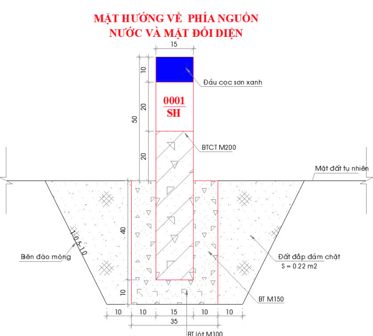
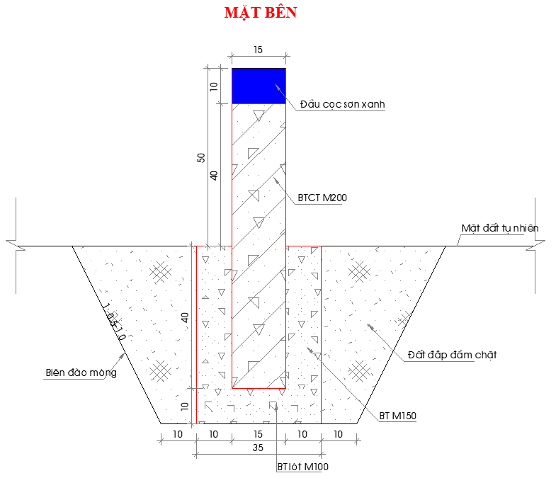
a) Buried markers used in setting boundary markers are prefabricated markers made of reinforced concrete, buried underground and fixed with concrete at the bottom and around the base of the marker. After burying the marker, the construction pit is filled and compacted with soil up to the natural ground level. The specific structure, size of buried markers, and the structure of marker plates are specified in Model No. 04 and Model No. 05 of Appendix 02 issued together with this Circular.
In cases where burial is not possible, surface-mounted markers on walls (mountain slopes, road bases, and other related objects) as stipulated in point b of this clause shall be used.
b) Surface-mounted markers on walls only use marker plates, which are embedded on the wall surface, as specified in Model No. 05 of Appendix 02 issued together with this Circular.
Article 17. Construction of boundary markers for water source protection zones
The construction of boundary markers for water source protection zones shall be carried out as follows:
1. Transfer the coordinates of the boundary markers from the map to the actual site.
2. Marking for construction: positions of markers outside the site are marked using temporary stakes that can be wooden or bamboo stakes ensuring stability during the process of burying the markers.
3. Establish a description of the water source protection zone:
a) General provisions for describing the water source protection zone: descriptions are established for all protection zone routes; data in the description must match the position marker diagram, each route may be described continuously along the entire route or divided into several sections.
The content of the description includes: current status on-site; positions and distances between markers; distinctive points determined on-site.
b) Description method: clearly describe the location of the protection zone route on-site sequentially according to the chosen direction; the description must be based on stable geographic features present on-site.
4. Construction of boundary markers: the construction of boundary markers outside the site is determined based on the position marker diagram and the positions of markers marked by temporary stakes. The implementation of burying markers must meet the following requirements:
a) Marker placement points are selected in areas with solid, stable foundations, convenient, and ensure long-term existence without being destroyed by geological structures and construction works.
b) Establish a diagram of the position of boundary markers for water source protection zones as specified in Model No. 02 of Appendix 02 issued together with this Circular, showing the position of boundary markers, topographic elements, and land features.
c) The position of boundary markers must facilitate surveying work and not affect accuracy.
d) Markers should not be buried in places prone to flooding, with high groundwater levels, or in areas scheduled for construction.
5. Measure the coordinates of boundary markers: the coordinates of boundary markers (X, Y) are determined based on the coordinates of the top center of the marker, with an allowable error not exceeding 0.3 meters in flat areas and 0.5 meters in mountainous areas and complex terrain with difficult access.
6. The construction of boundary markers for water source protection zones must also comply with regulations on establishing cadastral maps under land laws.
Article 18. Preparation of Product Documentation for Review, Acceptance, and Handover of Water Source Protection Zone Markers
1. Product documentation for inspection, acceptance of boundary marker installation works includes:
a) Description of water source protection zone corridors, location diagrams of boundary markers;
b) Machine testing documents, coordinate statistics table of corridor boundary markers for water source protection zones as specified in Model No. 03 of Appendix 02 issued with this Circular, USB data transfer device and other documents;
c) Technical summary report and inspection and acceptance documentation at various levels;
d) Handover record between the organization or agency responsible for installing boundary markers and the construction unit installing boundary markers.
2. Handover of boundary markers:
a) For hydropower reservoirs: the management and operation organizations of hydropower reservoirs shall install boundary markers and hand over the product documentation of boundary marker installation works to the People's Committee of the province for handing over the water source protection zone boundary markers to the People's Committee of the district or commune for management and protection;
b) For other water sources: the handover of boundary markers shall be carried out between the agency responsible for installing boundary markers and the agency receiving the handover of boundary markers as stipulated in the approved boundary marker installation plan for water source protection zones.
Article 19. Updating and Supplementing Water Source Protection Zone Boundary Markers After the Establishment of Land Use Maps
The updating and supplementing of water source protection zone boundary markers after the establishment of land use maps shall be conducted in accordance with Clause 1 of Article 27 of Decree No. 53/2024/NĐ-CP dated May 16, 2024.
Chapter III
IMPLEMENTING PROVISIONS
Article 20. Transitional Provisions
In cases falling under the transitional provisions regarding water source protection zones as specified in Points c, d, and đ of Clause 2 of Article 97 of Decree No. 53/2024/NĐ-CP, implementation shall be carried out in accordance with this Circular.
Article 21. Effective Date
This Circular takes effect from January 10, 2025.
Article 22. Responsibility for enforcement
1. Ministries, ministerial-level agencies, agencies under the Government, People's Committees of provinces and centrally-run cities, heads of units under the Ministry of Natural Resources and Environment, and related organizations and individuals are responsible for implementing this Circular.
2. The National Water Resources Management Agency is responsible for assisting the Minister of Natural Resources and Environment in supervising and inspecting the implementation of this Circular./.
|
Place of Receipt: - National Assembly Office and National Assembly Committees; - Government Office; - Supreme People's Procuracy; - Supreme People's Court; - Minister, Deputy Ministers of the Ministry of Natural Resources and Environment; - Departments of Natural Resources and Environment of provinces and centrally governed cities; - File: VT, KHCN, TNN. |
DEPUTY MINISTER DEPUTY MINISTER (Signed) |
Appendix 01
Diagram of the Process for Establishing Water Source Protection Zones
(Attached to Circular No. /2024/TT-BTNMT dated month day year 2024 of the Minister of Natural Resources and Environment)
Appendix 02
Forms, Records, and Boundary Marker Structures
(Attached to Circular No. /2024/TT-BTNMT dated month day year 2024 of the Minister of Natural Resources and Environment)
| Symbol | Le Minh Ngan |
| Form No. 01 | Field Survey Form |
| Form No. 02 | Location Diagram of Water Source Protection Zone Boundary Markers |
| Implementation Report of Production Projects of Supporting Industry Products Confirmed with Incentives | Coordinate Statistics Table of Water Source Protection Zone Boundary Markers |
| Form number 04 | Structure and Size of Buried Markers |
| Form number 05 | Marker Sign Structure |
Model No. 01. Field Survey Form
SOCIALIST REPUBLIC OF VIETNAMIndependence - Freedom - Happiness
FIELD SURVEY FORM
Project: …
Name of Water Source: …
Type of Water Source: River, Stream, Canal, Ditch, Creek Reservoir Lake, Pond, Lagoon
Coordinates of Survey Point: X = …; Y = …
(VN 2000 System, Central Meridian, Zone 3 Projection)0)
Administrative Location (Commune, District, Province) …
1. For Water Sources:
- Supply water for public and industrial use
- Drainage channel for urban areas, concentrated residential areas, industrial zones
- Water source with religious, cultural, biodiversity, and tourism functions
- Livelihood of communities living along rivers
- River or stream sections prone to or at risk of erosion
- River, stream, canal, or creek sections degraded, polluted, or depleted requiring restoration
- Other water sources
Related Information on Water Sources:
2. For Water Extraction and Utilization Works
.................................................................................................................................................................................................................................................................................................................................................................................................................................
Name of Water Extraction and Utilization Work: …
Type of Work: …
Main Work Coordinates: X = …; Y = …
Commune, District, Province: …
Commune, district, province:…
Purpose of KTSD:…
Scale of KTSD:…
Organizations and individuals managing KTSD:…
Information about Permit (if applicable):…
3. For ponds, lakes, swamps, and reservoirs that shall not be filled in:…
Coordinates of survey point: X = …; Y = …
Commune, district, province:…
Water surface area:…
Managing unit:…
Function of pond, lake, swamp, and reservoir:…
2. For Water Extraction and Utilization Works
……………………………………………………………………………….………….
4. For dams and reservoirs for hydropower and irrigation
Project Name:...
Main Work Coordinates: X = …; Y = …
Commune, District, Province: …
Commune, district, province:…
Reservoir capacity/dam length, dam height:…
Irrigation area:…
Installed power capacity:…
Managing unit:…
Information about Permit (if applicable):…
2. For Water Extraction and Utilization Works
…………………………………………………………………………………………..
5. Other information
………………………………………………………………………………………………………………………………………………………………………………………………………………………………………………………………………………………
6. Sketch of survey point location
…, day … month … year… Survey Officer
Form No. 02. Sketch of boundary marker location for water source protection zone
SOCIALIST REPUBLIC OF VIET NAM
Independence - Freedom - Happiness
SKETCH OF BOUNDARY MARKER LOCATION FOR WATER SOURCE PROTECTION ZONE
1. Marker number:…
2. Belongs to river (name of river, stream, canal, ditch, creek): …
3. Approximate value: Elevation: …Longitude: …Latitude:…(VN 2000 system, central meridian, zone 3 projection)0)
Scale:…
4. Land area for marker construction:…m2
5. Scope of water source protection zone:…
Proposed marker number (if applicable)SH: abbreviated name of riverSurvey point number0001SHB
Location of marker: …, distance from …
At: village … - commune … - district … - province …
No. Serial NumberStandard ObjectMeasured Distance from MarkerNoteAzimuthDistanceABC CONSTRUCTION UNIT
(Signature)PROJECT OWNER
(Signature, full name, stamp)COMMUNE PEOPLE'S COMMITTEE
(Signature, full name, stamp)ENVIRONMENT AND NATURAL RESOURCES DEPARTMENT …
(Signature, full name, stamp)
Form No. 03. Table of coordinates for boundary markers of water source protection zone
SOCIALIST REPUBLIC OF VIET NAM
Independence - Freedom - Happiness
TABLE OF COORDINATES
BOUNDARY MARKERS OF WATER SOURCE PROTECTION ZONE
(Name of river, stream, canal, ditch, creek, reservoir) …
No.Marker NameVN 2000 coordinate system, central meridian, zone 3 projection0 (unit: meters)NotesXYY1 2 3 …
CONSTRUCTION UNIT
(Signature, full name, stamp)PROJECT OWNER
(Signature, full name, stamp)
Form No. 04: Structure and size of buried marker
The specific structure and size of the marker are detailed as follows: the marker column is made of reinforced concrete with a cross-section of 15cm x 15cm; length 90cm, of which the part above ground level is 50cm; the part buried underground is 40cm; the top of the marker is attached with a marker plate (embedded, the top surface of the marker plate is flush with the top of the concrete column) according to Form No. 05 Appendix 02 issued together with this Circular; the marker number is displayed at a position 10cm below the top of the marker on both sides of the marker, the font size of the marker number is 3cm high; the color of the marker column, except for the top of the column, is painted blue, color code R,G,B=0,0,255, the rest of the marker is painted white; the size of the base reinforcement concrete pad: 35cm x 35cm.
|
|
|
|
|
Form No. 05: Structure of marker plate
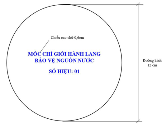 The marker plate is made of porcelain, white background, circular shape, diameter 12cm, thickness 3.8cm, and has good load-bearing capacity. The content of the plate is printed in capital letters, blue color, color code R,G,B=0,0,255, letter height 0.6cm, displayed as shown in Figure 2.
-
Marker Plate
原始文件(PDF)
关系图
点击文件即可打开。红色边框=改变效力的关系。