
Circular No. 32/2015/TT-BTNMT of the Ministry of Natural Resources and Environment stipulates the List of Place Names for Population, Topography, Hydrography, Economic and Social Purposes to Serve the Work of Establishing Maps of the Mainland Part of Binh Thuan Province. This Circular applies to relevant agencies, organizations, and individuals.
Scope of application
Ministries, ministerial-level agencies, government-affiliated agencies, People's Committees of provinces and centrally governed cities, and related organizations and individuals.
Key points
- Based on Decree No. 21/2013/NĐ-CP and Decree No. 45/2015/NĐ-CP, this Circular is issued to standardize the List of Place Names to serve the work of establishing maps.
- The List includes administrative units at the district level such as cities, towns, and districts within Binh Thuan Province.
- Information about the relative coordinates of place names is detailed on the map.
- This Circular takes effect from August 20, 2015.
🌐 Social impact of this document
- The positive impact is that standardizing and unifying the List of Place Names helps make the work of establishing maps more accurate and effective.
- The negative impact may be the burden of time and manpower for relevant agencies and organizations during the implementation process.
❓ Frequently asked questions
Which map does the standardized List of Place Names derive from?
The List is standardized from the National Topographic Map at a scale of 1:25,000 in the VN-2000 system.
Who does this Circular apply to?
This Circular applies to ministries, ministerial-level agencies, government-affiliated agencies, People's Committees of provinces and centrally governed cities, and related organizations and individuals.
When does this Circular take effect?
This Circular takes effect from August 20, 2015.
What types of place names does the List include?
The List includes place names for population, topography, hydrography, and economic and social purposes.
How are the district-level administrative units in Binh Thuan Province listed?
The Circular lists district-level administrative units including the city of Phan Thiet, town of La Gi, Bac Binh District, Duc Linh District, Ham Tan District, Ham Thuong Bac District, Ham Thuong Nam District, and Tuy Phong District.
Full text
CIRCULAR
Issued Domestic air passenger transport service on regular basic economy classlist of place names for residents, topography, hydrography, economic and social affairs
serving the establishment of land maps for the province B|| T||For power plants invested under the Build-Operate-Transfer (BOT) model, n is determined according to the operational period of the power plant stipulated in the BOT contract.
_________________________
Pursuant to Decree No. 21/2013/NĐ-CP dated March 4, 2013, promulgated by the Government, stipulating the functions, tasks, powers, and organizational structure of the Ministry of Natural Resources and Environment;
Pursuant to Decree No. 45/2015/NĐ-CP dated May 6, 2015 of the Government on surveying and mapping activities;
AT THE SUGGESTION OF THE DIRECTOR OF VIETNAM SURVEYING AND MAPPING AGENCY AND THE HEAD OF THE LEGAL AFFAIRS DEPARTMENT;
The Minister of Natural Resources and Environment issues the Circular on the List of Place Names for Residents, Topography, Hydrography, Economic and Social Affairs Serving the Establishment of Land Maps for the Province of Binh Thuan.
Article 1. This Circular includes the List of Place Names for Residents, Topography, Hydrography, Economic and Social Affairs Serving the Establishment of Land Maps for the Province of Binh Thuan.
Article 2. This Circular takes effect from August 20, 2015.
Article 3. Ministries, ministerial-level agencies, agencies under the Government, People's Committees of provinces and centrally-run cities, and relevant organizations and individuals are responsible for implementing this Circular./.
|
DEPUTY MINISTER
DEPUTY MINISTER
(Signed)
Nguyen Linh Ngoc
|
|
MINISTRY OF NATURAL RESOURCES AND ENVIRONMENT
ENVIRONMENT
|
SOCIALIST REPUBLIC OF VIETNAM
Independence – Freedom – Happiness
|
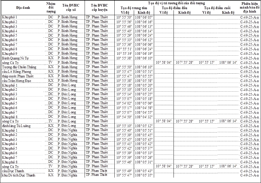
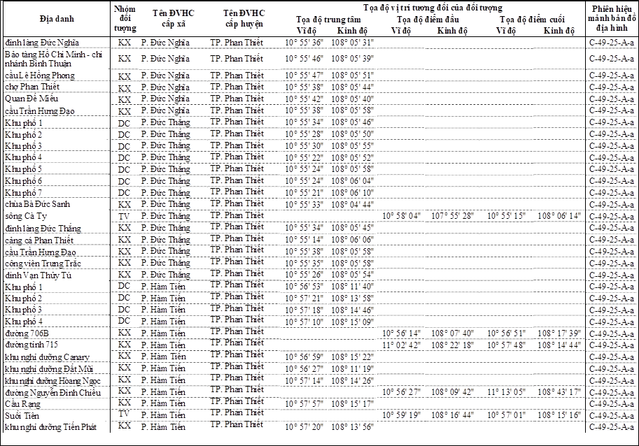
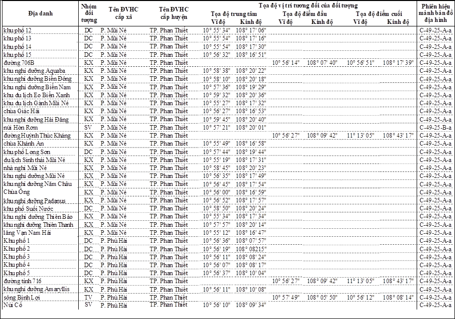
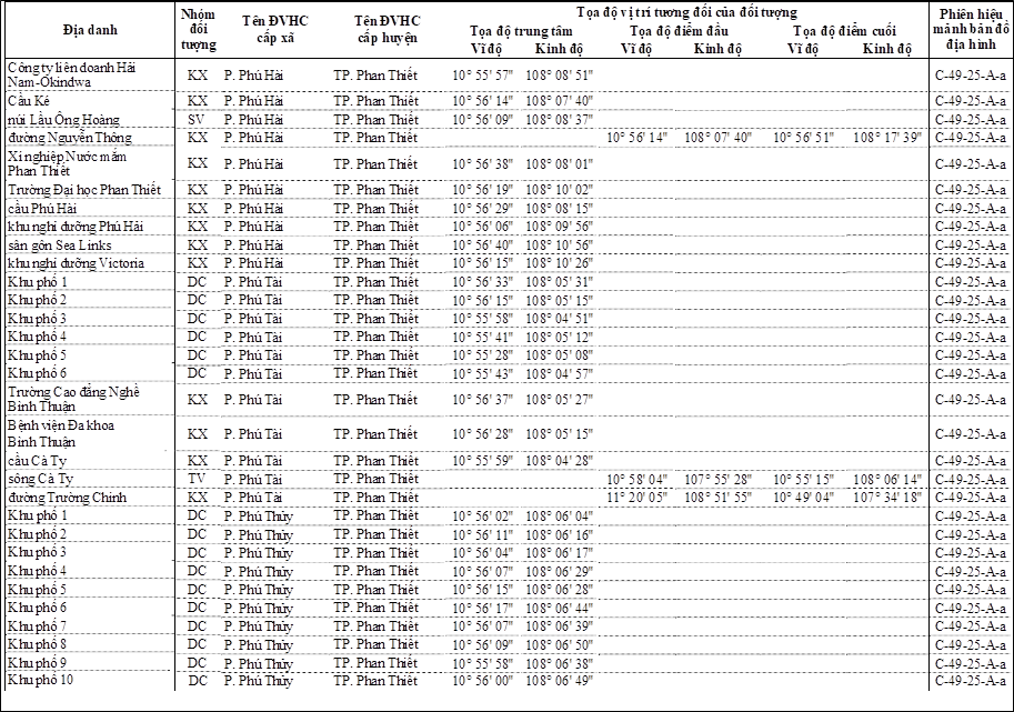
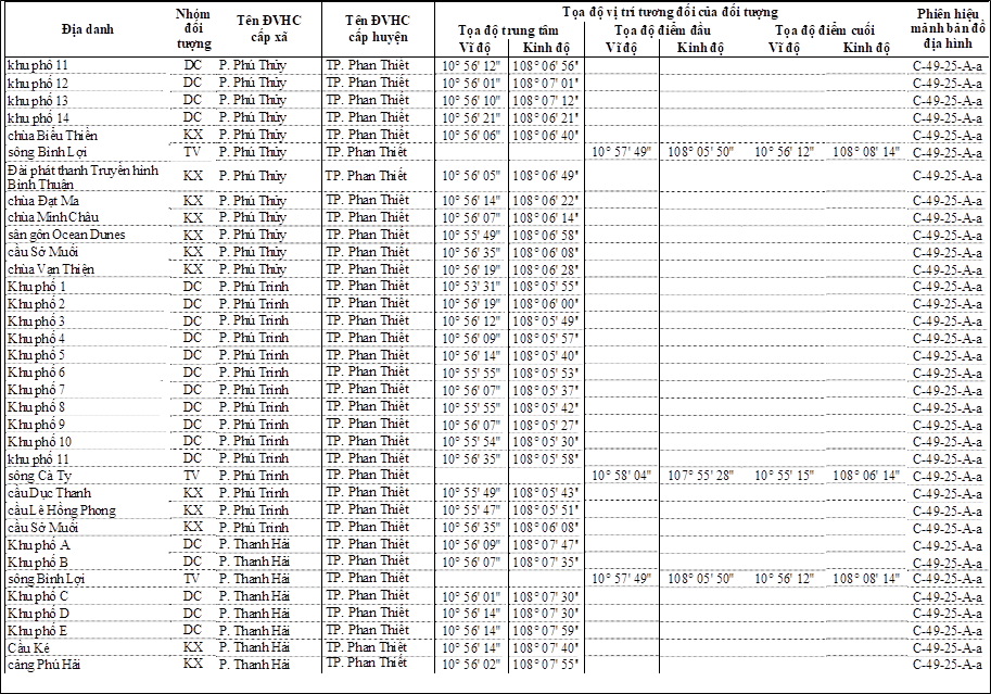
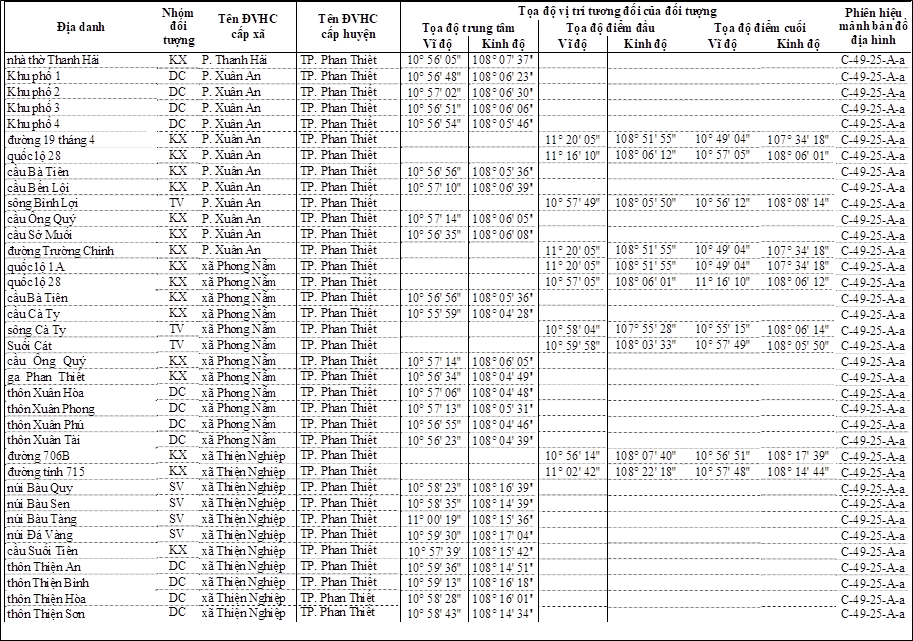
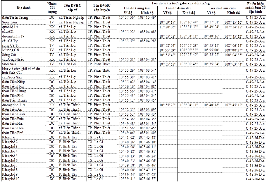
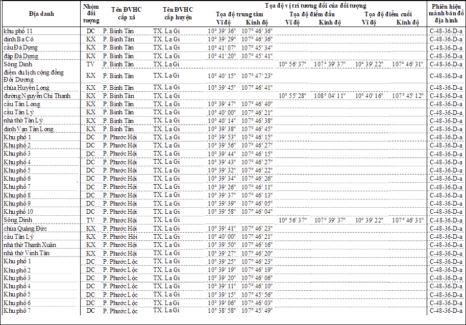
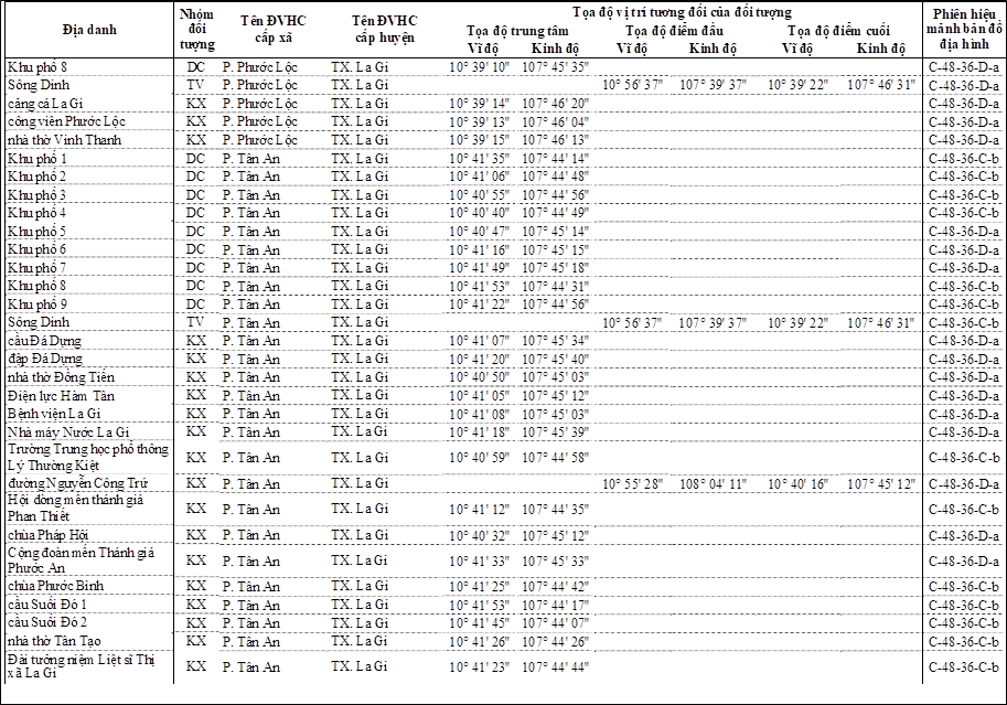
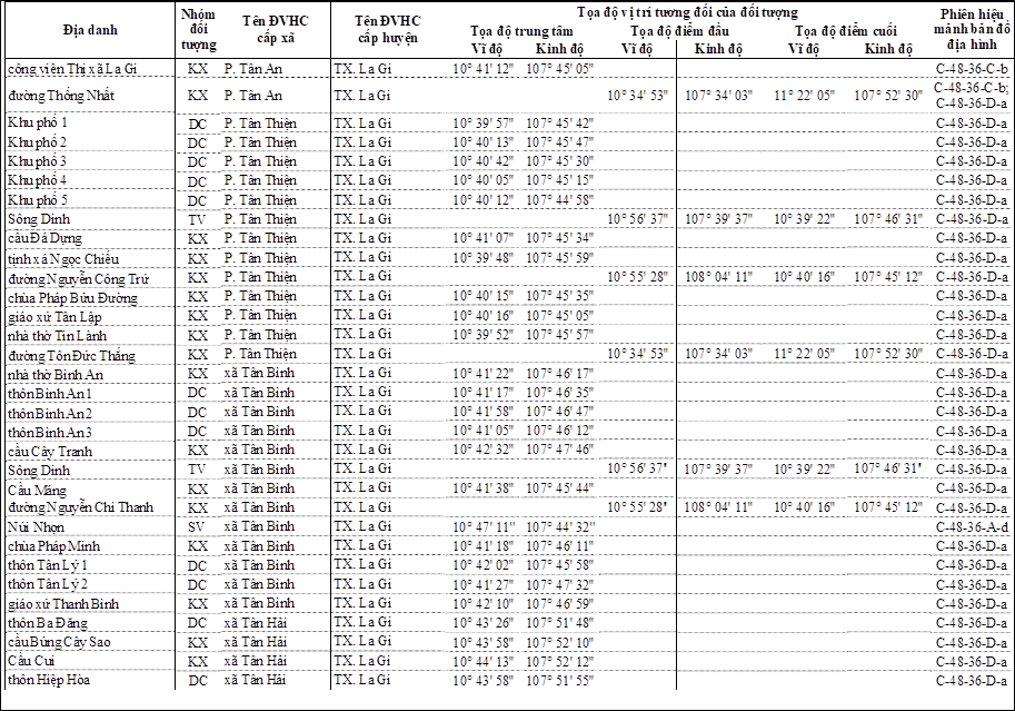
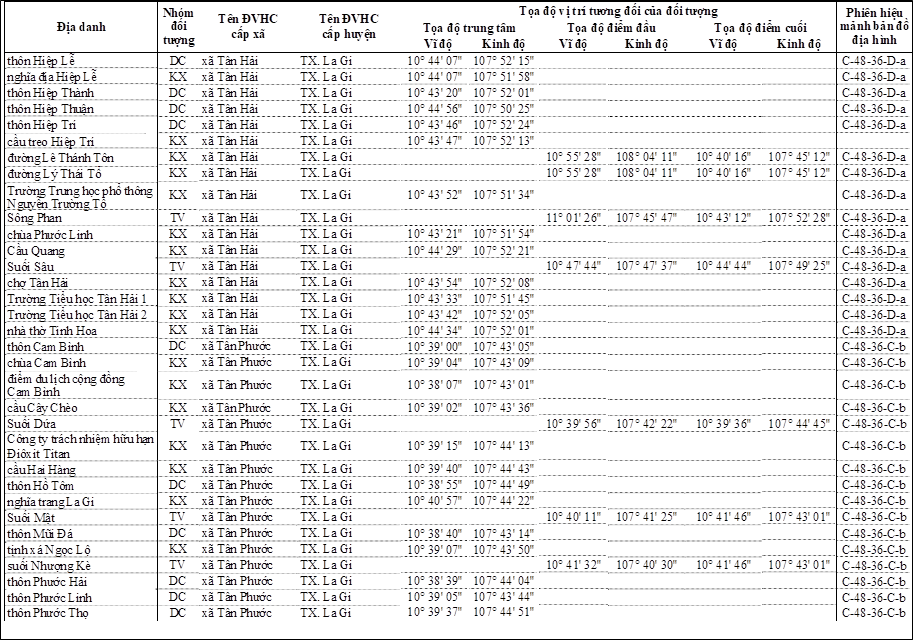
LIST OF PLACE NAMES FOR RESIDENTS, TOPOGRAPHY, HYDROGRAPHY, ECONOMIC AND SOCIAL AFFAIRS
SERVING THE ESTABLISHMENT OF LAND MAPS FOR THE PROVINCE OF BINH THUAN
(Issued together with Circular No. 32/2015/TT-BTNMT dated June 30, 2015 of the Minister of Natural Resources and Environment)
Part I
GENERAL PROVISIONS
1. The List of Place Names for Residents, Topography, Hydrography, Economic and Social Affairs Serving the Establishment of Land Maps for the Province of Binh Thuan is standardized based on place names listed on national topographic maps at a scale of 1:25,000 using the VN-2000 coordinate system.
2. The List of Place Names for Residents, Topography, Hydrography, Economic and Social Affairs Serving the Establishment of Land Maps for the Province of Binh Thuan is arranged alphabetically according to the names of administrative units at the district level, including cities, towns, and counties, wherein:
a) The "Place Name" column contains standardized place names;
b) The "Group of Objects" column contains symbols representing groups of place names, where: DC represents residential place names, SV represents topographical place names, TV represents hydrographic place names, and KX represents economic and social place names;
c) The "Name of Commune-level Administrative Unit" column contains the names of commune-level administrative units, where: P. is an abbreviation for "ward", TT. is an abbreviation for "town";
d) The "Name of District-level Administrative Unit" column contains the names of district-level administrative units, where: TP. is an abbreviation for "city", H. is an abbreviation for "county", TX. is an abbreviation for "town";
e) The "Relative Position Coordinates of the Object" column contains the relative position coordinates of the corresponding geographic object, if the geographic object is represented on the map by a point symbol or area symbol, then the coordinate value corresponds to the "Central Coordinate" column, if the geographic object is represented on the map by a line symbol, then the coordinate value corresponds to the "Starting Coordinate" and "Ending Coordinate" columns;
f) The "Topographic Map Sheet Code" column contains the code of the topographic map sheet at a scale of 1:25,000 used for listing place names.
Part II
LIST OF PLACE NAMES FOR RESIDENTS, TOPOGRAPHY, HYDROGRAPHY,
ECONOMIC AND SOCIAL AFFAIRS SERVING THE ESTABLISHMENT OF LAND MAPS
FOR THE PROVINCE OF BINH THUAN
The List of Place Names for Residents, Topography, Hydrography, Economic and Social Affairs Serving the Establishment of Land Maps for the Province of Binh Thuan includes place names of administrative units at the district level listed in the following table:
district
city
|
Serial number |
Implementation in the preceding year 1. The Minister, head of a ministry-level agency, head of an agency under the Government, Chairman of the People's Committee of a province or centrally governed city shall be responsible for implementing this Circular. ADJUSTMENT at all levels pursuant to the Conclusion ||| Phan |
Page |
|
1 |
town directly under the Central Government La Equipment |
|
|
|
|
|
|
2 |
Bac 59/2019/NĐ-CP Duc uilding v |
|
|
|
|
|
|
3 |
District Linh Portable gas fire extinguisher with a capacity of no less than 3kg or portable water-based fire extinguisher with a capacity of no less than 6 liters |
|
|
|
|
|
|
4 |
District Ham Tan |
|
|
|
|
|
|
5 |
District Thuan Tanch |
|
|
|
|
|
|
6 |
District Thuan Phong Linh |
|
|
|
|
|
|
7 |
District Thuan Phong Male |
|
|
|
|
|
|
8 |
District Tánh Tan |
|
|
|
|
|
|
9 |
District Railway transportation means Phong |




Original document (PDF)
Download
Relations map
Click a document to open. A red border = a relation that changes validity.
Translations
This document is available in the following languages: