
This Circular specifies the presentation and creation of administrative boundary maps (ABM) at commune, district, and provincial levels. The main contents include: using appropriate base maps for each geographic region; displaying ABM lines, ABM markers, and distinctive points as prescribed; editing map data accurately and clearly; presenting the outer frame of the ABM according to the prescribed model. Special attention should be paid to using a light pink border color for ABM lines, extending the boundary line by 2 cm at the start or end points surrounding administrative units.
适用范围
Authorities and organizations involved in creating ABM at commune, district, and provincial levels.
要点
- Using appropriate base maps for each geographic region
- Displaying ABM lines, ABM markers, and distinctive points as prescribed in Appendix 08
- Editing map data accurately and clearly
- Presenting the outer frame of the ABM according to the model prescribed in Appendix 09
- Using a light pink border color for ABM lines, extending the boundary line by 2 cm at the start or end points
🌐 本文件的社会影响
- Aiding in managing and distinguishing administrative boundaries between units
- Providing a legal basis for accurately and clearly creating ABM
- Supporting planning and socio-economic development at the local level
❓ 常见问题
Why must the boundary line be extended by 2 cm at the start or end points surrounding administrative units?
To ensure the completeness and clarity of the map, making it easier for viewers to identify administrative boundaries.
What automatic cleaning tools can be used with what margin of error when editing digital ABM?
For positions of ABM markers, distinctive points on ABM lines, and intersections of ABM lines, the margin of error is 0.001 meters; for other objects, it is 0.1 meters.
全文
|
MINISTRY OF NATURAL RESOURCES AND RURAL DEVELOPMENT _______ Number: 48/2014/TT-BTNMT |
SOCIALIST REPUBLIC OF VIET NAM Independence – Freedom – Happiness ________________________ Hanoi, August 22, 2014 |
CIRCULAR
Technical regulations on determining administrative boundary lines,
setting boundary markers and establishing administrative boundary records at all levels
________________
The Government issues this Decree on management and development of industrial clusters.
Pursuant to Decree No. 12/2002/NĐ-CP dated January 22, 2002 of the Government on surveying and mapping activities;
Pursuant to Decree No. 119/CP dated September 16, 1994 of the Government promulgating regulations on the management and use of administrative boundary records, administrative boundary maps, and administrative boundary markers at all levels;
Pursuant to Decree No. 21/2013/NĐ-CP dated March 4, 2013, promulgated by the Government, stipulating the functions, tasks, powers, and organizational structure of the Ministry of Natural Resources and Environment;
At the proposal of the Director of the Vietnam National Mapping Agency, the Head of the Science and Technology Department, and the Head of the Legal Affairs Department;
The Minister of Natural Resources and Environment issues this Circular on technical regulations for determining administrative boundary lines, setting administrative boundary markers, and establishing administrative boundary records at all levels.
PART I
GENERAL PROVISIONS
This Circular stipulates technical regulations for determining administrative boundary lines, setting administrative boundary markers on site, and establishing administrative boundary records at all levels.
This Circular applies to state management agencies and organizations and individuals related to the determination of administrative boundary lines, setting administrative boundary markers, and establishing administrative boundary records at all levels.
3. Characteristic point is a recognizable feature on the ground selected to serve the purpose of determining and describing the administrative boundary line.
4. Original administrative boundary map on-site is a map established from a printed map on paper showing the administrative boundary line, marker positions, and characteristic points on a base map with the consistency and confirmation of relevant localities serving as the basis for establishing the original administrative boundary map at the commune level.
5. Base map is a national topographic map used to determine the administrative boundary, set administrative boundary markers, and establish the original administrative boundary map on-site.
1. Preparation work.
2. Determining the ABL, marker positions, and characteristic points; establishing the original administrative boundary map on-site.
3. Preparing descriptions of ABLs at all levels.
4. Setting ABL markers.
5. Establishing ABL maps at all levels.
6. Creating and amending ABL records at all levels.
7. Inspecting, accepting, and delivering products.
Chapter II
TECHNICAL REGULATIONS
Preparation work includes collecting, studying, analyzing, and evaluating the following documents:
1. Official documents of competent state agencies regarding ABLs.
2. ABL records of related administrative units.
3. Topographic maps, cadastral maps, and other relevant documents and data.
1. Based on the documents from state agencies with authority regarding administrative boundaries, draw the administrative boundary lines onto the base map. Administrative boundary lines at all levels must be fully and accurately represented on the base map. In cases where administrative boundary lines at different levels overlap, only the higher-level administrative boundary line should be shown. If the administrative boundary lines overlap with national borders, they should be depicted according to the national border. After completing the drawing of the administrative boundary lines, preliminary positions for setting up boundary markers and distinctive points should be designed on the base map.
2. Determining administrative boundary lines, positions for setting up boundary markers, and distinctive points.
2. 1. Determining administrative boundary lines shall be carried out according to the following principles:
a) Surveying and determining administrative boundary lines in the field based on preliminary designs and the agreement of relevant localities;
b) Within a 2 cm range on both sides of the administrative boundary line on the map, new geographic elements that have appeared must be surveyed and added, and non-existent contents on the base map must be removed. Geographic elements selected as benchmarks for determining the positions of boundary markers and those with directional significance not yet on the base map must be fully surveyed and added. Linear objects must be drawn to the nearest turning point, including cases outside the 2 cm range along the administrative boundary. Supplementary surveys must comply with current regulations on establishing topographic maps at corresponding scales;
c) The accuracy of the administrative boundary lines must ensure the accuracy of the base map at the corresponding scale.
2. 2. Determining the positions for setting up boundary markers on the map and in the field shall be carried out according to the following principles:
a) Boundary markers must be set at the intersection of administrative boundary lines and at locations prone to future disputes. When it is impossible to place the marker directly on the administrative boundary line, it may be placed at a convenient, long-term stable location closest to the administrative boundary line. The position of the boundary marker must be agreed upon by relevant localities and marked in the field with wooden stakes. If the intersection of administrative boundary lines at different levels is a mountain peak or on a river, stream, lake, or sea, there is no need to determine the position of the boundary marker;
b) The number of positions for setting up boundary markers and the types of boundary markers to be set up shall be determined by the People's Committees at all levels related to the administrative boundary;
c) The marker numbers on each administrative boundary line shall be agreed upon by the relevant localities, numbered sequentially from 1 to the end or continuing from the existing marker numbers, based on the principle of no duplicate numbers, consisting of the following components in sequence:
- Abbreviations of the names of the localities within parentheses, with hyphens connecting the abbreviations of the directly managed administrative units.
- The number of direct administrative units managing the marker.
- The abbreviation of the administrative level of the marker immediately following the number of direct administrative units managing the marker: provincial level is T., district level is H., commune level is X.
Example: (PT-TĐ-LC) 3H.1 is the marker number for the administrative boundary between Phong Tho district, Tam Duong district, and Lai Chau city when the marker is placed directly on the administrative boundary line.
2. 3. Determining the positions of distinctive points on the administrative boundary line shall be carried out according to the following principles:
a) Distinctive points on the commune-level administrative boundary line are turning points and intersections of commune-level administrative boundary lines without markers. Distinctive points on the commune-level administrative boundary line are numbered continuously from 1 to the end, with the numbering direction agreed upon by adjacent administrative units;
b) Distinctive points on the district-level administrative boundary line are commune-level boundary markers located on the district-level administrative boundary line and intersections of commune-level administrative boundary lines with the district-level administrative boundary line without markers. The distinctive point numbers on the district-level administrative boundary line are abbreviations of the names of commune-level or district-level administrative units involved.
Example: (NT-NN-BG) the intersection of the administrative boundaries of three communes: Nam Tam, Sin Ho district, and Nung Nang commune, Bang Giang district, Tam Duong district;
c) Distinctive points on the provincial-level administrative boundary line are district-level boundary markers located on the provincial-level administrative boundary line and intersections of district-level administrative boundary lines with the provincial-level administrative boundary line without markers. The distinctive point numbers on the provincial-level administrative boundary line are abbreviations of the names of district-level or provincial-level administrative units involved.
Example: (SH-TC-MC) the intersection of the administrative boundaries of three districts: Sin Ho province Lai Chau and Tu Cha district, Muong Cha district, Dien Bien province.
2. 4. Preparing explanatory diagrams
a) Explanatory diagrams shall be prepared only for urban areas or densely populated areas when the administrative boundary map cannot show the position of the administrative boundary line. The scale of the explanatory diagram, the scope of preparing the explanatory diagram for the entire administrative boundary line of the administrative unit, and separate preparation for each boundary line or section shall be decided by adjacent administrative units based on necessity;
b) The materials used to prepare the explanatory diagram of the administrative boundary are the latest topographic maps with a larger scale than the commune-level administrative boundary map or the latest cadastral maps within the area. In cases where there is no such material, the explanatory diagram must be surveyed and drawn in the field. The explanatory diagram of the administrative boundary has the same size as the sheet of the base topographic map and is presented according to the model specified in Appendix 11 issued together with this Circular.
2. 5. All results of determining the administrative boundary lines, positions for setting up boundary markers, and distinctive points shall be reflected on the original administrative boundary map based on actual conditions.
3. Regulations on establishing the original administrative boundary map based on actual conditions
On the printed base map of the commune-level administrative boundary, new contents appearing, modifications, or deletions must be detailedly indicated using consistent symbols, specifically as follows:
3. 1. Within a 2 cm range on both sides of the administrative boundary line, survey and add new geographic elements that have appeared and represent them on the map using similar numerical symbol sets but distinguishable from existing contents on the map. In some cases, supplementary geographic elements in the form of lines or regions may be allowed to extend beyond the range to ensure continuous monitoring.
3. 2. The results of supplementary surveying must be immediately corrected after on-site measurement. The results must be carefully and clearly presented using a pen with fine, non-blurring ink, minimizing arbitrary corrections, erasures, and hand-drawn lines. The southern part of the original on-site cadastral map sheet must clearly record the following information: surveyor, date of survey, checker, date of correction.
3. 3. The contents of supplementary surveying and editing of the original on-site cadastral map include:
a) New geographical elements that have not appeared on the map or are incorrect must be supplemented or corrected according to the principle of place name conversion issued by the Ministry of Natural Resources and Environment. In cases where there is insufficient space on the map for writing, it is permissible to supplement on notebooks for internal processing;
b) Areas of encroachment must be fully supplemented, including areas outside the 2 cm zone on both sides of the cadastral boundary line;
c) Areas that cannot be surveyed due to prohibition shall be marked with a circled boundary and annotated as "prohibited area";
d) Rivers, streams, canals, and ditches related to determining the cadastral boundary line must be fully supplemented, even if they are shorter than 2 cm on the map scale and less than 1 meter wide. Islands, rocks, sandbanks, and submerged banks must also be fully supplemented and clearly noted under which administrative unit they belong;
đ) For urban residential areas or places with dense geographic features, the supplementary surveying and editing of geographic elements to determine the cadastral boundary line, in addition to complying with the base map regulations, must also follow the following provisions:
- If the cadastral boundary line follows streets or alleys, these streets or alleys must be drawn at the topographic map scale.
- At locations requiring information to describe the cadastral boundary line, geographic elements including houses on both sides of the street, fence boundaries, cultural facilities, orientation points, distinctive points, and other related geographic elements must be measured and drawn at scale. In other cases, it is permissible to draw combined blocks or generalize, represent half-scale or non-scale according to the topographic map regulations.
- In cases where the density of geographic elements is too high, not allowing representation on the original on-site map at the initially designed scale, it is permissible to reduce symbols or create additional extracts when necessary.
e) On the base map, objects and place names that no longer exist must be crossed out with a red diagonal line "X". When the object to be crossed out has a linear form, diagonal lines spaced 1 cm apart should be used to mark the crossing out, especially noting the start and end points of the section to be crossed out. If replacement is needed, a different color ink must be used to make it easily recognizable;
g) Determine the location of the People's Committee and indicate it with the word "UB" in red underscored.
3. 4. The results of supplementary surveying and control points (if any), in addition to being shown on the original on-site cadastral map, must also be transferred to a numerical drawing.
1. 1. Descriptions of the cadastral boundary line are established for all cadastral boundary lines and closed units according to administrative units. For administrative units with national borders, the cadastral boundary line must be described up to the national border. For administrative units with coastlines, the village-level cadastral boundary line must be described up to the waterline, and in cases where the village-level cadastral boundary line coincides with the district-level or provincial-level cadastral boundary line, the village-level cadastral boundary line must be described further to the baseline.
1. 2. When describing the village-level cadastral boundary line, a confirmation record of the village-level cadastral boundary line description must be established with the confirmation of relevant localities. The confirmation record of the district-level and provincial-level cadastral boundary line descriptions is based on compiling and summarizing the content from the confirmation records of the village-level cadastral boundary line descriptions.
1. 3. The data in the description must be consistent with the map or explanatory diagram (if available).
1. 4. Each cadastral boundary line may be described continuously along the entire line or divided into several sections. The content of the description includes:
a) The current state of the cadastral boundary line on site;
b) The position and distance between cadastral boundary markers and distinctive points already determined on site;
c) Do not describe geographic elements that do not appear on the map.
1. 5. In cases where there is no agreement among relevant localities regarding the cadastral boundary line, the description must clearly state the actual situation and proposals for resolution according to each party's viewpoint.
1. 6. Description method
a) Use clear language to accurately express the position of the cadastral boundary line on site sequentially according to the chosen direction;
b) The description of the cadastral boundary line segment must be based on stable geographic elements existing on site that the cadastral boundary line passes through or used as a basis for determination;
c) In special cases where the cadastral boundary line follows geographic elements that may change, such as rivers, streams, roads..., the confirmation record of the cadastral boundary line description must clearly state the consensus among adjacent administrative units on handling measures.
1. 7. Establishing a general description of the cadastral boundary line at all levels After establishing the description of the cadastral boundary line at all levels, a general description of the cadastral boundary line must be established. In the general description of the cadastral boundary line at each level, a summary of the current status of cadastral boundary line management, decisions of competent state agencies on the cadastral boundary line, natural area, and population of the administrative unit must be provided. The general description of the cadastral boundary line is established according to the model prescribed in Appendices 15a, 15b, 15c accompanying this Circular.
2. 1. The confirmation record of the village-level cadastral boundary line description must clearly show the following contents:
a) The map sheet number with the cadastral boundary line;
b) The explanatory diagram of the cadastral boundary line attached (if any);
c) Sections of the district-level and provincial-level cadastral boundary lines coinciding with the village-level cadastral boundary line;
d) Starting point and endpoint of the village-level cadastral boundary line;
đ) Number of cadastral boundary markers and distinctive points at various levels;
e) Number of cadastral boundary line segments, length, and measurement method, direction of each segment.
2. 2. The confirmation record of the village-level cadastral boundary line description is established according to the model prescribed in Appendix 12 accompanying this Circular.
3. Regulations for establishing confirmation records of descriptions of district-level and provincial-level cadastral boundary lines
3. 1. The confirmation record of the district-level and provincial-level cadastral boundary line description is established for each cadastral boundary line starting from the intersection point of the district-level and provincial-level cadastral boundary lines.
3. 2. The confirmation description of the county-level administrative boundary road (ĐGHC) is compiled and summarized from the confirmation description record of the commune-level administrative boundary road that overlaps with the county-level administrative boundary road. The confirmation description of the provincial-level administrative boundary road is compiled and summarized from the confirmation description of the county-level administrative boundary road that overlaps with the provincial-level administrative boundary road.
3. 3. The confirmation description of the county-level and provincial-level administrative boundary roads must clearly reflect the following contents:
a) The map sheet number with the cadastral boundary line;
b) Segments of the provincial-level administrative boundary road overlapping with the county-level administrative boundary road (for the description of the county-level administrative boundary road);
c) Starting point and endpoint of the county-level and provincial-level administrative boundary road;
d) Number of administrative boundary road markers and distinctive points on the county-level and provincial-level administrative boundary road;
đ) Number of segments, length, and direction of each segment of the administrative boundary road.
3. 4. The content and data in the confirmation description of the county-level and provincial-level administrative boundary roads must be consistent with the content and data in the administrative boundary road dossier of the related commune and county levels.
3. 5. The confirmation description of the county-level and provincial-level administrative boundary roads shall be established according to the model prescribed in Appendix 13 and Appendix 14 issued together with this Circular.
Administrative boundary markers are divided into three levels: commune, district, and province, and are used appropriately for corresponding administrative levels. Depending on specific topographical conditions, one of the following three types of markers may be designed and implemented:
1. 1. Buried marker: Used in all areas, made of reinforced concrete with a strength grade of M25 (TCVN 6025 1995) or higher. The marker has a core of steel bar F8, 15cm long above which there is a cross symbol as the center of the marker. The marker can be precast and buried or poured directly on-site. Specifications for the buried marker are stipulated in Appendix 01 issued together with this Circular.
1. 2. Attached marker: Used when the marker position is selected on a rock base. The marker has a surface size of 30cm x 30cm, with a minimum height of 20cm above the rock surface and is plastered flat on all sides. The marker is made of reinforced concrete with a strength grade of M25 or higher. The marker has a core of steel bar F8, 15cm long above which there is a cross symbol as the center of the marker.
1. 3. Buried marker flush with the sidewalk or road: Used when the marker position is selected as a sidewalk or road. The marker has a surface size of 40cm x 40cm, with a height of 40cm. The marker is made of reinforced concrete with a strength grade of M25 or higher. The marker has a core of steel bar 08, 15cm long above which there is a cross symbol as the center of the marker flush with the marker's surface.
1. 4. Notes on the marker surface
a) For buried markers, the notes are written in uppercase letters in three rows:
- Top row: "ADMINISTRATIVE BOUNDARY PROVINCE" (DISTRICT, COMMUNE) or abbreviated as "BORDER".
- Middle row: Name of the administrative unit. - Bottom row: The first number is the administrative unit code sharing the marker, followed by the letter 'T', 'H', or 'X' corresponding to the provincial, district, or commune level marker, followed by a period and the marker sequence number.
- All notes on the marker surface must be engraved deeply about 0.5 cm. Characters and numbers have a height of 3cm and width of 2cm; character stroke width is approximately 0.5cm. The top row of characters is about 5cm - 6cm from the top edge, with spacing between rows of characters about 2.5cm - 3.0cm.
b) Markers attached on rock surfaces and buried flush with sidewalks or roads:
- On the marker surface, 5cm from the top edge is the line of text "BOUNDARY MARKER" with a height of 6cm and width of 3cm. In the middle is a circle, with the top part indicating the marker number and the bottom part indicating the distance to the intersection of administrative boundary roads. Outside the circle is the scope of administrative units and arrows pointing to the intersection of administrative boundary roads. Character and number sizes are 4cm high and 2cm wide. All notes, characters, and numbers are engraved deeply, with character strokes approximately 0.5cm wide.
Details of the notes on the marker surface are specified in Appendix 02 issued together with this Circular.
2. Setting up administrative boundary markers
2.1. Administrative boundary markers at all levels must be set up at positions agreed upon and legally confirmed by adjacent administrative units. The side of the marker bearing the name of an administrative unit should face towards that unit.
2.2. When setting up administrative boundary markers, representatives of state administrative agencies of adjacent administrative units and representatives of higher-level state administrative agencies must witness the process. When setting up provincial-level administrative boundary markers, representatives of state administrative agencies of adjacent administrative units must also witness the process.
2.3. After setting up the administrative boundary markers, a confirmation diagram of the marker location must be established. When drawing the marker location diagram, at least three (03) stable long-term objects must be chosen as reference points to enable the recovery of the marker's position in case it is lost or destroyed later. Measurement data from the marker to the reference points for azimuth angles should be taken to whole seconds and distances to 0.1 meters; the confirmation diagram of the marker location is carried out according to the model prescribed in Appendices 03a, 03b, and 03c issued together with this Circular.
2.4. After completing the setup of administrative boundary markers, the markers at all levels must be handed over to the directly managing administrative units and a handover record must be established according to the model prescribed in Appendix 07 issued together with this Circular.
3. Measuring coordinates and elevations of commune-level administrative boundary markers
3.1. Coordinates and elevations of commune-level administrative boundary markers are measured directly on-site using common surveying equipment such as GPS receivers and electronic total stations. Control points for coordinate and elevation measurements are national control points within the survey area. If GPS technology is used, the observation time should be adjusted based on the distance from control points to the markers requiring coordinate determination but should not be less than 60 minutes.
3.2. The process of calculating adjustment errors to determine the coordinates and elevations of commune-level administrative boundary markers follows the process of calculating adjustment errors for control networks at various levels. Commune-level administrative boundary marker coordinates are calculated in the VN-2000 system, with a projection zone of 3 degrees suitable for the central meridian of the topographic map used as the base for creating the commune-level administrative boundary map in that area.
3.3. The root mean square error of coordinates and elevations of commune-level administrative boundary markers after adjustment must not exceed 0.3 meters for planimetric coordinates and 0.5 meters for elevations. In difficult-to-access areas, these errors may be increased to 0.5 meters for planimetric coordinates and 0.7 meters for elevations.
3.4. After calculating the mean square error, a Table confirming the coordinates of the commune-level administrative boundary marker (ABM), the coordinate values, and the height of the ABM shall be filled out to the nearest 0.01 meters according to the model prescribed in Appendix 04 issued together with this Circular.
4. Determining the coordinates of characteristic points on the commune-level administrative boundary line
The coordinates of characteristic points on the commune-level administrative boundary line are determined from digital topographic maps used as the base for the commune-level administrative boundary map. The coordinates of characteristic points are taken to the nearest 0.01 meters, and the Table of coordinates of characteristic points on the commune-level administrative boundary line shall be carried out according to the provisions set forth in Appendix 05 issued together with this Circular.
5. Determining the coordinates and heights of administrative boundary markers and characteristic points on the district-level and provincial-level administrative boundary lines
5.1. The Table of coordinates of administrative boundary markers and characteristic points on the district-level and provincial-level administrative boundary lines shall be established based on the Table confirming the coordinates of the commune-level administrative boundary markers. Among them:
a) Commune-level administrative boundary markers located on the district-level administrative boundary line and the intersection points between the commune-level administrative boundary line and the district-level administrative boundary line without markers shall be considered characteristic points on the district-level administrative boundary line;
b) District-level administrative boundary markers located on the provincial-level administrative boundary line and the intersection points between the district-level administrative boundary line and the provincial-level administrative boundary line without markers shall be considered characteristic points on the provincial-level administrative boundary line.
5.2. In cases where the base map for the commune-level administrative boundary map has a different mathematical basis than that of the district-level and provincial-level administrative boundary maps, the coordinate values must be converted to the correct mathematical basis of the district-level and provincial-level administrative boundary maps.
5.3. The Table of coordinates of administrative boundary markers and characteristic points on the district-level and provincial-level administrative boundary lines shall be established according to the provisions set forth in Appendix 06 issued together with this Circular. Coordinate values and heights shall be taken to the nearest 0.01 meters.
1. The base map used to establish administrative boundary maps at various levels is the latest digital national topographic map provided by the competent state agency.
2. The scale of the base map used to establish administrative boundary maps at various levels is specified as follows:
3. The sheet number of the administrative boundary map is the same as the sheet number of the corresponding base map. In addition to the numbering according to the regulations of the topographic map, each sheet of the administrative boundary map must be numbered sequentially from left to right and from top to bottom according to the arrangement of the sheets within each administrative unit. For example:
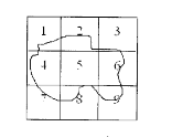
4. The commune-level administrative boundary map is established using digital technology based on the digital base map, the original field administrative boundary map, the Table confirming the coordinates of administrative boundary markers, and the Table of coordinates of characteristic points. The district-level and provincial-level administrative boundary maps are established on base maps with smaller scales, in which administrative boundary elements and related geographic elements are compiled from the commune-level administrative boundary map.
5. Content of Administrative Boundary Maps at Various Levels
5.1. Elements of the base map content.
5.2. Administrative boundary elements: Administrative boundary lines, administrative boundary markers, and characteristic points on administrative boundary lines; In cases where there are disputes along the administrative boundary line, the administrative boundary line on the map must reflect the actual management status according to the viewpoint of each adjacent administrative unit and indicate the symbol for the undetermined administrative boundary line.
5.3. Related geographic elements used as orientation aids to determine the position and describe the administrative boundary line.
5.4. Names of administrative units within the sheet; names of residential areas, hydrographic, and topographic features within the administrative unit and within 2 cm outside the administrative boundary lines at the time of map creation. All place names shown on the administrative boundary map within the administrative unit must be recorded in a census form of residential area names, topographic feature names, and hydrographic feature names according to the model prescribed in Appendix 10 issued together with this Circular.
5.5. Islands, rocks, shoals, and submerged reefs must note the name of the administrative unit managing them in parentheses under the name of the island or next to the island. In cases where islands, rocks, shoals, and submerged reefs are far from the mainland (outside the scope of the sheet containing mainland territory), a schematic diagram must be attached.
5.6. For administrative units with national borders, the administrative boundary line must be shown up to the national border.
6. Presentation of Administrative Boundary Maps
6.1. Administrative boundary maps at various levels are limited by the administrative boundary lines at each level, in which the map elements of the base map are presented according to the topographic map regulations, and administrative boundary elements are displayed according to the symbols prescribed in Appendix 08 issued together with this Circular.
6.2. At the beginning or end of administrative boundary lines surrounding administrative units or territories, the boundary segments are extended by 2 cm at the map scale.
6.3. Administrative boundary lines at various levels must be outlined with colored bands (bores) in light pink color, ensuring that they do not obscure administrative boundary elements and related geographic elements. For administrative boundary lines surrounding administrative units, the bore is only applied outwardly, while for internal administrative boundary lines, the bore is applied on both sides of the line.
6.4. On the district-level administrative boundary map, the commune-level administrative boundary lines must be outlined, while on the provincial-level administrative boundary map, only the district-level administrative boundary lines must be outlined.
6.5. The width of the bore for administrative boundary lines surrounding administrative units at various levels on the map is specified as follows:
a) Provincial level is 15 mm;
b) District level is 10 mm;
c) Commune level is 5 mm.
6.6. The width of the bore for district-level administrative boundary lines on the provincial-level administrative boundary map is 8 mm, evenly distributed on both sides at 4 mm each. The width of the bore for commune-level administrative boundary lines on the district-level administrative boundary map is 4 mm, evenly distributed on both sides at 2 mm each.
6.7. The presentation of the outer frame of the administrative boundary map is specified in Appendix 09 issued together with this Circular.
7. Regulations for Establishing Commune-Level Administrative Boundary Maps
7.1. Administrative boundary markers at various levels shall be depicted on the digital map according to the coordinate values in the Table confirming the coordinates of the commune-level administrative boundary markers.
7.2. Characteristic points shall be depicted on the digital map according to the coordinate values in the Table of coordinates of characteristic points on the administrative boundary line.
7.3. Based on the original field administrative boundary map, eliminate elements that no longer exist in the field, and simultaneously compile and supplement geographic elements according to the provisions set forth in point b, item 2.1, clause 2, Article 6 of this Circular.
7.4. The boundary lines at all levels shall be depicted on the commune-level cadastral map based on the original cadastral map of the actual terrain that has been uniformly determined by adjacent administrative units. On digital maps, the boundary lines must pass through characteristic points and cadastral boundary markers located along the boundary lines.
7.5. Commune-level boundary lines shall be drawn to the coastline. District-level and provincial-level boundary lines must be shown up to the baseline.
7.6. Compilation of digital commune-level cadastral maps:
a) The compilation of digital commune-level cadastral maps shall comply with current regulations on the compilation of digital topographic maps at the same scale, supplemented with cadastral elements into the group of border and boundary objects. Cadastral elements must be represented in digital form according to the provisions of Point 6.1, Clause 6, Article 9 of this Circular;
b) Cadastral elements shall be organized into separate layers and compiled according to commune-level administrative units. Other geographic elements shall remain unchanged according to the unit of the base map sheet;
c) In cases where there is a conflict regarding the position of cadastral boundary markers compared to nearby geographic elements, the compilation of these geographic elements on the map must be redone to ensure consistency;
d) In areas with high density of geographic features, when cadastral boundary markers or characteristic points coincide with geographic elements on the map, priority shall be given to representing boundary elements, geographic elements included in the description of cadastral boundaries, and nearby geographic elements with orientation characteristics;
đ) In cases where the cadastral boundary line coincides with linear objects on the map, based on the description, standardize the linear object and related objects according to their geometric relationship while maintaining the positions of cadastral boundary markers and characteristic points. After standardization, the cadastral boundary line shall be copied perfectly from that linear object;
e) Each cadastral boundary line must be a continuous line (Linestring) or consist of multiple connected segments with a tolerance of 0.001 meters. Where boundary lines at different levels overlap, they must be fully represented by perfect overlay;
g) When compiling digital cadastral maps, automatic cleaning tools may be used with a tolerance of 0.001 meters for positions of cadastral boundary markers and characteristic points on the cadastral boundary line and intersection points between cadastral boundary lines; 0.1 meters for other objects;
7.7. Compilation of commune-level cadastral maps for printing on paper
a) Cadastral maps printed on paper shall establish legal validity according to the provisions of Point 4.1, Clause 4, Article 10 of this Circular;
b) Compilation of commune-level cadastral maps for printing on paper shall be carried out using the same software version and symbol library used in the compilation of digital commune-level cadastral maps;
c) The accuracy and completeness of the data version serving printing on paper shall not be changed compared to the digital commune-level cadastral map data set;
d) During the compilation process, only the positions of annotations or some representative symbols may be adjusted to clearly present contents related to cadastral boundary lines on the printout;
đ) In cases of excessive density of objects, abbreviations of annotations according to traditional topographic map regulations may be allowed, and in exceptional cases, reduction to two-thirds of the specified size may be permitted to accommodate necessary contents;
e) In cases where the cadastral boundary line coincides with a linear object, the cadastral boundary line symbol shall be compiled as a diagonal hatch on both sides of the linear object to clearly indicate the extent of the overlapping section. The diagonal hatch shall follow the representation rules of traditional topographic maps;
8. Provisions for establishing district-level and provincial-level cadastral maps
8.1. District-level cadastral maps shall be established using digital technology from the source data of commune-level cadastral maps for printing on paper. Provincial-level cadastral maps shall be established using digital technology from district-level cadastral maps;
8.2. District-level and provincial-level cadastral boundary markers and characteristic points shall be depicted according to the coordinate values in the table of cadastral boundary markers and characteristic points along the district-level and provincial-level cadastral boundary lines. In cases of conflict regarding the position of markers compared to nearby geographic elements, the compilation of related geographic elements on the map must be redone to ensure consistency;
8.3. Cadastral elements and related geographic elements from the results of compiling commune-level cadastral maps shall be generalized and depicted on the base map according to the relevant content and display requirements at the corresponding scale. Related content objects on the base map must be edited and compiled appropriately without contradiction;
8.4. Cadastral boundary lines at all levels in district-level and provincial-level cadastral maps shall be based on inheriting the results of compiling commune-level cadastral maps. In cases of conflict, corrections and compilations must be made appropriately, prioritizing cadastral elements while ensuring completeness as described in the corresponding cadastral boundary descriptions;
8.5. Compilation of district-level and provincial-level cadastral maps for printing on paper shall be carried out according to the regulations applicable to the compilation of commune-level cadastral maps for printing on paper;
|
Administrative Level |
Urban areas, plains |
Mountainous regions, coastal areas |
|
Commune level |
1:2.000-1:10.000 |
1:5.000-1:10.000 |
|
District Level |
1:5.000-1:50.000 |
1:10.000-:50.000 |
|
Provincial level |
1:10.000-1:50.000 |
1:25.000-1:50.000 |
1. Contents of the Administrative Boundary File at the Commune Level
The Administrative Boundary File at the commune level includes the following documents:
a) Legal documents on the establishment of communes and adjustment of administrative boundaries of communes;
b) Administrative boundary map at the commune level;
d) Certificate of coordinates of boundary markers at the commune level;
đ) Table of coordinates of characteristic points on the administrative boundary line at the commune level;
e) General description of the administrative boundary situation at the commune level;
g) Minutes confirming the description of the administrative boundary line at the commune level;
h) Statistical forms for place names (population, hydrology, topography);
i) Minutes of handover of administrative boundary markers at various levels.
The Administrative Boundary File at the district level includes the following documents:
3. Contents of the Administrative Boundary File at the Provincial Level
The Administrative Boundary File at the provincial level includes the following documents:
a) Legal documents on the establishment of provinces and adjustment of administrative boundaries of provinces;
b) Administrative boundary map at the provincial level;
c) Certificates of schematic positions of boundary markers at the provincial level on the administrative boundary line of the province;
d) Table of coordinates of boundary markers and characteristic points on the administrative boundary line at the provincial level;
đ) General description of the administrative boundary situation at the provincial level;
e) Certificates of confirmation of the description of the administrative boundary line at the provincial level.
4. Establishing the Legal Validity of Documents in Administrative Boundary Files at Various Levels
4.1. Establishing the Legal Validity on Administrative Boundary Maps at Various Levels:
a) The Chairman of the People's Committee at the commune, district, and provincial levels signs to confirm outside the southeast corner of each piece of the administrative boundary map within their administrative management scope;
b) The Chairman of the People's Committee at the commune, district, and provincial levels related to the administrative boundary map signs to confirm inside the content of the administrative boundary map within their administrative management scope and at least 2cm to 3cm away from the common administrative boundary line with the level establishing the file.
4.2. Establishing the Legal Validity on Schematic Positions of Boundary Markers at Various Levels:
a) The Chairman of the People's Committee directly managing the boundary marker at the provincial level signs to confirm the schematic position of the provincial boundary marker, and a representative of the Ministry of Home Affairs signs to authenticate the schematic position of the provincial boundary marker;
b) The Chairman of the People's Committee directly managing the boundary marker at the district level signs to confirm and the Chairman of the People's Committee at the provincial level signs to authenticate the schematic position of the district-level boundary marker;
c) The Chairman of the People's Committee directly managing the boundary marker at the commune level signs to confirm and the Chairman of the People's Committee at the district level signs to authenticate the schematic position of the commune-level boundary marker.
4.3. Establishing the Legal Validity on Certificates of Coordinates of Boundary Markers:
a) The Chairman of the People's Committee directly managing the boundary marker signs to confirm on the certificate of coordinates of the corresponding level boundary markers;
b) A representative of the construction unit signs to confirm; the preparer and checker sign and clearly write their full names.
4.4. Establishing the Legal Validity on the General Description of Administrative Boundaries at Various Levels:
a) The Chairman of the People's Committee at various levels signs to confirm;
b) The preparer signs and clearly writes their full name.
4.5. Establishing the Legal Validity on Minutes Confirming the Description of the Administrative Boundary Line at the Commune Level:
a) The Chairman of the People's Committee of both sides involved at the commune level signs to confirm;
b) Representatives of specialized agencies at the district level including the Civil Service Department and the construction unit sign as witnesses.
4.6. Establishing the Legal Validity on Certificates Confirming the Description of the Administrative Boundary Line at the District and Provincial Levels signed by the Chairman of the People's Committee at the district and provincial levels directly involved.
4.7. Establishing the Legal Validity on Statistical Forms for Place Names (population, hydrology, topography) within the administrative territory of the commune signed by the Chairman of the People's Committee at the commune level, the preparer signs and clearly writes their full name.
4.8. Establishing the Legal Validity on Minutes of Handover of Boundary Markers at Various Levels:
a) The Chairman of the People's Committee at the provincial level signs to confirm the handing over party;
b) The Chairman of the People's Committee at the commune level signs to confirm the receiving party.
4.9. For copies of legal documents on the adjustment of administrative boundaries at various levels: the signing of certified true copies follows the provisions set out in Circular Joint Circular No. 55/TTLT-BNV-VPCP dated May 6, 2005 issued by the Ministry of Home Affairs and the Government Office guiding the format and technical presentation of administrative documents; Circular No. 01/2011/TT-BNV dated January 19, 2011 issued by the Ministry of Home Affairs guiding the format and technical presentation of administrative documents.
5. Presentation and Binding of New Administrative Boundary Files
5.1. New Administrative Boundary Files at various levels are presented and bound according to the provisions in Appendices 16a, 16b, 16c; the cover of the Administrative Boundary File is presented according to the provisions in Appendix 17 issued together with this Circular.
5.2. New Administrative Boundary Maps are presented and bound according to the provisions in Appendix 18 issued together with this Circular.
a) Legal documents on the establishment of districts and adjustment of administrative boundaries of districts;
b) Administrative boundary map at the district level;
c) Certificates of schematic positions of boundary markers at the district and provincial levels on the administrative boundary line of the district;
d) Table of coordinates of boundary markers and characteristic points on the administrative boundary line at the district level;
đ) General description of the administrative boundary situation at the district level;
e) Certificates of confirmation of the description of the administrative boundary line at the district level.
1. In cases where an administrative unit is adjusted according to the Decision of the competent state agency, rectification and supplementation of ABSD files shall be carried out in accordance with the following provisions:
1.1. Maintain the current status of the ABSD file being used after the Decision on adjusting the ABSD of the competent state agency is issued, without making any changes, erasures, or fragmentation of the existing file.
1.2. Documents and legal texts within the current file that remain consistent with the content of the new Decision on adjusting the ABSD of the competent state agency shall be photocopied and included in the rectified and supplemented ABSD file.
1.3. For ABSD lines that do not change and do not require additional ABSD markers, a copy of the new Decision on adjusting the ABSD of the competent state agency must be added to the current ABSD file.
1.4. New documents created in the ABSD file must establish their legal validity in accordance with Clause 4, Article 10 of this Circular.
1.5. All supplementary documents and those related to the rectification of the ABSD file must be added to the currently used file.
2. In cases where there is an adjustment to the ABSD line and new markers are buried, the following documents must be added to the current ABSD file:
2.1. A list of newly supplemented documents.
2.2. A copy of the legal document from the competent state agency regarding the adjustment of the ABSD.
2.3. A summary of changes to the ABSD.
2.4. An acknowledgment of the layout of the new marker positions.
2.5. A table confirming the coordinates of the ABSD markers and a table of coordinates of distinctive points on the new ABSD line.
2.6. A record confirming the description of the new ABSD line.
2.7. A handover record for the new ABSD markers.
Legal documents used for rectifying and supplementing the ABSD map include:
3.1. A copy of the decision of the competent authority regarding the adjustment of the ABSD.
3.2. The current ABSD map.
3.3. The base map provided by the competent state agency.
3.4. An acknowledgment of the layout of the new marker positions; a record confirming the description of the new ABSD line; an acknowledgment of the coordinates of the ABSD markers; a table of coordinates of distinctive points on the ABSD line.
4. Rectification and supplementation of the ABSD map shall be carried out in accordance with the following provisions:
4.1. Based on documents and legal texts concerning the adjustment of the ABSD, symbols for the administrative boundary lines, ABSD markers, administrative place names, residential place names, hydrographic, and topographic features shall be supplemented and modified accordingly, while also updating relevant geographic elements within a two-centimeter range on either side of the ABSD line at the commune level.
4.2. Present the ABSD map after rectification and supplementation in accordance with Appendix 9 attached to this Circular, with the upper left corner outside the map frame noting the content: "This map fragment has been rectified and supplemented pursuant to Decision number..., dated..., month..., year... of..." (fill in the name of the competent state agency responsible for the ABSD adjustment accurately based on legal documents).
5. Establishing legal validity on rectified and supplemented ABSD file documents at all levels shall be carried out in accordance with the following provisions:
5.1. Newly created documents shall establish their legal validity in accordance with Clause 4, Article 10 of this Circular.
5.2. Documents whose content remains unchanged shall be photocopied and acknowledged by the higher-level administrative state agency directly managing the administrative unit subject to adjustment.
6. Binding of rectified and supplemented ABSD file documents at all levels:
6.1. The newly rectified and supplemented ABSD map shall be bound into the current ABSD map file or in accordance with decisions of the competent state agency.
6.2. Newly rectified and supplemented documents shall be bound into the current ABSD file or in accordance with decisions of the competent state agency.
1. Requirements for Inspection and Acceptance:
1.1. The inspection and acceptance tasks of administrative boundary records must be carried out immediately after the completion of each project component or product.
1.2. Administrative boundary records upon acceptance must be established fully in accordance with the provisions of this Circular, data must be accurate, and language used in documents must be concise, clear, understandable, and consistent across levels.
1.3. Ensure technical consistency and accuracy during the implementation of tasks to supplement elements of administrative boundaries, geographic factors from the field onto topographic maps, and in the preparation of administrative boundary records and maps.
1.4. Clearly confirm the volume of completed tasks, compare with the Project, Technical Design - Estimate to serve as a basis for settlement.
1.5. Upon completion of the acceptance of administrative boundary records, a report must be prepared and submitted to the superior management agency detailing the quantity and quality of each document within the administrative boundary records. The report must include clear conclusions and evaluations of good quality or meeting requirements, deficiencies that need supplementation, correction, or redoing, completion time, and when submitting to superiors, it must be complete and accurate.
1.6. Inspection opinion sheets, acceptance minutes, and lists of accepted documents during inspection and acceptance shall be established according to the models specified in Appendices 19a, 19b, and 19c attached to this Circular.
1.7. Any opinions related to the handling requests of central agencies (Ministry of Home Affairs, Ministry of Natural Resources and Environment) must be documented separately in a request letter.
2. Responsibilities of Each Level in Inspection and Acceptance:
2.1. Construction units are responsible for inspecting all components of the product according to the technical criteria set forth in the content of this Circular.
2.2. People's Committees at various levels shall cooperate with construction units to inspect and accept administrative boundary records under their direct management and inspect and accept administrative boundary records of subordinate levels within their jurisdiction.
2.3. Departments of Home Affairs and Natural Resources and Environment have the responsibility to assist provincial People's Committees in guiding and organizing the inspection and acceptance work of administrative boundary records at all levels.
2.4. Provincial People's Committee shall accept and bear responsibility before the Government for the overall quality of administrative boundary records at all levels under its jurisdiction. To ensure long-term usability, if errors are discovered during use, the provincial People's Committee must promptly instruct relevant levels to correct, supplement, and report to the superior management agency without delay.
2.5. Administrative boundary records at all levels must be carefully reviewed regarding quantity and quality of all related documents before submission for inspection and acceptance to ensure the four characteristics of completeness, accuracy, consistency, and legality of the records.
3. Organization of Inspection and Acceptance
3.1. Each level's People's Committee shall establish a specialized team to assist in implementing the inspection and acceptance of administrative boundary records under their direct management and those of subordinate levels within their jurisdiction. The specialized team has the following responsibilities:
a) Monitor the organization and preparation of necessary works for inspection and acceptance of products immediately after completion;
b) Conduct legal and technical inspections on products subject to inspection and acceptance;
c) Identify deficiencies and require the construction unit to timely supplement, correct, or redo when necessary;
d) Confirm corrections, supplements, or redos (if any); assist the People's Committee at their own level in confirming the legality of the records, the completion of the construction unit, and draft the acceptance report to submit to superiors.
3.2. Organize inspection and acceptance of all components of administrative boundary map products and related documents as stipulated in the administrative boundary record dossier, including field measurement books, adjustment results, calculation tables, machine testing minutes, and other documents.
3.3. When inspecting and accepting administrative boundary records at each level, representatives of the superior People's Committee must directly participate; specifically, for the provincial administrative boundary record dossier, the provincial People's Committee shall organize the inspection and acceptance themselves.
3.4. Documents to be submitted before inspection and acceptance:
a) Administrative boundary maps;
b) Location diagrams of administrative boundary markers;
c) Confirmation tables of coordinates of administrative boundary markers;
d) Tables of coordinates of characteristic points on administrative boundary lines;
đ) Minutes confirming descriptions of administrative boundaries;
e) Statistical forms of place names.
4. Degree of Inspection and Acceptance
4.1. For village-level administrative boundary records:
a) Construction units shall organize self-inspection of 100% of all project components and documents in the administrative boundary records;
b) Village-level People's Committee shall monitor and supervise the construction process on-site and inspect 100% of all project components and documents of the village-level administrative boundary records during the construction unit's implementation;
c) District-level People's Committee shall be responsible for:
Inspecting and reviewing documents and the quality of village-level administrative boundary markers 30%;
Comparing coordinate measurement results of village-level administrative boundary markers and characteristic points on administrative boundary map data 30%.
Comparing documents with the field: inspect 30% of types of work and documents: administrative boundary maps, location diagrams of administrative boundary markers, minutes confirming descriptions of administrative boundaries, and statistical forms of place names.
d) Provincial-level People's Committee shall be responsible for:
Inspecting and reviewing documents and the quality of markers 20%;
Comparing coordinate measurement results of marker positions and characteristic points on administrative boundary maps 10%.
Comparing documents with the field: inspect 10% of types of work and documents: administrative boundary maps, location diagrams of administrative boundary markers, minutes confirming descriptions of administrative boundaries, and statistical forms of place names.
4.2. For district-level administrative boundary records:
a) Construction units shall organize self-inspection of 100% of all project components and documents in the administrative boundary records;
b) District-level People's Committee shall inspect 100% of all project components and documents of the district-level administrative boundary records implemented by the construction unit;
c) Provincial-level People's Committee shall inspect 50% of all project components and documents.
4.3. For provincial-level administrative boundary records:
a) Construction units shall organize self-inspection of 100% of all project components and documents in the provincial-level administrative boundary records implemented by the construction unit;
b) The People's Committee of the province shall inspect 100% of all items of work and documents in the administrative boundary survey dossier at the provincial level carried out by the implementing unit; the Ministry of Home Affairs shall take the lead in coordinating with the Ministry of Natural Resources and Environment to decide on the extent of inspection of items of work and documents within the administrative boundary survey dossier at the provincial level during the review process based on specific circumstances.
5. Packaging of administrative boundary survey dossier products at various levels
5.1. Prior to packaging the administrative boundary survey map products at various levels, a comprehensive review must be conducted according to the following contents:
a) Information on qualitative and quantitative elements of geographic features with the same name on the administrative boundary survey maps at various levels must not be contradictory, particularly those related to the description of administrative boundary lines at various levels;
b) Elements of administrative boundaries and geographic features displayed on topographic maps that are relevant must be reviewed and standardized 100% for accuracy and consistency between digital maps, original field maps, and confirmed descriptions of administrative boundary lines at various levels;
c) Administrative boundary survey maps printed on paper must have good quality, uniform tones, consistent forms and colors throughout the entire product. Content elements regarding administrative boundaries must be clear and easily recognizable.
5.2. Bordering procedures must be carried out before consolidating the content of village-level administrative boundary survey maps to district level and district-level maps to provincial level. All types of lines and areas intersecting with borders must be bordered according to the principle that these types of lines and areas should not be distorted, changed direction, or broken. Geographical objects and place names with the same name among adjacent administrative units must be consistent.
5.3. Packaging and submission of products can only be carried out after the final product acceptance inspection has been approved. Administrative boundary survey maps are packaged according to the regulations for establishing administrative boundary survey dossiers at various levels, including:
a) Digital map data and editing results for printing on paper;
b) Symbol libraries used to establish and edit administrative boundary survey maps at various levels;
c) Tables of coordinate points, characteristic points, and other intermediate products used during the establishment of maps.
5.4. GPS measurements according to the model in Appendix 7 of the National Technical Regulation on Establishing Coordinate Grids.
5.5. Results of coordinate and height benchmark adjustment calculations for administrative boundary lines at various levels.
5.6. Digital product items recorded on high-quality CDs, DVDs, or other digital storage devices.
6. The review of administrative boundary survey dossiers shall be implemented in accordance with the provisions of Clause 3, Section 2 of Circular Joint Circular No. 06/2006/TTLT-BTNMT-BNV-BNG-BQP dated June 13, 2006, issued by the Ministry of Natural Resources and Environment, the Ministry of Home Affairs, the Ministry of Foreign Affairs, and the Ministry of Defense guiding the management of measurement and mapping activities concerning administrative boundaries and national borders.
7. The management and use of administrative boundary survey dossiers at various levels shall be implemented in accordance with the provisions of Clause 2, Section 2 of Circular Joint Circular No. 06/2006/TTLT-BTNMT-BNV-BNG-BQP dated June 13, 2006, issued by the Ministry of Natural Resources and Environment, the Ministry of Home Affairs, the Ministry of Foreign Affairs, and the Ministry of Defense guiding the management of measurement and mapping activities concerning administrative boundaries and national borders.
Chapter III
ARTICLE TRANSITION PROVISIONS
Article 13. Effective Date
This circular takes effect from November 3, 2014, and revokes QCVN12:2008/BTNMT issued together with Decision No. 12/2008/BTNMT dated December 18, 2008, of the Minister of Natural Resources and Environment on the issuance of the "National Technical Regulation on Delimitation of Administrative Boundaries and Establishment of Administrative Boundary Survey Dossiers at Various Levels."
1. The Minister, Heads of Ministries equivalent to ministries, Heads of government agencies, Chairmen of provincial People's Committees under the central government, and related agencies, units, and individuals are responsible for implementing this Circular.
1. Ministries, ministerial-level agencies, government agencies; Provincial People's Committees, centrally governed cities shall be responsible for directing the implementation of this circular.
2. The Vietnam National Mapping Agency shall be responsible for inspecting the implementation of this circular.
3. Departments of Natural Resources and Environment shall assist Provincial People's Committees, centrally governed cities in implementing this circular at local levels. During the organization and implementation process, if there are difficulties or obstacles, agencies, organizations, and individuals shall promptly reflect them to the Ministry of Natural Resources and Environment for consideration, revision, and supplementation to ensure appropriateness.
During the organization and implementation process, if there are difficulties or obstacles, agencies, organizations, and individuals shall promptly reflect them to the Ministry of Natural Resources and Environment for consideration, revision, and supplementation to ensure appropriateness./.
|
DEPUTY MINISTER
DEPUTY MINISTER
(Signed)
Nguyen Linh Ngoc
|
原始文件(PDF)
关系图
点击文件即可打开。红色边框=改变效力的关系。
译本
本文件提供以下语言版本: